File:20110419 Ani North Walls Turkey Panorama.jpg
ナビゲーションに移動
検索に移動

このプレビューのサイズ: 797 × 91 ピクセル。 その他の解像度: 320 × 37 ピクセル | 640 × 73 ピクセル | 1,024 × 117 ピクセル | 1,280 × 146 ピクセル | 13,000 × 1,486 ピクセル。
元のファイル (13,000 × 1,486 ピクセル、ファイルサイズ: 16.72メガバイト、MIME タイプ: image/jpeg)
キャプション
キャプション
このファイルの内容を1行で記述してください
概要[編集]
| 解説 |
العربية: الحائط الشمالي لأني تركيا
Deutsch: Die Nordwand der historischen Stadt Ani im Grenzgebiet der Türkei und Armenien.
Ελληνικά: Βόρειο οχύρωμα του Ανί, Τουρκία.
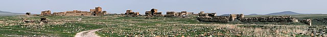
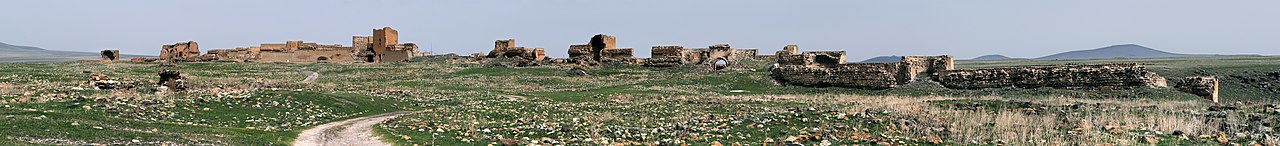
English: North wall of Ani, Turkey.
Français : Mur nord d'Ani, en Turquie. Ani fut la capitale de l'Arménie aux alentours de l'an mille.
Русский: Северная стена города Ани |
| 日付 | |
| 原典 | 投稿者自身による著作物 |
| 作者 | Ggia |
| 許可 (ファイルの再利用) |
Creative Commons License 3.0 Share-Alike |
| その他のバージョン | このファイルの派生的著作物: Ani North Walls Turkey banner.jpg |
| カメラの位置 | | 以下のサービスでこの位置を確認する: オープンストリートマップ |
|---|
評価[編集]
|
この画像は2012年1月30日の今日の一枚に選ばれました。その際の説明文は以下のとおりでした。 日本語: トルコ・アニ遺跡の北壁。 他の言語
Dansk: Nordmuren i ruinbyen Ani i det østlige Tyrkiet. English: North wall of Ani, Turkey. Español: Muralla norte de Ani (Turquía). Français : Mur nord d'Ani, en Turquie. Ani fut la capitale de l'Arménie aux alentours de l'an mille. Suomi: Pohjoismuuri nähtynä Anista, Turkista. Македонски: Северната ѕидина на стариот ерменски град Ани, денес во Турција. 日本語: トルコ・アニ遺跡の北壁。 中文: 土耳其阿尼北面城墙。 |
|
|
ライセンス[編集]
この作品の著作権者である私は、この作品を以下のライセンスで提供します。
このファイルはクリエイティブ・コモンズ 表示-継承 3.0 非移植ライセンスのもとに利用を許諾されています。
- あなたは以下の条件に従う場合に限り、自由に
- 共有 – 本作品を複製、頒布、展示、実演できます。
- 再構成 – 二次的著作物を作成できます。
- あなたの従うべき条件は以下の通りです。
- 表示 – あなたは適切なクレジットを表示し、ライセンスへのリンクを提供し、変更があったらその旨を示さなければなりません。これらは合理的であればどのような方法で行っても構いませんが、許諾者があなたやあなたの利用行為を支持していると示唆するような方法は除きます。
- 継承 – もしあなたがこの作品をリミックスしたり、改変したり、加工した場合には、あなたはあなたの貢献部分を元の作品とこれと同一または互換性があるライセンスの下に頒布しなければなりません。
| 注釈 | この画像には注釈がついています: コモンズで注釈を見る |

ファイルの履歴
過去の版のファイルを表示するには、その版の日時をクリックしてください。
| 日付と時刻 | サムネイル | 寸法 | 利用者 | コメント | |
|---|---|---|---|---|---|
| 現在の版 | 2013年1月21日 (月) 09:17 | 13,000 × 1,486 (16.72メガバイト) | Slick-o-bot (トーク | 投稿記録) | Bot: convert to a non-interlaced jpeg image (see bugzilla:17645) | |
| 2011年6月9日 (木) 16:08 | 13,000 × 1,486 (14.89メガバイト) | Ggia (トーク | 投稿記録) | white balance / more light in the image | ||
| 2011年6月9日 (木) 15:56 | 13,000 × 1,521 (15.33メガバイト) | Ggia (トーク | 投稿記録) | == {{int:filedesc}} == {{Information |Description ={{en|1=North wall of Ani, Turkey.}} {{el|1=Βόρειο οχύρωμα του Ανί, Τουρκία.}} |Source ={{own}} |Author =Ggia |Date |
このファイルは上書きできません。
ファイルの使用状況
以下の 71 ページがこのファイルを使用しています:
- Ani
- User:Ggia
- User:Ggia/Profile
- User:Samsara/POTY 2011 overview
- User talk:Ggia
- Commons:Conhece os nossos fotógrafos
- Commons:Conoce a nuestros fotógrafos
- Commons:Descobrètz nòstres fotografes
- Commons:Découvrez nos photographes
- Commons:Featured picture candidates/File:20110419 Ani North Walls Turkey Panorama.jpg
- Commons:Featured picture candidates/Log/June 2011
- Commons:Featured pictures/Places/Architecture/Castles and fortifications
- Commons:Featured pictures/Places/Panoramas
- Commons:Featured pictures/chronological/2011-A
- Commons:Fotoğrafçılarımızla tanışın
- Commons:Meet our photographers
- Commons:Meet our photographers/People
- Commons:Picture of the Year/2011/Galleries/2011-A
- Commons:Picture of the Year/2011/Galleries/A
- Commons:Picture of the Year/2011/Galleries/A/table
- Commons:Picture of the Year/2011/Galleries/ALL
- Commons:Picture of the Year/2011/Galleries/Index/6
- Commons:Picture of the Year/2011/Galleries/Index/ALL
- Commons:Picture of the Year/2011/Galleries/Index/Panoramic views
- Commons:Picture of the Year/2011/Galleries/JUN
- Commons:Picture of the Year/2011/Galleries/Panoramic views
- Commons:Picture of the Year/2011/Galleries/Panoramic views/Large
- Commons:Picture of the Year/2011/Galleries/Panoramic views/Small
- Commons:Picture of the Year/2011/Galleries/table
- Commons:Picture of the Year/2011/R1/20110419 Ani North Walls Turkey Panorama.jpg
- Commons:Picture of the Year/2011/Results/R1/ALL/table
- Commons:Picture of the Year/2011/Results/R1/Panoramic views
- Commons:Picture of the Year/2011/Results/R1/Panoramic views/table
- Commons:Poznaj naszych fotografów
- Commons:Quality images/Subject/Places/Man made structures/Panorama/archive 2008 to 2013
- Commons:Quality images candidates/Archives July 2011
- Commons:Scopri i nostri fotografi
- Commons:Scummigghia ê nostri fotògrafi
- Commons:Senarai Gambar Pilihan
- Commons:Temui jurugambar kami
- Commons:Unsere Fotografen stellen sich vor
- Commons:Unseri Fotografe stelle sich vor
- Commons:Upoznajte naše fotografe
- Commons:Биздин фотографтар менен таанышыңыз
- Commons:Запознајте ги нашите фотографи
- Commons:Знакомьтесь с нашими фотографами
- Commons:قابل مصورينا
- Commons:私達の写真家をご紹介します
- Commons:结识我们的摄影师
- Commons:结识我们的摄影师/人们
- Commons:우리들의 사진가를 만나보세요
- Commons talk:Picture of the Year/2011/Results/R1/ALL/table
- File:Ani (Turkey) banner North walls.jpg
- Template:Potd/2012-01
- Template:Potd/2012-01-30
- Template:Potd/2012-01-30 (da)
- Template:Potd/2012-01-30 (en)
- Template:Potd/2012-01-30 (es)
- Template:Potd/2012-01-30 (fi)
- Template:Potd/2012-01-30 (fr)
- Template:Potd/2012-01-30 (hu)
- Template:Potd/2012-01-30 (it)
- Template:Potd/2012-01-30 (ja)
- Template:Potd/2012-01-30 (ka)
- Template:Potd/2012-01-30 (ko)
- Template:Potd/2012-01-30 (mk)
- Template:Potd/2012-01-30 (nl)
- Template:Potd/2012-01-30 (ru)
- Template:Potd/2012-01-30 (uk)
- Template:Potd/2012-01-30 (zh-hans)
- Template:Potd/2012-01 (zh-hans)
_banner_North_walls.jpg)
グローバルなファイル使用状況
以下に挙げる他のウィキがこの画像を使っています:
- ar.wikipedia.org での使用状況
- be-tarask.wikipedia.org での使用状況
- be.wikipedia.org での使用状況
- bn.wikipedia.org での使用状況
- de.wikipedia.org での使用状況
- el.wikipedia.org での使用状況
- en.wikipedia.org での使用状況
- Geography of Turkey
- Portal:Geography
- Portal:Geography/Featured picture
- Wikipedia:Featured pictures/Places/Panorama
- Eastern Anatolia Region
- Ani
- Wikipedia:WikiProject Turkey/StatusArticleList
- User talk:Ggia
- Wikipedia:Featured pictures thumbs/28
- Wikipedia:Featured picture candidates/July-2011
- Wikipedia:Featured picture candidates/Ani
- Wikipedia:Wikipedia Signpost/2011-08-01/Featured content
- User talk:Jujutacular/Archive 13
- User talk:Jujutacular/Archive 14
- Wikipedia:Picture of the day/December 2012
- Template:POTD/2012-12-30
- Wikipedia:Main Page history/2012 December 30
- Portal:Geography/Featured picture/27
- Wikipedia:Wikipedia Signpost/Single/2011-08-01
- Talk:Ani/Archive 1
- Wikipedia:WikiProject Turkey/Recognized content
- eo.wikipedia.org での使用状況
- es.wikipedia.org での使用状況
- fa.wikipedia.org での使用状況
- fi.wikipedia.org での使用状況
- gn.wikipedia.org での使用状況
- he.wikipedia.org での使用状況
- hr.wikipedia.org での使用状況
- hu.wikipedia.org での使用状況
- hy.wikipedia.org での使用状況
- it.wikipedia.org での使用状況
このファイルのグローバル使用状況を表示する。