File:2022 Russian invasion of Ukraine.svg

Oprindelig fil (SVG fil, basisstørrelse 2.199 × 1.478 pixels, filstørrelse: 3,72 MB)
Captions
Captions
Rules for editing the map
|
| All edit warring, adding of unsourced information or performing a color change without consensus may result in the user being blocked. All contributions should first be discussed on the talk page. |
Beskrivelse

|
This file may be updated to reflect new information. If you wish to use a specific version of the file without new updates being mirrored, please upload the required version as a separate file. |
| Beskrivelse |
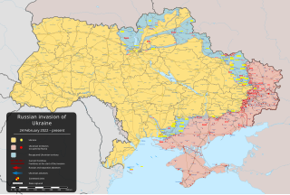
English: Ruslands invasion af Ukraine 2022 – væbnet konflikt, der begyndte den 24. februar 2022, da de russiske væbnede styrker gik ind i Ukraine [] |
||
| Dato | 24. februar 2022 (first version) | ||
| Kilde |
Own work based on: Russo-Ukrainian conflict (2014-2022).svg fra Rr016 & Ukraine adm location map improved.svg fra Yakiv Gluck
|
||
| Forfatter | Viewsridge | ||
| Andre versioner |
[]
|
||
| SVG udvikling | Vektorgrafikken blev lavet med Inkscape.
. This map is translated using SVG switch elements: all translations are stored in the same file.
|


.gif)

.gif)


_en.png)
_vi.png)
_ru.png)
.svg)
This file is translated using SVG For most Wikipedia projects, you can embed the file normally (without a To translate the text into your language, you can use the SVG Translate tool. Alternatively, you can download the file to your computer, add your translations using whatever software you're familiar with, and re-upload it with the same name. You will find help in Graphics Lab if you're not sure how to do this. |
Licensering
- Du må frit:
- at dele – at kopiere, distribuere og overføre værket
- at remixe – at tilpasse værket
- Under følgende vilkår:
- kreditering – Du skal give passende kreditering, angive et link til licensen, og oplyse om der er foretaget ændringer. Du må gøre det på enhver fornuftig måde, men ikke på en måde der antyder at licensgiveren godkender dig eller din anvendelse.
- deling på samme vilkår – Hvis du bearbejder, ændrer eller bygger videre på dette værk, skal du distribuere dine bidrag under den samme eller en kompatibel licens som originalen.
Filhistorik
Klik på en dato/tid for at se filen som den så ud på det tidspunkt.
| Dato/tid | Miniaturebillede | Dimensioner | Bruger | Kommentar | |
|---|---|---|---|---|---|
| nuværende | 14. maj 2024, 04:40 | | 2.199 × 1.478 (3,72 MB) | Physeters (diskussion | bidrag) | fix Derhachi |
| 13. maj 2024, 05:36 |  | 2.199 × 1.478 (3,72 MB) | Alexiscoutinho (diskussion | bidrag) | Updated Vovchansk per detailed map | |
| 13. maj 2024, 02:49 |  | 2.199 × 1.478 (3,72 MB) | Physeters (diskussion | bidrag) | Updates per the ISW; for future reference, sources (like SuriyakMaps) must first have their reliability vetted on the talk page before they can be used to update the map; at the moment, the only two verified sources are the ISW and the Detailed Map on Wikipedia | |
| 12. maj 2024, 10:34 |  | 2.199 × 1.478 (3,31 MB) | BlackShadowG (diskussion | bidrag) | File uploaded using svgtranslate tool (https://svgtranslate.toolforge.org/). Added translation for zh-tw. | |
| 12. maj 2024, 08:46 |  | 2.199 × 1.478 (3,31 MB) | Miki1234568 (diskussion | bidrag) | File uploaded using svgtranslate tool (https://svgtranslate.toolforge.org/). Added translation for pl. | |
| 12. maj 2024, 07:54 |  | 2.199 × 1.478 (3,31 MB) | BlackShadowG (diskussion | bidrag) | File uploaded using svgtranslate tool (https://svgtranslate.toolforge.org/). Added translation for zh-cn. | |
| 11. maj 2024, 23:02 |  | 2.199 × 1.478 (3,71 MB) | Mattia332 (diskussion | bidrag) | As per Renowned Unbiased Open Source "SuriyakMaps", Russian progress in Kharkov | |
| 10. maj 2024, 19:38 |  | 2.199 × 1.478 (3,71 MB) | Physeters (diskussion | bidrag) | add date marker | |
| 10. maj 2024, 19:31 |  | 2.199 × 1.478 (3,71 MB) | Physeters (diskussion | bidrag) | Update per the ISW; Russia re-enters northern Kharkiv Oblast | |
| 9. maj 2024, 04:45 |  | 2.199 × 1.478 (3,7 MB) | Physeters (diskussion | bidrag) | Updates per the ISW; add Ocheretyne |
Du kan ikke overskrive denne fil.
Filanvendelse
Flere end 100 sider henviser til denne fil. Den følgende liste viser kun de 100 første henvisninger. En komplet liste er tilgængelig.
- User:Hermes79
- User:Hermes7979
- User:RobiH
- User talk:Homoatrox
- File:2013 Hama Offensive.svg
- File:2015 Latakia Frontlines.svg
- File:20220408194618!2022 Russian invasion of Ukraine.svg (filomdirigering)
- File:2022 Russian invasion of Ukraine.jpg (filomdirigering)
- File:2022 Russian invasion of Ukraine.png (filomdirigering)
- File:2022 Russian invasion of Ukraine.png.webp (filomdirigering)
- File:2022 Russian invasion of Ukraine colorblind friendly.svg (filomdirigering)
- File:Aleppo Offensives 2015.svg
- File:Armed conflict zones in Myanmar.png
- File:Attaques-terroristes-meurtrières-au-21eme-siecle.png
- File:Battle of Daraa City.svg
- File:Battle of Hasakah.svg
- File:Battle of Qamishli.svg
- File:Battle of Raqqa.svg
- File:Battle of Tadmur.svg
- File:Battle of Western Qalamoun.svg
- File:Battlefields in The Global War on Terror.svg
- File:Battlefields in The Global War on Terror - edit03.png
- File:Battlefields in The Global War on Terror - edit04.png
- File:Benghazi Conflict Detailed Map.png
- File:Benghazi Conflict Detailed Map.svg
- File:Boko Haram insurgency map.svg
- File:Countries by soldier count.svg
- File:Deir ez-Zor clashes (2017).svg
- File:East Congo conflict map.svg
- File:GSPC map.png
- File:ISIS (Grey) Territory Change 2014-2016.gif
- File:Iraqi Civil War map (2014–present).png
- File:Islamist insurgency in Nigeria.svg
- File:Lebanese insurgency.png
- File:Lebanese insurgency.svg
- File:Libyan Civil War.svg
- File:Libyan war final-fr.svg
- File:Map of Ongoing conflicts around the world.png
- File:Map of terror of the Islamic State (ad-Daula al-islāmiyya).png
- File:Mexico states map small war.PNG
- File:Mosul offensive (2015) map.png
- File:Number of Terrorist Incidents.png
- File:Ongoing Conflicts (1).png
- File:Ongoing conflicts around the world.svg
- File:Pakistan-Waziristan-Map.png
- File:Political map Afar triangle.png
- File:Rif Damashq.svg
- File:Russian invasion of Ukraine 2022.svg (filomdirigering)
- File:Siege of Homs Map.svg
- File:Sinai insurgency.svg
- File:Somali Civil War (2009-present).svg
- File:Southern Sudan Civil War.svg
- File:Sudanese Internal Conflict.svg
- File:Syria and Iraq 2014-onward War map.png
- File:Syrian, Iraqi, and Lebanese insurgencies.png
- File:Syrian civil war.png
- File:Tadmur offensive (2015).jpg
- File:Territorial changes after 2016 Armenian-Azerbaijani clashes.jpg
- File:Turkish-PKK rebellion.svg
- File:War in North-West Pakistan.svg
- File:World2s.png
- File:Yemeni Civil War.svg
- File:Zones de conflit en Birmanie.png
- File:Саудовско-йеменский конфликт.png
- Template:Ongoing civil wars (maps)
- Category:2015 military intervention in Yemen
- Category:2016 Armenian–Azerbaijani clashes
- Category:Attack
- Category:Battle of Aleppo
- Category:Battles of Syria
- Category:Battles of the Syrian Civil War
- Category:Battles of the war in Donbas
- Category:Casualties of the War in Donbas
- Category:Civil wars
- Category:Conflicts
- Category:Conflicts by continent
- Category:Conflicts by country
- Category:Conflicts by type
- Category:Current civil wars maps
- Category:Feuds
- Category:Fights
- Category:Liberation of Palmyra (2016)
- Category:Maps of Somali Civil War
- Category:Maps of conflicts
- Category:Maps of disputed territories
- Category:Maps of terrorism
- Category:Maps of the 2014 pro-Russian unrest in Ukraine
- Category:Maps of the Demilitarized Zone of Korea
- Category:Maps of the Syrian Civil War in 2016
- Category:Maps of the War in Afghanistan (2001–2021)
- Category:Maps of wars
- Category:Military conflicts
- Category:Military maps of the world
- Category:Ongoing armed conflicts
- Category:Quarrels
- Category:Rebellions
- Category:Riots
- Category:Schisms
- Category:Syrian Civil War
- Category:Terrorism
.svg)
_Territory_Change_2014-2016.gif)
.png)
.png)
_map.png)
.png)
.svg)
.jpg)
Se flere henvisninger til denne fil.
Global filanvendelse
Følgende andre wikier anvender denne fil:
- Anvendelser på af.wikipedia.org
- Anvendelser på als.wikipedia.org
- Anvendelser på am.wikipedia.org
- Anvendelser på ang.wikipedia.org
- Anvendelser på an.wikipedia.org
- Anvendelser på ar.wikipedia.org
- Anvendelser på ary.wikipedia.org
- Anvendelser på arz.wikipedia.org
- Anvendelser på ast.wikipedia.org
- Anvendelser på azb.wikipedia.org
- Anvendelser på az.wikipedia.org
- Anvendelser på bat-smg.wikipedia.org
- Anvendelser på bcl.wikipedia.org
- Anvendelser på be-tarask.wikipedia.org
- Anvendelser på be.wikipedia.org
- Anvendelser på bg.wikipedia.org
- Anvendelser på bh.wikipedia.org
- Anvendelser på bn.wikipedia.org
- Anvendelser på br.wikipedia.org
- Anvendelser på bs.wikipedia.org
- Anvendelser på bxr.wikipedia.org
Vis flere globale anvendelser af denne fil.
Metadata
- Files that need updating
- SVG maps of the 2022 Russian invasion of Ukraine
- Catalan-language SVG maps
- Dutch-language SVG maps
- English-language SVG maps of Europe
- French-language SVG maps of Europe
- Georgian-language SVG maps
- German-language SVG maps
- Greek-language SVG maps
- Italian-language SVG maps
- Korean-language SVG maps
- Lithuanian-language SVG maps
- Malay-language SVG maps
- Mongolian-language SVG maps
- Multilingual SVG diagrams
- Polish-language SVG maps
- Portuguese-language SVG maps
- Russian-language SVG maps
- Spanish-language SVG maps
- SVG maps in traditional Chinese
- Turkish-language SVG maps
- Ukrainian-language SVG maps
- Vietnamese-language SVG maps