File:360° Flexenpass Straße.jpg
Zur Navigation springen
Zur Suche springen

Größe dieser Vorschau: 799 × 163 Pixel. Weitere Auflösungen: 320 × 65 Pixel | 640 × 131 Pixel | 1.024 × 209 Pixel | 1.280 × 261 Pixel | 8.858 × 1.809 Pixel.
Originaldatei (8.858 × 1.809 Pixel, Dateigröße: 11,19 MB, MIME-Typ: image/jpeg)
Bildtexte
Kurzbeschreibungen
Ergänze eine einzeilige Erklärung, was diese Datei darstellt.
Beschreibung[Bearbeiten]
| Beschreibung |
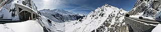
Deutsch: 360° Panorama von der Flexenpaßstaße mit Blick auf den Ort Stuben am Arlberg in Vorarlberg. Am 3. August 1895 wird unter Baumeister Johann Bertolini mit dem Bau der Flexenstraße von Stuben über den Flexenpass nach Lech bis Warth begonnen.
English: 360 ° panorama of the Flexen Pass Road overlooking the city of Stuben and the Arlberg range in Vorarlberg. the construction of the road begun on 3 August 1895 with the construction of the portion linking Stuben with Lech and Warth. The road was designed by the famous architect John Bertolini.
Français : Panorama à 360° sur la route du Flexen Pass, montrant la ville de Stuben et le massif d'Arlberg, dans le Vorarlberg. Cette route a été construite à partir de 1895 pour le tronçon de Stuben aux hameaux de Lech et Warth, sous la direction de l'architecte John Bertolini.
|
||
| Datum | |||
| Quelle | Eigenes Werk | ||
| Urheber | böhringer friedrich | ||
| Genehmigung (Weiternutzung dieser Datei) |
Ich, der Urheber dieses Werkes, veröffentliche es unter der folgenden Lizenz: Diese Datei ist unter der Creative-Commons-Lizenz „Namensnennung – Weitergabe unter gleichen Bedingungen 2.5 generisch“ (US-amerikanisch) lizenziert.
|
||
| Andere Versionen |

|

| 360° | Dieses Bild in einem interaktiven Panoramabetrachter ansehen.
|
|---|
This Photo was taken by Böhringer Friedrich.
|
Feel free to use my photos, but please mention me as the author and if you want send me a message. or (rufre@lenz-nenning.at) |
| Kameraposition | | Dieses und weitere Bilder auf OpenStreetMap |
|---|
| Bildnotizen | Diese Datei ist annotiert: Betrachte diese auf Commons. |

Dateiversionen
Klicke auf einen Zeitpunkt, um diese Version zu laden.
| Version vom | Vorschaubild | Maße | Benutzer | Kommentar | |
|---|---|---|---|---|---|
| aktuell | 21:26, 28. Feb. 2010 | 8.858 × 1.809 (11,19 MB) | Böhringer (Diskussion | Beiträge) | {{Information |Description= {{de|360° Panorama von der Flexenpaßstaße mit Blick auf den Ort Stuben am Arlberg in Vorarlberg. Am 3. August 1895 wird unter Baumeister [[:de:J |
Du kannst diese Datei nicht überschreiben.
Dateiverwendung
Die folgenden 48 Seiten verwenden diese Datei:
- Exzellente Bilder aus Vorarlberg
- Vorarlberg
- User:Böhringer
- User:Böhringer/Archive 2
- User:Böhringer/Profile
- Commons:Conhece os nossos fotógrafos
- Commons:Conoce a nuestros fotógrafos
- Commons:Descobrètz nòstres fotografes
- Commons:Découvrez nos photographes
- Commons:Featured picture candidates/File:360° Flexenpass Straße.jpg
- Commons:Featured picture candidates/Log/March 2010
- Commons:Featured pictures/Places/Other
- Commons:Featured pictures/Places/Panoramas
- Commons:Featured pictures/chronological/2010-A
- Commons:Fotoğrafçılarımızla tanışın
- Commons:Meet our photographers
- Commons:Meet our photographers/People
- Commons:Picture of the Year/2010/Galleries/2010-A
- Commons:Picture of the Year/2010/Galleries/All
- Commons:Picture of the Year/2010/Galleries/Index/3
- Commons:Picture of the Year/2010/Galleries/Index/Panoramas
- Commons:Picture of the Year/2010/Galleries/Panoramas
- Commons:Picture of the Year/2010/Galleries/Panoramas/Large
- Commons:Picture of the Year/2010/Galleries/Panoramas/Small
- Commons:Picture of the Year/2010/Galleries/Table
- Commons:Picture of the Year/2010/Galleries/Table/03
- Commons:Picture of the Year/2010/R1/File:360° Flexenpass Straße.jpg
- Commons:Picture of the Year/2010/Results/R1/ALL/Table
- Commons:Picture of the Year/2010/Results/R1/Panoramas
- Commons:Picture of the Year/2010/Results/R1/Panoramas/Table
- Commons:Poznaj naszych fotografów
- Commons:Scopri i nostri fotografi
- Commons:Scummigghia ê nostri fotògrafi
- Commons:Temui jurugambar kami
- Commons:Unsere Fotografen stellen sich vor
- Commons:Unseri Fotografe stelle sich vor
- Commons:Upoznajte naše fotografe
- Commons:Биздин фотографтар менен таанышыңыз
- Commons:Запознајте ги нашите фотографи
- Commons:Знакомьтесь с нашими фотографами
- Commons:قابل مصورينا
- Commons:私達の写真家をご紹介します
- Commons:结识我们的摄影师
- Commons:结识我们的摄影师/人们
- Commons:우리들의 사진가를 만나보세요
- Commons talk:Picture of the Year/2010/Galleries/Table
- Commons talk:Picture of the Year/2010/Results/R1/ALL/Table
- File:Alps Hebrew Wikivoyage front page banner.jpg
Globale Dateiverwendung
Die nachfolgenden anderen Wikis verwenden diese Datei:
- Verwendung auf de.wikipedia.org
- Verwendung auf fa.wikipedia.org
- Verwendung auf mg.wikipedia.org
- Verwendung auf pl.wikipedia.org
- Verwendung auf sv.wikipedia.org
- Verwendung auf vi.wikipedia.org
- Verwendung auf www.wikidata.org