File:53°S-MP0001229.pdf
Jump to navigation
Jump to search

Size of this JPG preview of this PDF file: 800 × 579 pixels. Other resolutions: 320 × 232 pixels | 640 × 463 pixels | 1,024 × 742 pixels | 1,280 × 927 pixels | 2,560 × 1,854 pixels | 4,456 × 3,227 pixels.
Original file (4,456 × 3,227 pixels, file size: 1.17 MB, MIME type: application/pdf)
Captions
Captions
Add a one-line explanation of what this file represents
Summary[edit]
| Description |
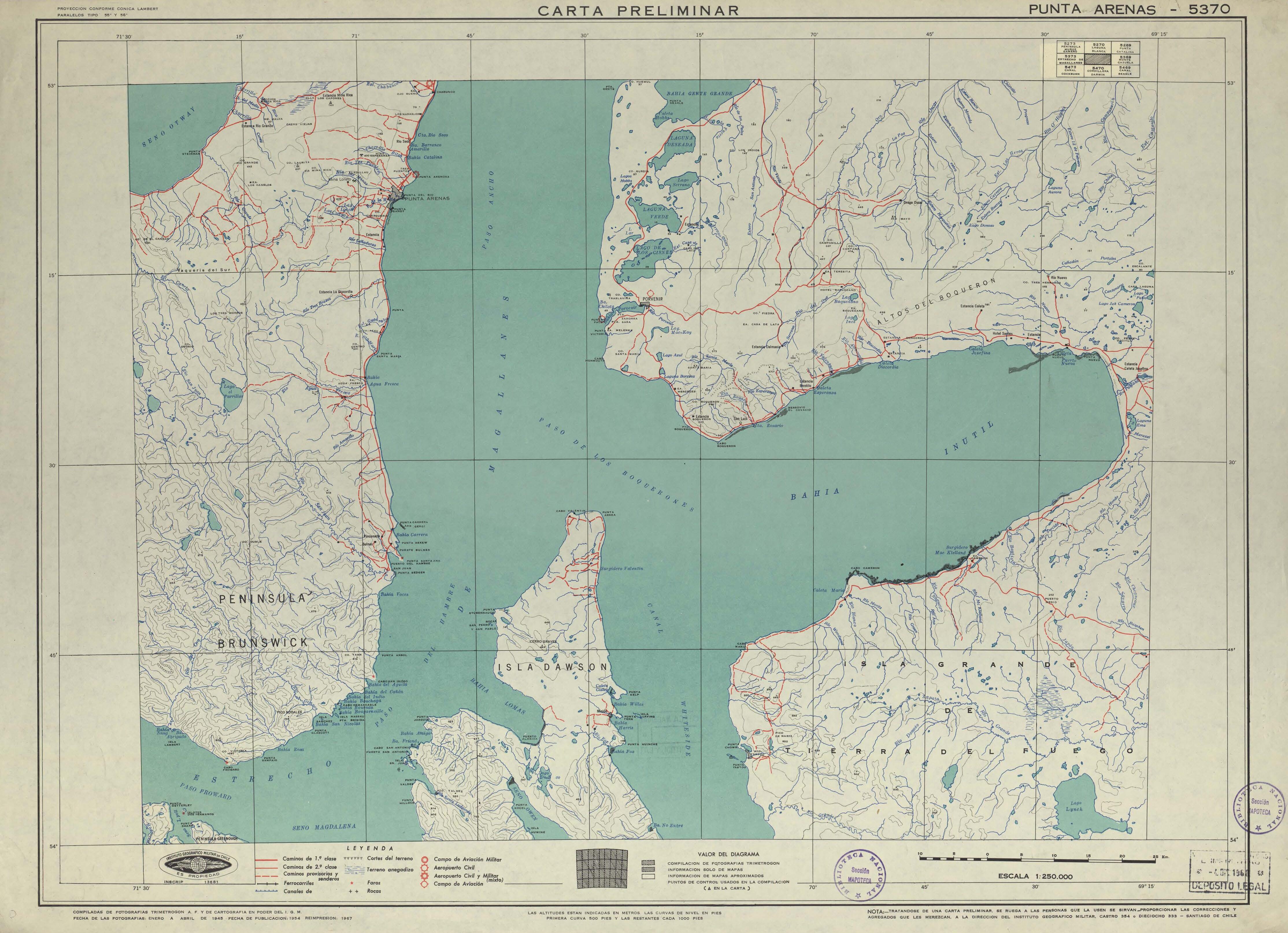
Español: Punta Arenas carta preliminar / [material cartográfico] : Instituto Geográfico Militar de Chile. Santiago : Instituto Geográfico Militar de Chile, 1954, (impresión 1967) 1 mapa : color ; 52 x 71 cm, en hoja 55 x 77 cm. . |
| Date | |
| Source | http://www.bibliotecanacionaldigital.gob.cl/bnd/631/w3-article-157099.html |
| Author | Punta Arenas carta preliminar / [material cartográfico] : Instituto Geográfico Militar de Chile. Santiago : Instituto Geográfico Militar de Chile, 1954, (impresión 1967) 1 mapa : color ; 52 x 71 cm, en hoja 55 x 77 cm. . |
Licensing[edit]
This file has fallen into the public domain according to Chilean copyright law (No. 17336 and its amendments). Nevertheless, its author and source must be acknowledged.
See here for the type of material that is in the public domain (patrimonio cultural común / common cultural heritage).
|

|
File history
Click on a date/time to view the file as it appeared at that time.
| Date/Time | Thumbnail | Dimensions | User | Comment | |
|---|---|---|---|---|---|
| current | 09:17, 24 September 2020 |  | 4,456 × 3,227 (1.17 MB) | Juan Villalobos (talk | contribs) | Uploaded a work by Punta Arenas carta preliminar / [material cartográfico] : Instituto Geográfico Militar de Chile. Santiago : Instituto Geográfico Militar de Chile, 1954, (impresión 1967) 1 mapa : color ; 52 x 71 cm, en hoja 55 x 77 cm. . from http://www.bibliotecanacionaldigital.gob.cl/bnd/631/w3-article-157099.html with UploadWizard |
You cannot overwrite this file.
File usage on Commons
The following 2 pages use this file:
- IGM-Chile
- File:MP0001229.pdf (file redirect)
File usage on other wikis
The following other wikis use this file:
- Usage on es.wikipedia.org
- Río Las Minas
- Río San Juan de la Posesión
- Laguna Parrillar
- Río Grande (Whiteside)
- Río Grande (Steinman)
- Río del Oro (Bahía San Felipe)
- Río del Oro (Bahía Snug)
- Río Oscar
- Lago Don Bosco
- Laguna Deseada
- Lago Serrano
- Lago de Los Cisnes
- Laguna Verde (Magallanes)
- Río McClelland
- Laguna Escondida (río Grande de Tierra del Fuego)
- Río Porvenir
- Laguna Lynch
- Río Nogueira
- Río Nuevo (Bahía Inútil)
- Río Discordia
- Río Rosario (Bahía Inútil)
- Río Santa María (Bahía Inútil)
- Arroyo de La Puerta
- Río de Los Palos
- Río Caleta
- Hidrografía de la isla Grande de Tierra del Fuego