File:ALTERATIONS AND ADDITIONS TO NORTH ELEVATION (PHOTOCOPY OF DRAWING) - Governors Island, Building No. 2, New York Harbor, Nolan Park near Barry and Andes Roads, New York, New York HABS NY,31-GOVI,4-3.tif
Jump to navigation
Jump to search

Size of this JPG preview of this TIF file: 755 × 600 pixels. Other resolutions: 302 × 240 pixels | 604 × 480 pixels | 967 × 768 pixels | 1,280 × 1,017 pixels | 2,560 × 2,034 pixels | 4,971 × 3,949 pixels.
Original file (4,971 × 3,949 pixels, file size: 18.72 MB, MIME type: image/tiff)
Captions
Captions
Add a one-line explanation of what this file represents
Summary[edit]
| ALTERATIONS AND ADDITIONS TO NORTH ELEVATION (PHOTOCOPY OF DRAWING) - Governors Island, Building No. 2, New York Harbor, Nolan Park near Barry and Andes Roads, New York, New York County, NY | ||||
|---|---|---|---|---|
| Title |
ALTERATIONS AND ADDITIONS TO NORTH ELEVATION (PHOTOCOPY OF DRAWING) - Governors Island, Building No. 2, New York Harbor, Nolan Park near Barry and Andes Roads, New York, New York County, NY |
|||
| Depicted place | New York; New York County; New York | |||
| Date | Documentation compiled after 1933 | |||
| Dimensions | 4 x 5 in. | |||
| Current location |
Library of Congress Prints and Photographs Division Washington, D.C. 20540 USA http://hdl.loc.gov/loc.pnp/pp.print |
|||
| Accession number |
HABS NY,31-GOVI,4-3 |
|||
| Credit line |
|
|||
| Notes |
|
|||
| References |
|
|||
| Source | https://www.loc.gov/pictures/item/ny1494.photos.118250p | |||
| Permission (Reusing this file) |
|
|||

| Object location | | View this and other nearby images on: OpenStreetMap |
|---|
File history
Click on a date/time to view the file as it appeared at that time.
| Date/Time | Thumbnail | Dimensions | User | Comment | |
|---|---|---|---|---|---|
| current | 18:08, 29 July 2014 | 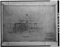 | 4,971 × 3,949 (18.72 MB) | Fæ (talk | contribs) | GWToolset: Creating mediafile for Fæ. HABS 24 July 2014 (2301:2600) |
You cannot overwrite this file.
File usage on Commons
The following page uses this file: