File:A map of Philadelphia and parts adjacent - with a perspective view of the State-House LOC 98690000.tif
Jump to navigation
Jump to search

Size of this JPG preview of this TIF file: 431 × 599 pixels. Other resolutions: 173 × 240 pixels | 345 × 480 pixels | 553 × 768 pixels | 737 × 1,024 pixels | 1,474 × 2,048 pixels | 4,633 × 6,438 pixels.
Original file (4,633 × 6,438 pixels, file size: 85.34 MB, MIME type: image/tiff)
Captions
Captions
Add a one-line explanation of what this file represents
Summary
[edit]| Description |
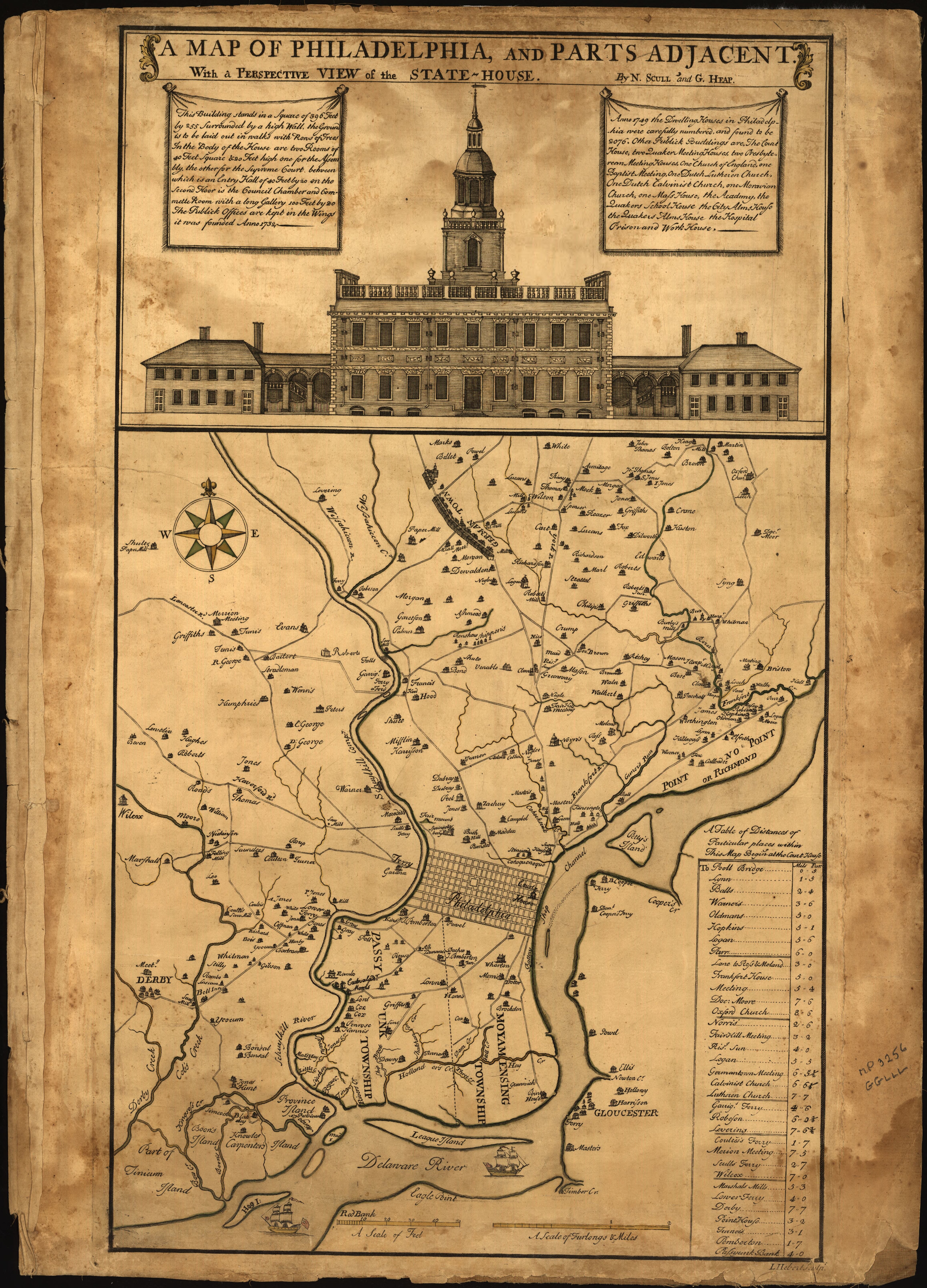
English: Rural buildings shown pictorially with occupants' names. First state of the 1st ed. (without the name "West Jersey" at lower right). Signed in ink on cloth backing: Alex. Stuart. Available also through the Library of Congress Web site as a raster image. Includes text, distance table, and ground-level view of the Statehouse (later Independence Hall). Purchased with funding support from J. Thomas Touchton, Mr. & Mrs. Isadore M. Scott, the Madison Council, and the Philip Lee Phillips Society; Richard B. Arkway Inc.; Sept. 1998. Vault Acquisitions control no.: 98-42 |
||
| Title | A map of Philadelphia and parts adjacent : with a perspective view of the State-House | ||
| Shelf ID | G3824.P5 1752 .S3 | ||
| Date | |||
| Source | https://www.loc.gov/item/98690000/ | ||
| Author | Scull, Nicholas; Heap, George; Hebert, L. | ||
| Permission (Reusing this file) |
|
||
| Other versions |
|
||
| Location | Philadelphia Region · Pennsylvania · Philadelphia · United States | ||
| Part of | Cities And Towns · Military Battles And Campaigns · Catalog · American Memory · Geography And Map Division · American Revolution And Its Era: Maps And Charts Of North America And The West Indies, 1750-1789 | ||
| Subject | Aerial Views · Maps · Philadelphia Region (Pa.) · Philadelphia (Pa.) · Philadelphia · United States · Pennsylvania · Early Works To 1800 · Independence Hall (Philadelphia, Pa.) · Philadelphia Region · Landowners |


Licensing
[edit]|
This is a faithful photographic reproduction of a two-dimensional, public domain work of art. The work of art itself is in the public domain for the following reason:
The official position taken by the Wikimedia Foundation is that "faithful reproductions of two-dimensional public domain works of art are public domain".
This photographic reproduction is therefore also considered to be in the public domain in the United States. In other jurisdictions, re-use of this content may be restricted; see Reuse of PD-Art photographs for details. | ||||
File history
Click on a date/time to view the file as it appeared at that time.
| Date/Time | Thumbnail | Dimensions | User | Comment | |
|---|---|---|---|---|---|
| current | 21:28, 6 September 2018 |  | 4,633 × 6,438 (85.34 MB) | Fæ (talk | contribs) | LOC Maps https://www.loc.gov/item/98690000/ #13966 |
You cannot overwrite this file.
File usage on Commons
The following page uses this file: