File:A map of that part of Pensylvania now the principle (sic) seat of war in America, wherein may be seen the situation of Philadelphia, Red Bank, Mud Island, & Germantown. LOC gm71000934.tif
Jump to navigation
Jump to search

Size of this JPG preview of this TIF file: 452 × 599 pixels. Other resolutions: 181 × 240 pixels | 362 × 480 pixels | 579 × 768 pixels | 773 × 1,024 pixels | 1,545 × 2,048 pixels | 3,749 × 4,968 pixels.
Original file (3,749 × 4,968 pixels, file size: 53.29 MB, MIME type: image/tiff)
Captions
Captions
Add a one-line explanation of what this file represents
Summary[edit]
| Description |
English: Scale 1:63,360; an in. to a mile. Relief shown pictorially. "Between the two lines that cross Philadelphia was the first plan of that city." LC copy has annotation "17" in upper right corner. Includes notes on attack on Fort Mifflin. Available also through the Library of Congress Web site as a raster image. Vault AACR2: 100; 651 |
||
| Title | A map of that part of Pensylvania now the principle [sic] seat of war in America, wherein may be seen the situation of Philadelphia, Red Bank, Mud Island, & Germantown. | ||
| Shelf ID | G3824.P5A1 1777 .S3 | ||
| Date | |||
| Source | https://www.loc.gov/item/gm71000934/ | ||
| Author | Scull, Nicholas; Jackson, L. | ||
| Permission (Reusing this file) |
|
||
| Other versions |
|
||
| Location | Philadelphia Region · Pennsylvania · United States | ||
| Part of | Military Battles And Campaigns · American Memory · Catalog · Geography And Map Division · American Revolution And Its Era: Maps And Charts Of North America And The West Indies, 1750-1789 | ||
| Subject | Pennsylvania · Philadelphia Region (Pa.) · United States · Maps · Early Works To 1800 · Philadelphia Region |

_seat_of_war_in_America,_wherein_may_be_seen_the_situation_of_Philadelphia,_Red_Bank,_Mud_Island,_%26_Germantown._LOC_gm71000934.jpg)
Licensing[edit]
|
This is a faithful photographic reproduction of a two-dimensional, public domain work of art. The work of art itself is in the public domain for the following reason:
The official position taken by the Wikimedia Foundation is that "faithful reproductions of two-dimensional public domain works of art are public domain".
This photographic reproduction is therefore also considered to be in the public domain in the United States. In other jurisdictions, re-use of this content may be restricted; see Reuse of PD-Art photographs for details. | ||||
File history
Click on a date/time to view the file as it appeared at that time.
| Date/Time | Thumbnail | Dimensions | User | Comment | |
|---|---|---|---|---|---|
| current | 06:15, 20 September 2018 | 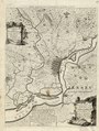 | 3,749 × 4,968 (53.29 MB) | Fæ (talk | contribs) | LOC Maps https://www.loc.gov/item/gm71000934/ #34281 |
You cannot overwrite this file.
File usage on Commons
The following page uses this file: