File:A portion of the Amistad National Recreation Area, outside Del Rio in Val Verde County, Texas LCCN2014630589.tif
Original file (7,273 × 4,854 pixels, file size: 202.04 MB, MIME type: image/tiff)
Captions
Summary
[edit]DescriptionA portion of the Amistad National Recreation Area, outside Del Rio in Val Verde County, Texas LCCN2014630589.tif |
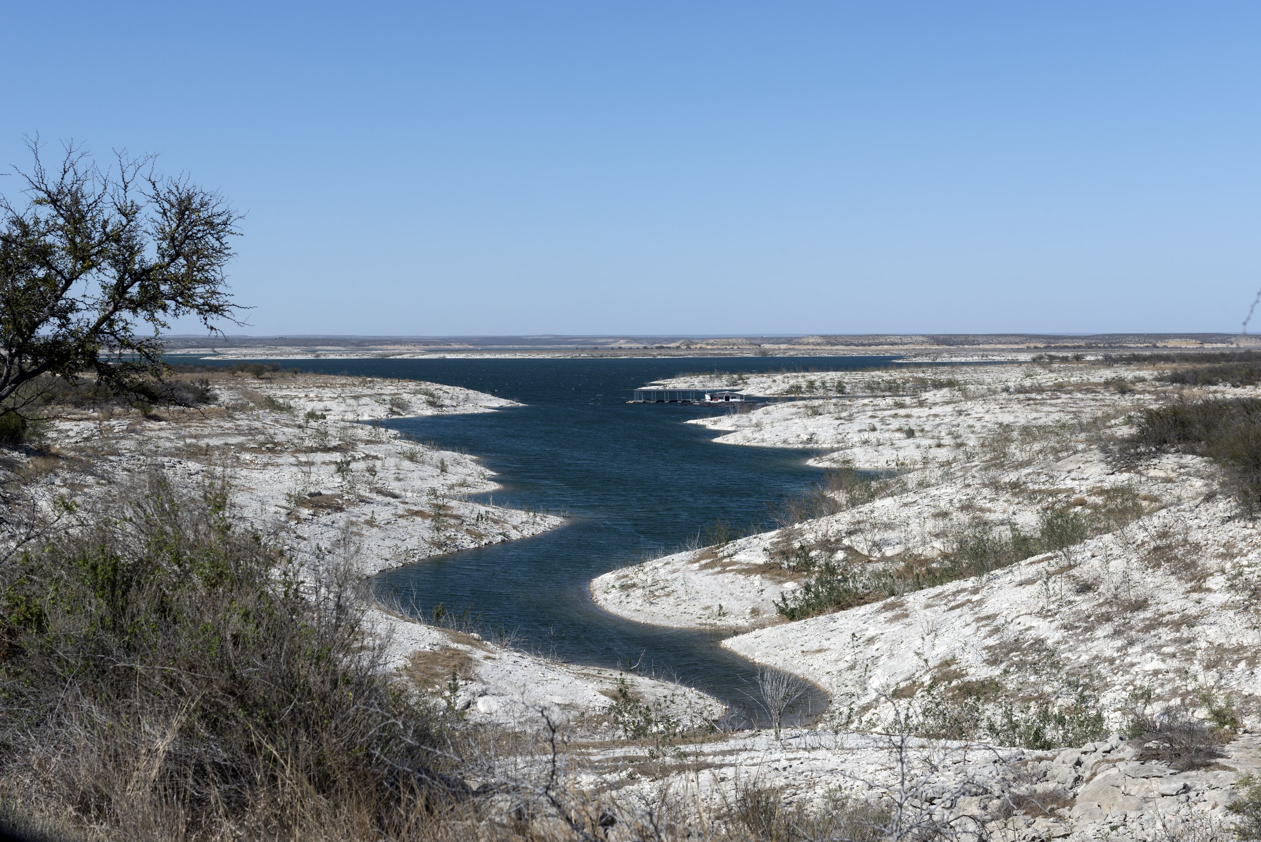
English: Title: A portion of the Amistad National Recreation Area, outside Del Rio in Val Verde County, Texas
Physical description: 1 photograph : digital, tiff file, color. Notes: Title, date, and keywords based on information provided by the photographer.; Credit line: The Lyda Hill Texas Collection of Photographs in Carol M. Highsmith's America Project, Library of Congress, Prints and Photographs Division.; Forms part of: Lyda Hill Texas Collection of Photographs in Carol M. Highsmith's America Project in the Carol M. Highsmith Archive.; Gift; The Lyda Hill Foundation; 2014; (DLC/PP-2014:054).; Managed by National Park Service,the area includes the Amistad Reservoir at the confluence of the Rio Grande, the Devils River, and the Pecos River. Amistad, Spanish for "friendship," refers broadly to the close relationship and shared history between Ciudad Acu±a and Del Rio. The waters of the recreation area are popular destinations for fishers and boaters. |
||||||||||||||||||||||||||
Date | Taken on 16 March 2014, 16:34 (according to Exif data) | ||||||||||||||||||||||||||
Source |
Library of Congress
|
||||||||||||||||||||||||||
Author |
creator QS:P170,Q5044454 |
||||||||||||||||||||||||||
Permission (Reusing this file) |
No known restrictions on publication.
|
Camera location | 29° 28′ 21.96″ N, 101° 01′ 33.23″ W | View this and other nearby images on: OpenStreetMap | 29.472768; -101.025898 |
---|
Licensing
[edit]Public domainPublic domainfalsefalse |
This work is from the Carol M. Highsmith Archive collection at the Library of Congress. According to the library, there are no known copyright restrictions on the use of this work. Carol M. Highsmith has stipulated that her photographs are in the public domain. Photographs of sculpture or other works of art may be restricted by the copyright of the artist; see Commons:FOP US#Artworks and sculptures for more information. |
File history
Click on a date/time to view the file as it appeared at that time.
Date/Time | Thumbnail | Dimensions | User | Comment | |
---|---|---|---|---|---|
current | 20:49, 5 September 2016 | 7,273 × 4,854 (202.04 MB) | Fæ (talk | contribs) | LOC 2014630589, Carol M. Highsmith collection. P220.10539 TIFF (202.0mb) |
You cannot overwrite this file.
File usage on Commons
There are no pages that use this file.
File usage on other wikis
The following other wikis use this file:
- Usage on fr.wikipedia.org
Metadata
This file contains additional information such as Exif metadata which may have been added by the digital camera, scanner, or software program used to create or digitize it. If the file has been modified from its original state, some details such as the timestamp may not fully reflect those of the original file. The timestamp is only as accurate as the clock in the camera, and it may be completely wrong.
Camera manufacturer | NIKON CORPORATION |
---|---|
Camera model | NIKON D800 |
Author | Photographer: Carol M. Highsmith |
Exposure time | 1/320 sec (0.003125) |
F-number | f/10 |
ISO speed rating | 100 |
Date and time of data generation | 16:34, 16 March 2014 |
Lens focal length | 55 mm |
Latitude | 29° 28′ 21.97″ N |
Longitude | 101° 1′ 33.23″ W |
Altitude | 353 meters above sea level |
Width | 7,273 px |
Height | 4,854 px |
Bits per component |
|
Compression scheme | Uncompressed |
Pixel composition | RGB |
Image data location | 31,488 |
Orientation | Normal |
Number of components | 3 |
Number of rows per strip | 4,854 |
Bytes per compressed strip | 211,818,852 |
Horizontal resolution | 300 dpi |
Vertical resolution | 300 dpi |
Data arrangement | chunky format |
Software used | Ver.1.02 |
File change date and time | 13:38, 18 March 2014 |
Exposure Program | Manual |
Exif version | 2.21 |
Date and time of digitizing | 16:34, 16 March 2014 |
APEX shutter speed | 8.321928 |
APEX aperture | 6.643856 |
APEX exposure bias | 0 |
Maximum land aperture | 3 APEX (f/2.83) |
Metering mode | Pattern |
Light source | Unknown |
Flash | Flash did not fire, compulsory flash suppression |
DateTimeOriginal subseconds | 6 |
Color space | Uncalibrated |
Focal plane X resolution | 2,048.4022216797 |
Focal plane Y resolution | 2,048.4022216797 |
Focal plane resolution unit | 3 |
Sensing method | One-chip color area sensor |
File source | Digital still camera |
Scene type | A directly photographed image |
Custom image processing | Normal process |
Exposure mode | Manual exposure |
White balance | Auto white balance |
Digital zoom ratio | 1 |
Focal length in 35 mm film | 55 mm |
Scene capture type | Standard |
Scene control | None |
Contrast | Normal |
Saturation | Normal |
Sharpness | Normal |
Subject distance range | Unknown |
GPS time (atomic clock) | 21:34 |
Satellites used for measurement | 08 |
Reference for direction of image | Magnetic direction |
Direction of image | 335.05 |
Geodetic survey data used | WGS 84 |
GPS date | 16 March 2014 |
GPS tag version | 2.3.0.0 |
Structured data
Items portrayed in this file
depicts
2014
29°28'21.965"N, 101°1'33.233"W
image/tiff
f4003b85f8f5b0424786e6da4cdca7088d8c6276
211,853,810 byte
4,854 pixel
7,273 pixel
- United States photographs taken on 2014-03-16
- Images from the Library of Congress
- Files with coordinates missing SDC location of creation
- Library of Congress-no known copyright restrictions
- PD-Highsmith
- Images uploaded by Fæ
- The Lyda Hill Texas Collection of Photographs in Carol M. Highsmith's America Project, Library of Congress, Prints and Photographs Division
- Lyda Hill Texas Collection of Photographs in Carol M. Highsmith's America Project in the Carol M. Highsmith Archive
- Photographs by Carol M. Highsmith
- Pages with maps