File:A survey of the roads of the United States of America LOC 84675230-3.tif
Jump to navigation
Jump to search

Size of this JPG preview of this TIF file: 439 × 599 pixels. Other resolutions: 176 × 240 pixels | 352 × 480 pixels | 563 × 768 pixels | 751 × 1,024 pixels | 1,774 × 2,420 pixels.
Original file (1,774 × 2,420 pixels, file size: 12.28 MB, MIME type: image/tiff)
Captions
Captions
Add a one-line explanation of what this file represents
Summary[edit]
| Description |
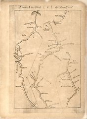
English: Relief shown by hachures. Orientation varies. Phillips, 1326 Maps no. 34-39 are believed to never have been engraved as they are wanting in all known copies. Available also through the Library of Congress Web site as a raster image. On original paper cover in manuscript ink: "Collis's plan of the roads throughout the United States." Accompanied by broadside: Proposals for publishing A survey of the roads of the United States of America / by Christopher Colles (conserved and bound in, 29 x 20 cm.). Additionally accompanied by manuscript title page for this atlas from the Peter Force Collection (on sheet 21 x 12 cm.) and additional page with manuscript notes by Peter Force and George H. Moore, dated 1846 (on sheet 21 x 13 cm.). These 2 sheets and exhibit card in envelope, in slipcase, housed in container with Copy 2. Conserved.
|
||
| Title | A survey of the roads of the United States of America | ||
| Shelf ID | G1201.P2 C6 1789 G1201.P2 C6 1789 Copy 2 Vault | ||
| Parent | https://www.loc.gov/resource/g3701pm.gct00276b/ | ||
| Sheet title | From New York (2) to Stratford | ||
| Date | |||
| Source | https://www.loc.gov/item/84675230/ | ||
| Author | Colles, Christopher; Tiebout, Cornelius | ||
| Permission (Reusing this file) |
|
||
| Other versions |
|
||
| Location | United States · Middle Atlantic States | ||
| Part of | American Memory · Catalog · Transportation And Communication · Geography And Map Division | ||
| Subject | Early Maps · Atlases · United States · Maps · Early Works To 1800 · Middle Atlantic States · Roads |


Licensing[edit]
|
This is a faithful photographic reproduction of a two-dimensional, public domain work of art. The work of art itself is in the public domain for the following reason:
The official position taken by the Wikimedia Foundation is that "faithful reproductions of two-dimensional public domain works of art are public domain".
This photographic reproduction is therefore also considered to be in the public domain in the United States. In other jurisdictions, re-use of this content may be restricted; see Reuse of PD-Art photographs for details. | ||||
File history
Click on a date/time to view the file as it appeared at that time.
| Date/Time | Thumbnail | Dimensions | User | Comment | |
|---|---|---|---|---|---|
| current | 12:25, 6 June 2018 |  | 1,774 × 2,420 (12.28 MB) | Fæ (talk | contribs) | LOC Maps multisheet https://www.loc.gov/item/84675230/ sheet 3 of 84 #13558 |
You cannot overwrite this file.
File usage on Commons
The following 2 pages use this file: