File:A topographical chart of the bay of Narraganset in the province of New England, with all the isles contained therein, among which Rhode Island and Connonicut have been particularly surveyed, shewing LOC 74692134.tif
Jump to navigation
Jump to search

Size of this JPG preview of this TIF file: 405 × 599 pixels. Other resolutions: 162 × 240 pixels | 324 × 480 pixels | 519 × 768 pixels | 692 × 1,024 pixels | 1,384 × 2,048 pixels | 7,819 × 11,569 pixels.
Original file (7,819 × 11,569 pixels, file size: 258.8 MB, MIME type: image/tiff)
Captions
Captions
Add a one-line explanation of what this file represents
Summary
[edit]| Warning | The original file is very high-resolution. It might not load properly or could cause your browser to freeze when opened at full size. |
|---|
| Description |
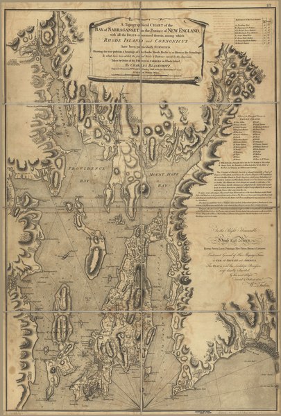
English: Scale ca. 1:50,000. Relief shown by hachures. Depths shown by soundings and form lines. Inscribed "To the Right Honourable Hugh Earl Percy ... with His Lordship's permission ... by ... Wm. Faden." Includes text, "References to the batteries," and "A list of the principal farms in Rhode Island." LC Maps of North America, 1750-1789, 1003 Available also through the Library of Congress Web site as a raster image. Vault AACR2: 100; 651/1; 650/2; 651/3; 700/1 |
||
| Title | A topographical chart of the bay of Narraganset in the province of New England, with all the isles contained therein, among which Rhode Island and Connonicut have been particularly surveyed, shewing the true position & bearings of the banks, shoals, rocks &c. as likewise the soundings: To which have been added the several works & batteries raised by the Americans. Taken by order of the principal farmers on Rhode Island. | ||
| Shelf ID | G3772.N3 1777 .B5 | ||
| Date | |||
| Source | https://www.loc.gov/item/74692134/ | ||
| Author | Blaskowitz, Charles; Faden, William | ||
| Permission (Reusing this file) |
|
||
| Other versions |
|
||
| Location | United States · Narragansett Bay · Rhode Island | ||
| Part of | Military Battles And Campaigns · American Memory · Catalog · Geography And Map Division · American Revolution And Its Era: Maps And Charts Of North America And The West Indies, 1750-1789 | ||
| Subject | Defenses · Nautical Charts · Narragansett Bay · Rhode Island · United States · Maps · Early Works To 1800 · Narragansett Bay (R.I.) |


Licensing
[edit]|
This is a faithful photographic reproduction of a two-dimensional, public domain work of art. The work of art itself is in the public domain for the following reason:
The official position taken by the Wikimedia Foundation is that "faithful reproductions of two-dimensional public domain works of art are public domain".
This photographic reproduction is therefore also considered to be in the public domain in the United States. In other jurisdictions, re-use of this content may be restricted; see Reuse of PD-Art photographs for details. | ||||
File history
Click on a date/time to view the file as it appeared at that time.
| Date/Time | Thumbnail | Dimensions | User | Comment | |
|---|---|---|---|---|---|
| current | 05:34, 31 July 2018 |  | 7,819 × 11,569 (258.8 MB) | Fæ (talk | contribs) | LOC Maps https://www.loc.gov/item/74692134/ #16743 |
You cannot overwrite this file.
File usage on Commons
The following page uses this file: