File:Actividad militar de Guerrero (1812-1817)-fr.svg
Jump to navigation
Jump to search

Size of this PNG preview of this SVG file: 798 × 482 pixels. Other resolutions: 320 × 193 pixels | 640 × 387 pixels | 1,024 × 619 pixels | 1,280 × 773 pixels | 2,560 × 1,546 pixels.
Original file (SVG file, nominally 798 × 482 pixels, file size: 404 KB)
Captions
Captions
Add a one-line explanation of what this file represents
| Description |
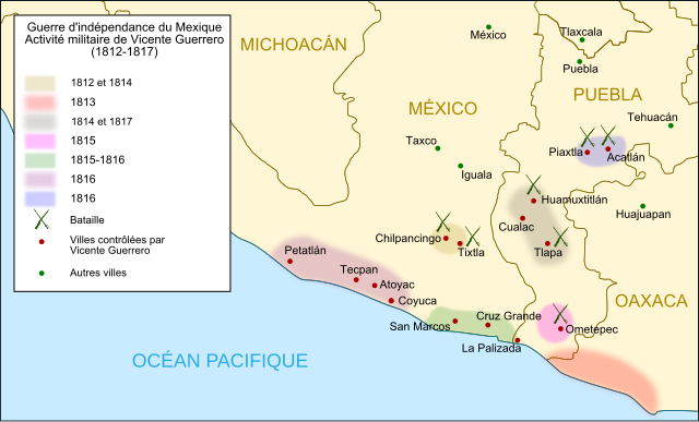
Français : Carte de l'activité militaire de Vicente Guerrero au cours de la guerre d'indépendance mexicaine entre 1812 et 1817.) English: Map of military activities of Vicente Guerrero during Mexican Independance War between 1812 and 1817. Español: Mapa de ubicación de las zonas donde estuvo activo Vicente Guerrero entre 1812 y 1817, como parte de los grupos insurgentes durante la Guerra de Independencia de México. Fuente: Sordo Cedeño, Reynaldo y María Julia Sierra Moncayo (2010), Atlas conmemorativo 1810-1910-2010, Siglo XXI-Senado de la República, México. |
||
| Date | (UTC) | ||
| Source | Image:Actividad militar de Guerrero (1812-1817).svg | ||
| Author | Yavidaxiu. Translation by Historicair | ||
| Permission (Reusing this file) |
I, the copyright holder of this work, hereby publish it under the following licenses:
This file is licensed under the Creative Commons Attribution 3.0 Unported license.
You may select the license of your choice. |
||
| Other versions |
.svg) |

-fr.svg)
|
This SVG file contains embedded text that can be translated into your language, using any capable SVG editor, text editor or the SVG Translate tool. For more information see: About translating SVG files. |
-fr.svg)
File history
Click on a date/time to view the file as it appeared at that time.
| Date/Time | Thumbnail | Dimensions | User | Comment | |
|---|---|---|---|---|---|
| current | 21:29, 19 August 2010 | | 798 × 482 (404 KB) | Historicair (talk | contribs) | fix type |
| 21:27, 19 August 2010 |  | 798 × 482 (290 KB) | Historicair (talk | contribs) | {{Information |Description={{fr|Carte de l'activité militaire de Vicente Guerrero au cours de la guerre d'indépendance mexicaine entre 1812 et 1817.)}} {{en|Map of military activities of Vicente Guerrero during Mexican Independance War between 1812 and |
You cannot overwrite this file.
File usage on Commons
The following 3 pages use this file:
-ru.svg)
.svg&redirect=no)
File usage on other wikis
The following other wikis use this file:
- Usage on fr.wikipedia.org
-fr.svg&oldid=781676777)