File:Acueducto del padre tembleque.jpg

Original file (1,249 × 832 pixels, file size: 224 KB, MIME type: image/jpeg)
Captions
Captions
Summary
[edit]
| Description |
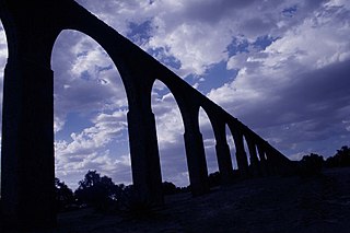
Español: Levantado a comienzos del siglo XVI, es la obra de ingeniería hidráulica más importante levantada durante ese siglo en el continente americano. Su arcada más conocida, la que atraviesa la barranca de Tepeyahualco, se ubica entre los límites del Estado de México y el Estado de Hidalgo. Comúnmente se le conoce como "Arcos de sitio" o "Acueducto de Zempoala", esta última designación ya que parte del acueducto pasa por ese municipio hidalguense.
Se sabe que la obra se levantó a instancias del Padre Fray Francisco de Tembleque, oriundo de Toledo, España, quien con un grupo de 400 indígenas al mando del maestro en cantería Juan Correa de Agüero decidió llevar a cabo tal empresa entre los años de 1543 y 1560 (no se conocen las fechas exactas del inicio y su conclusión) motivado por la escasez de agua en la región y por el acaparamiento de la poca que existía por parte de los colonos españoles. La obra tiene una longitud total de 48 kilómetros. Se origina en los manantiales de las faldas del volcán de Tecajete y cruza lomas, cerros, 3 barrancas, poblados y haciendas, hasta llegar a su destino final: La ciudad de Otumba, cabecera del municipio homónimo. Si bien se conocen por su arcada, más del 90 por ciento del acueducto corre bajo tierra, y solo un 3 por ciento pasa por la arquería que está conformada por 3 puentes; el porcentaje restante pasa a nivel del suelo. |
||
| Date | |||
| Source | Arcos Padre Tembleque | ||
| Author | MARTIN H J from TIZAYUCA, MEXICO | ||
| Permission (Reusing this file) |
This file is licensed under the Creative Commons Attribution 2.0 Generic license.
|
| Camera location | | View this and other nearby images on: OpenStreetMap |
|---|
Licensing
[edit]
- You are free:
- to share – to copy, distribute and transmit the work
- to remix – to adapt the work
- Under the following conditions:
- attribution – You must give appropriate credit, provide a link to the license, and indicate if changes were made. You may do so in any reasonable manner, but not in any way that suggests the licensor endorses you or your use.
| This image was originally posted to Flickr by Martínhj (México) at https://www.flickr.com/photos/11070180@N02/4569444895. It was reviewed on 16 October 2010 by FlickreviewR and was confirmed to be licensed under the terms of the cc-by-2.0. |
File history
Click on a date/time to view the file as it appeared at that time.
| Date/Time | Thumbnail | Dimensions | User | Comment | |
|---|---|---|---|---|---|
| current | 20:04, 13 November 2017 | | 1,249 × 832 (224 KB) | Hasenläufer (talk | contribs) | Removed watermark (LrMediaWiki 0.8.0, LR 7.0 Mac) |
| 16:56, 21 September 2015 |  | 1,245 × 827 (98 KB) | Sebastian Wallroth (talk | contribs) | Cropped 4 % horizontally and 6 % vertically using CropTool with precise mode. | |
| 21:16, 16 October 2010 |  | 1,302 × 884 (111 KB) | RubeHM (talk | contribs) | {{Information |Description={{es|1=Levantado a comienzos del siglo XVI, es la obra de ingeniería hidráulica más importante levantada durante ese siglo en el continente americano. Su arcada más conocida, la que atraviesa la barranca de Tepeyehualco, se |
You cannot overwrite this file.
File usage on Commons
There are no pages that use this file.
File usage on other wikis
The following other wikis use this file:
- Usage on be.wikipedia.org
- Usage on fr.wikipedia.org
- Usage on kk.wikipedia.org