File:Aerial view of Mesenich, Germany, on 25 January 1945 (312328805).jpg
Jump to navigation
Jump to search

Size of this preview: 600 × 599 pixels. Other resolutions: 240 × 240 pixels | 481 × 480 pixels | 769 × 768 pixels | 1,026 × 1,024 pixels | 2,051 × 2,048 pixels | 2,642 × 2,638 pixels.
Original file (2,642 × 2,638 pixels, file size: 6.77 MB, MIME type: image/jpeg)
Captions
Captions
Add a one-line explanation of what this file represents
Summary
[edit].jpg&action=edit§ion=1)
| Description |
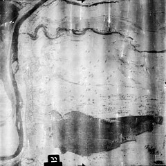
English: Aerial view of Mesenich, Germany, on 25 January 1945. At left ist the river Sauer/Sûre which is also the border between Germany and Luxembourg. The German village of Mesenich is in the left center. The rail line from Igel to Bitburg emerges in the lower right corner from the 827m long Igel-Mesenich tunnel. On the Luxembourg side, the line Ettelbruck-Grevenmacher (Prince Henri) is visible. |
|||
| Date | Taken on 25 January 1945 | |||
| Source |
|
|||
| Author | U.S. Army Air Forces Spot Number F11517, Sortie US31-4027, Exposure RSV-2128 |
| Camera location | | View this and other nearby images on: OpenStreetMap |
|---|
.jpg¶ms=049.734894_N_0006.515466_E_globe:Earth_type:camera__&language=en)
Licensing
[edit].jpg&action=edit§ion=2)
This image or file is a work of a U.S. Air Force Airman or employee, taken or made as part of that person's official duties. As a work of the U.S. federal government, the image or file is in the public domain in the United States.
|
 |
File history
Click on a date/time to view the file as it appeared at that time.
| Date/Time | Thumbnail | Dimensions | User | Comment | |
|---|---|---|---|---|---|
| current | 22:05, 23 February 2024 | | 2,642 × 2,638 (6.77 MB) | Cobatfor (talk | contribs) | == {{int:filedesc}} == {{Information |Description={{en|1=Aerial view of Mesenich, Germany, on 25 January 1945. At left ist the river Sauer/Sûre which is also the border between Germany and Luxembourg. The German village of Mesenich is in the left center. The rail line from Igel to Bitburg emerges in the lower right corner from the 827m long Igel-Mesenich tunnel. On the Luxembourg side, the line Ettelbruck-Grevenmacher (Prince Henri) is visible.}} |Source={{NARA-image|id=312328805}} |Date={{ta... |
You cannot overwrite this file.
File usage on Commons
The following page uses this file:
.jpg&oldid=855282723)