File:All american canal map.png
Jump to navigation
Jump to search
No higher resolution available.
All_american_canal_map.png (300 × 300 pixels, file size: 70 KB, MIME type: image/png)
Captions
Captions
Add a one-line explanation of what this file represents
Summary
[edit]
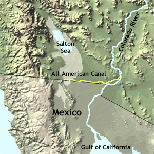
- English: Map of the All-American Canal — across the southeastern Colorado Desert, in Imperial County, Southern California.
- Also showing the Salton Sink with Salton Sea; and the lower Colorado River in the U.S. and Mexico.
Credits
[edit]
- Source: http://nationalatlas.gov/articles/agriculture/a_ivalley.html archive copy at the Wayback Machine
- License: Public domain (http://www-atlas.usgs.gov/help/faq.html#thirteen archive copy at the Wayback Machine)
This image is in the public domain in the United States because it only contains materials that originally came from the United States Geological Survey, an agency of the United States Department of the Interior. For more information, see the official USGS copyright policy.
|
Original upload log
[edit]
| Date/Time | Dimensions | User | Comment |
|---|---|---|---|
| 10 August 2007, 21:27:45 | 300 × 300 (60639 bytes) | Epolk (talk · contribs) | Desc: A map of the All-American Canal. Source: http://nationalatlas.gov/articles/agriculture/a_ivalley.html License: Public domain (http://www-atlas.usgs.gov/help/faq.html#thirteen) {{PD-USGov-USGS}} [[Maps of California]] [[Maps of canals]] |
File history
Click on a date/time to view the file as it appeared at that time.
| Date/Time | Thumbnail | Dimensions | User | Comment | |
|---|---|---|---|---|---|
| current | 11:15, 12 August 2014 | | 300 × 300 (70 KB) | GifTagger (talk | contribs) | Bot: Converting file to superior PNG file. (Source: All_american_canal_map.gif). This GIF was problematic due to non-greyscale color table. |
You cannot overwrite this file.
File usage on Commons
The following 2 pages use this file:
- File:All american canal map.gif (file redirect)
- Category:All-American Canal
File usage on other wikis
The following other wikis use this file:
- Usage on de.wikipedia.org
- Usage on en.wikipedia.org
- Usage on he.wikipedia.org
- Usage on ru.wikipedia.org
- Usage on www.wikidata.org