File:Alvin R. Bush Dam LOC 2005626839.tif
Jump to navigation
Jump to search

Size of this JPG preview of this TIF file: 800 × 455 pixels. Other resolutions: 320 × 182 pixels | 640 × 364 pixels | 1,024 × 582 pixels | 1,280 × 727 pixels | 2,560 × 1,455 pixels | 9,588 × 5,448 pixels.
Original file (9,588 × 5,448 pixels, file size: 149.45 MB, MIME type: image/tiff)
Captions
Captions
Add a one-line explanation of what this file represents
Summary[edit]
| Description |
English: Also covers Kettle Creek State Park (Pa.). Oriented with north toward the upper right. Includes text, statistical table, and col. ill. Insets: West Branch Susquehanna River Basin [location map] -- Vicinity map -- Flood pool-937 msl. Text and col. ill. on verso. Available also through the Library of Congress Web site as a raster image. |
||
| Title | Alvin R. Bush Dam | ||
| Shelf ID | G3822.A53E63 2003 .U5 | ||
| Date | |||
| Source | https://www.loc.gov/item/2005626839/ | ||
| Author | United States. Army. Corps Of Engineers. Baltimore District | ||
| Permission (Reusing this file) |
|
||
| Other versions |
|
||
| Location | Kettle Creek State Park · Pennsylvania · Alvin R. Bush Dam Region · United States · Kettle Creek State Park. · Alvin R. Bush Dam Region. | ||
| Part of | American Memory · General Maps · Catalog · Geography And Map Division | ||
| Subject | Floodplains · Kettle Creek State Park · Pennsylvania · Alvin R. Bush Dam Region · United States · Maps · Recreation Areas · Tourist Maps · Outdoor Recreation · Kettle Creek State Park (Pa.) · Alvin R. Bush Dam Region (Pa.) |


Licensing[edit]
| This work is from the Library of Congress. According to the library, there are no known copyright restrictions on the use of this work. |  |
File history
Click on a date/time to view the file as it appeared at that time.
| Date/Time | Thumbnail | Dimensions | User | Comment | |
|---|---|---|---|---|---|
| current | 03:56, 10 June 2018 | 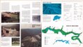 | 9,588 × 5,448 (149.45 MB) | Fæ (talk | contribs) | LOC Maps https://www.loc.gov/item/2005626839/ #25433 |
You cannot overwrite this file.
File usage on Commons
The following page uses this file: