File:Ancient waymark^ - geograph.org.uk - 1248664.jpg
Jump to navigation
Jump to search
Size of this preview: 414 × 599 pixels. Other resolutions: 166 × 240 pixels | 442 × 640 pixels.
Original file (442 × 640 pixels, file size: 100 KB, MIME type: image/jpeg)
Captions
Captions
Add a one-line explanation of what this file represents
Summary
[edit]
| Description |
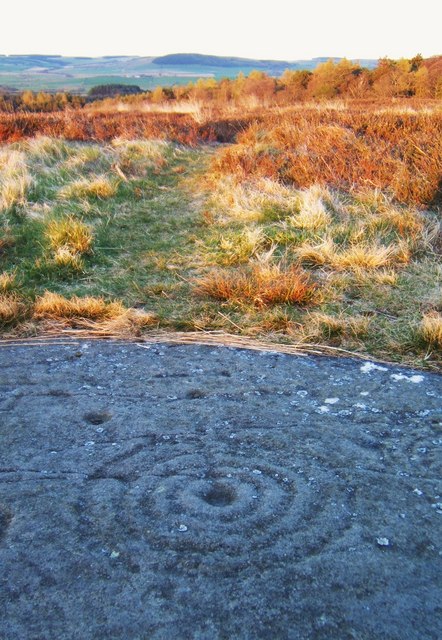
English: Ancient waymark? One of many cup and ring marks on Weetwood Moor. A suggestion of the purpose of these ancient carvings is that the radial line indicated direction to the next important point of a journey, with the size and number of rings representing the distance. (See also 1248687.) The radial line here points towards Doddington Moor (about 3.5km NNW) where there are many more cup and ring marks, and signs of ancient settlement including a stone circle 905513. |
| Date | |
| Source | From geograph.org.uk |
| Author | Barbara Carr |
| Attribution (required by the license) | Barbara Carr / Ancient waymark? / |
| Camera location | | View this and other nearby images on: OpenStreetMap |
|---|
_heading:67.00&language=en)
| Object location | | View this and other nearby images on: OpenStreetMap |
|---|
_heading:67.00&language=en)
Licensing
[edit]

|
This image was taken from the Geograph project collection. See this photograph's page on the Geograph website for the photographer's contact details. The copyright on this image is owned by Barbara Carr and is licensed for reuse under the Creative Commons Attribution-ShareAlike 2.0 license.
|
This file is licensed under the Creative Commons Attribution-Share Alike 2.0 Generic license.
Attribution: Barbara Carr
- You are free:
- to share – to copy, distribute and transmit the work
- to remix – to adapt the work
- Under the following conditions:
- attribution – You must give appropriate credit, provide a link to the license, and indicate if changes were made. You may do so in any reasonable manner, but not in any way that suggests the licensor endorses you or your use.
- share alike – If you remix, transform, or build upon the material, you must distribute your contributions under the same or compatible license as the original.
File history
Click on a date/time to view the file as it appeared at that time.
| Date/Time | Thumbnail | Dimensions | User | Comment | |
|---|---|---|---|---|---|
| current | 15:51, 26 February 2011 | | 442 × 640 (100 KB) | GeographBot (talk | contribs) | == {{int:filedesc}} == {{Information |description={{en|1=Ancient waymark? One of many cup and ring marks on Weetwood Moor. A suggestion of the purpose of these ancient carvings is that the radial line indicated direction to the next important point of a j |
You cannot overwrite this file.
File usage on Commons
There are no pages that use this file.
File usage on other wikis
The following other wikis use this file:
- Usage on en.wikipedia.org