File:Approaches of A. of P. to Fredericksburg. LOC 99446528.tif
Jump to navigation
Jump to search

Size of this JPG preview of this TIF file: 733 × 600 pixels. Other resolutions: 294 × 240 pixels | 587 × 480 pixels | 939 × 768 pixels | 1,252 × 1,024 pixels | 2,504 × 2,048 pixels | 5,059 × 4,138 pixels.
Original file (5,059 × 4,138 pixels, file size: 59.89 MB, MIME type: image/tiff)
Captions
Captions
Add a one-line explanation of what this file represents
Summary
[edit]| Description |
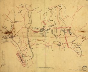
English: Shows "Genl. Hd Qrs.," routes of approach of the 2nd, 3rd, 5th and 6th Corps, roads, railroad, towns, drainage, and houses and names of residents. Relief shown by shading. Title from verso of map. Staining at central left and right edges of sheet. LC Civil War Maps (2nd ed.), 555 Available also through the Library of Congress web site as raster image. |
||
| Title | Approaches of A. of P. to Fredericksburg. | ||
| Shelf ID | G3884.F7S5 1862 .U5 | ||
| Date | |||
| Source | https://www.loc.gov/item/99446528/ | ||
| Author | United States. Army Of The Potomac | ||
| Permission (Reusing this file) |
|
||
| Other versions |
|
||
| Location | United States · Virginia · Fredericksburg Region | ||
| Part of | Military Battles And Campaigns · American Memory · Civil War Maps · Catalog · Geography And Map Division | ||
| Subject | Maps, Manuscript · Fredericksburg Region (Va.) · Virginia · Civil War · Fredericksburg Region · United States · Maps · Landowners · History |


Licensing
[edit]|
This is a faithful photographic reproduction of a two-dimensional, public domain work of art. The work of art itself is in the public domain for the following reason:
The official position taken by the Wikimedia Foundation is that "faithful reproductions of two-dimensional public domain works of art are public domain".
This photographic reproduction is therefore also considered to be in the public domain in the United States. In other jurisdictions, re-use of this content may be restricted; see Reuse of PD-Art photographs for details. | ||||
File history
Click on a date/time to view the file as it appeared at that time.
| Date/Time | Thumbnail | Dimensions | User | Comment | |
|---|---|---|---|---|---|
| current | 10:50, 20 May 2018 |  | 5,059 × 4,138 (59.89 MB) | Fæ (talk | contribs) | LOC Maps https://www.loc.gov/item/99446528/ #187 |
You cannot overwrite this file.
File usage on Commons
The following page uses this file: