File:Aquitani tribes map-fr.svg
跳转到导航
跳转到搜索

此SVG文件的PNG预览的大小:702 × 600像素。 其他分辨率:281 × 240像素 | 562 × 480像素 | 899 × 768像素 | 1,199 × 1,024像素 | 2,398 × 2,048像素 | 878 × 750像素。
原始文件 (SVG文件,尺寸为878 × 750像素,文件大小:1.26 MB)
说明
说明
添加一行文字以描述该文件所表现的内容

摘要
[编辑]| 描述 |
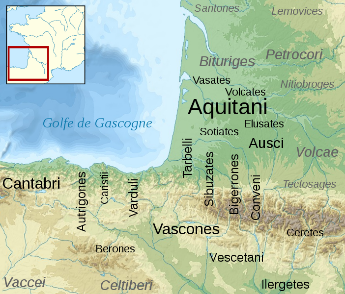
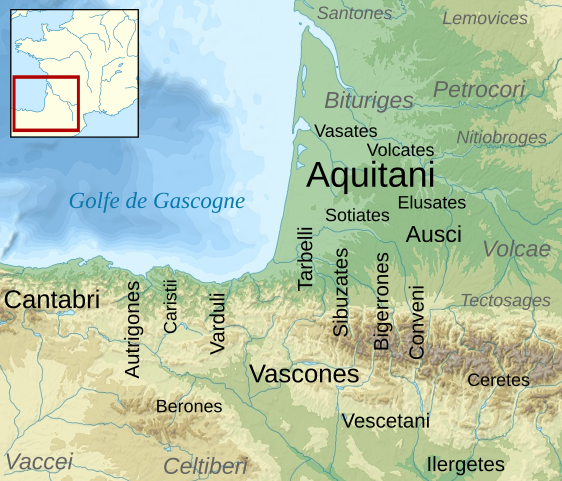
English: Map of the Aquitani and surrounding tribes in early Roman times.
Français : Carte des peuples de la Gaule Aquitaine au début de l'époque romaine.
|
||
| 日期 | |||
| 来源 |
|
||
| 作者 | Sémhur | ||
| 其他版本 | |||
| 署名 (由许可协议要求) | © Sémhur / Wikimedia Commons / | ||
| SVG | W3C-validity not checked.
|
||
| Graphic Lab |

| 相机位置 | | 在以下服务上查看本图像和附近其他图像: OpenStreetMap |
|---|
许可协议
[编辑]
我,本作品著作权人,特此采用以下许可协议发表本作品:
| 非营利著作权:本艺术作品是自由的,您可以依据自由艺术作品许可协议的条款传播和/或修改本艺术作品。您可以在Copyleft Attitude网站或其他网站找到该许可协议的样本。 |
- 您可以自由地:
- 共享 – 复制、发行并传播本作品
- 修改 – 改编作品
- 惟须遵守下列条件:
- 署名 – 您必须对作品进行署名,提供授权条款的链接,并说明是否对原始内容进行了更改。您可以用任何合理的方式来署名,但不得以任何方式表明许可人认可您或您的使用。
- 相同方式共享 – 如果您再混合、转换或者基于本作品进行创作,您必须以与原先许可协议相同或相兼容的许可协议分发您贡献的作品。
您可以选择您需要的许可协议。
原始上传日志
[编辑]
This image is a derivative work of the following images:
- File:France_map_Lambert-93_topographic-blank.svg licensed with Cc-by-sa-3.0,2.5,2.0,1.0, GFDL
- 2008-11-13T17:24:53Z Sting 2000x1898 (1639447 Bytes) + boundary for Channel Islands ; - canals
- 2008-10-01T04:59:44Z Sting 2000x1898 (1682809 Bytes) == Summary == {{Location|46|15|00|N|02|06|00|E|scale:10000000}} {{Information |Description={{en|Blank topographic map of [[:en:France|France]] in the official Lambert-93 projection.}} {{fr|Carte topographique vierge de la [[
- File:Aquitani.gif licensed with PD-self
- 2007-01-25T14:16:29Z Michel BUZE 481x393 (10166 Bytes) {{Information |Description= *Author: [[:en:User:Sugaar|Sugaar]] *Sources: various (ultimately [[:en:Strabo]] and [[:en:Pliny]]) *Based on [[:en::Image:Basque tribes.gif]] (the only diference is that it tags the Aquitani confe
- File:Blank_map_of_Gaul_1st_century_BC.svg licensed with Cc-by-sa-2.5,2.0,1.0, GFDL
- 2007-07-07T19:30:39Z Historicair 755x784 (45078 Bytes) {{Information |Description={{fr}}Carte vierge de la Gaule au Ier siècle avant JC {{en}}Blank map of Gaul 1st century BC. |Source=[[:Image:Caesar's Campaigns in Gaul, 1st century BC.gif]] |Date=07/07/2007 |Author=~~~~ |Permis
Uploaded with derivativeFX
文件历史
点击某个日期/时间查看对应时刻的文件。
| 日期/时间 | 缩略图 | 大小 | 用户 | 备注 | |
|---|---|---|---|---|---|
| 当前 | 2009年2月17日 (二) 15:46 | | 878 × 750(1.26 MB) | Sémhur(留言 | 贡献) | {{Information |Description= {{en|Map of the Aquitani and surrounding tribes in early Roman times. * Black: pre-Indoeuropean tribes. * Grey: Celtic tribes. ''Note: the macro-ethnicity of some of the tribes is disputed.''}} {{fr|Carte des peuples de la Ga |
您不可以覆盖此文件。
文件用途
以下6个页面使用本文件:
全域文件用途
以下其他wiki使用此文件:
- an.wikipedia.org上的用途
- azb.wikipedia.org上的用途
- az.wikipedia.org上的用途
- bg.wikipedia.org上的用途
- br.wikipedia.org上的用途
- ca.wikipedia.org上的用途
- de.wikipedia.org上的用途
- el.wikipedia.org上的用途
- en.wikipedia.org上的用途
- en.wiktionary.org上的用途
- eo.wikipedia.org上的用途
- eu.wikipedia.org上的用途
- fi.wikipedia.org上的用途
- fr.wikipedia.org上的用途
查看此文件的更多全域用途。