File:Ashby station - geograph.org.uk - 1524462.jpg
Jump to navigation
Jump to search
No higher resolution available.
Ashby_station_-_geograph.org.uk_-_1524462.jpg (640 × 480 pixels, file size: 101 KB, MIME type: image/jpeg)
Captions
Captions
Add a one-line explanation of what this file represents
Summary
[edit]
| Description |
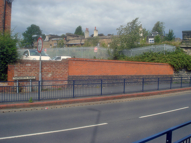
English: Ashby station. Looking across Tamworth Road to the railway station behind the fence. This station was built for the Midland Railway in 1849 on the Burton-to-Leicester line. Its refined single-storey classical form, with pillared portico, shallow bay windows, and square end pavilions were designed by R. Chaplin, who designed the spa buildings in the town. Now closed and recent efforts to reopen the goods-only line to passengers have failed.
http://en.wikipedia.org/wiki/Ashby_de_la_Zouch_railway_station |
| Date | |
| Source | From geograph.org.uk |
| Author | Trevor Rickard |
| Attribution (required by the license) | Trevor Rickard / Ashby station / |
| Camera location | | View this and other nearby images on: OpenStreetMap |
|---|
_heading:337.00&language=en)
| Object location | | View this and other nearby images on: OpenStreetMap |
|---|
_heading:337.00&language=en)
Licensing
[edit]

|
This image was taken from the Geograph project collection. See this photograph's page on the Geograph website for the photographer's contact details. The copyright on this image is owned by Trevor Rickard and is licensed for reuse under the Creative Commons Attribution-ShareAlike 2.0 license.
|
This file is licensed under the Creative Commons Attribution-Share Alike 2.0 Generic license.
Attribution: Trevor Rickard
- You are free:
- to share – to copy, distribute and transmit the work
- to remix – to adapt the work
- Under the following conditions:
- attribution – You must give appropriate credit, provide a link to the license, and indicate if changes were made. You may do so in any reasonable manner, but not in any way that suggests the licensor endorses you or your use.
- share alike – If you remix, transform, or build upon the material, you must distribute your contributions under the same or compatible license as the original.
File history
Click on a date/time to view the file as it appeared at that time.
| Date/Time | Thumbnail | Dimensions | User | Comment | |
|---|---|---|---|---|---|
| current | 02:37, 3 March 2011 | | 640 × 480 (101 KB) | GeographBot (talk | contribs) | == {{int:filedesc}} == {{Information |description={{en|1=Ashby station Looking across Tamworth Road to the railway station behind the fence. This station was built for the Midland Railway in 1849 on the Burton-to-Leicester line. Its refined single-storey |
You cannot overwrite this file.
File usage on Commons
There are no pages that use this file.