File:Asia 200bc.jpg
Naviqasiyaya keç
Axtarışa keç

Sınaq göstərişi ölçüsü: 800 × 468 piksel. Digər ölçülər: 320 × 187 piksel | 640 × 374 piksel | 1.024 × 599 piksel | 1.280 × 748 piksel | 2.037 × 1.191 piksel.
Faylın orijinalı (2.037 × 1.191 piksel, fayl həcmi: 763 KB, MIME növü: image/jpeg)
Captions
Captions
Add a one-line explanation of what this file represents
Xülasə[redaktə]

|
This historical map image could be re-created using vector graphics as an SVG file. This has several advantages; see Commons:Media for cleanup for more information. If an SVG form of this image is available, please upload it and afterwards replace this template with
{{vector version available|new image name}}.
It is recommended to name the SVG file “Asia 200bc.svg”—then the template Vector version available (or Vva) does not need the new image name parameter. |


| İzah |
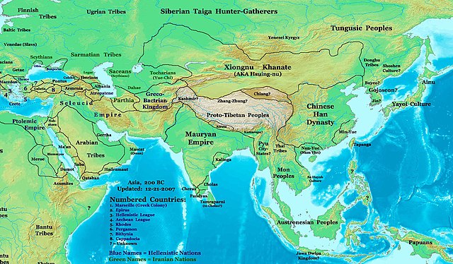
English: This image is a zoomed-in version of Eastern Hemisphere in 200 BC.
 |
| Tarix | 22 oktyabr 2007 (original upload date) |
| Mənbə | Öz işi. URL: http://www.ThomasLessman.com/History/images/East-Hem_200bc.jpg. |
| Müəllif | Thomas A. Lessman (Talessman at ingilis Vikipediya) |
| İcazə (Faylın təkrar istifadəsi) |
Image was created by me (Thomas Lessman) based on map of Eastern Hemisphere in 200 BC. Image is free for public and/or educational use. I would appreciate a mention if this image is used elsewhere. If anyone is interested in helping further this work, please contact Thomas Lessman at talessman@yis.us. |
| Other Historical Maps by Thomas Lessman | Eastern Hemisphere: |
Lisenziya[redaktə]
Talessman at ingilis Vikipediya, the copyright holder of this work, hereby publishes it under the following licenses:

|
Bu sənədi GNU Azad Sənədləşdirmə Lisenziyası, Versiya 1.2 və ya Azad Proqram Fondu tərəfindən nəşr olunan hər hansı sonrakı versiya şərtlərinə əsasən dəyişməz bölmələr, ön qapaq mətnləri və arxa qapaq mətnləri olmadan köçürmək, yayımlamaq və / və ya dəyişdirmək üçün icazə verilir; Lisenziyanın bir nüsxəsi GNU Azad Sənədləşdirmə Lisenziyası adlı hissəyə daxil edilmişdir. |
This file is licensed under the Creative Commons Attribution 3.0 Unported license.
İstinad: Talessman at ingilis Vikipediya
- Azadsınız:
- paylaşmaq – əsəri köçürmək, paylamaq və ötürmək üçün
- remiks etmək – əsəri adaptasiya etmək
- Aşağıdakı şərtlərə riayət etməklə:
- istinad – Müvafiq kredit verməlisiniz, lisenziyaya bir keçid verməlisiniz və dəyişikliklərin olub olmadığını bildirməlisiniz. Bunu hər hansı bir ağlabatan şəkildə edə bilərsiniz, ancaq lisenziyalaşdırıcının sizi və ya istifadənizi təsdiqləməsini təklif edən bir şəkildə deyil.
İstədiyiniz lisenziyanı seçə bilərsiniz.
Orijinal yükləmə gündəliyi[redaktə]
The original description page was here. All following user names refer to en.wikipedia.
- 2007-10-22 15:40 Talessman 1639×840×8 (435686 bytes) Author: Thomas A. Lessman. Source URL: http://www.ThomasLessman.com/History/images/East-Hem_200bc.jpg. Image was created by me (Thomas Lessman) based on map of Eastern Hemisphere in 200bc. Image is free for public and/or educational use. I would appreciat
Faylın tarixçəsi
Faylın əvvəlki versiyasını görmək üçün gün/tarix bölməsindəki tarixlərə klikləyin.
| Tarix/Vaxt | Kiçik şəkil | Ölçülər | İstifadəçi | Şərh | |
|---|---|---|---|---|---|
| indiki | 09:38, 3 aprel 2021 | | 2.037 × 1.191 (763 KB) | Glennznl (müzakirə | töhfələr) | Reverted to version as of 14:28, 19 June 2020 (UTC) Unsourced |
| 02:56, 27 mart 2021 |  | 1.024 × 599 (362 KB) | Enola gay0 (müzakirə | töhfələr) | Reverted to version as of 05:16, 1 February 2019 (UTC) discussions needed | |
| 14:28, 19 iyun 2020 |  | 2.037 × 1.191 (763 KB) | Austronesier (müzakirə | töhfələr) | Reverted to version as of 20:49, 22 January 2008 (UTC) according to established historiography. | |
| 05:16, 1 fevral 2019 |  | 1.024 × 599 (362 KB) | Enola gay0 (müzakirə | töhfələr) | Reverted to version as of 05:45, 3 September 2016 (UTC) | |
| 14:23, 17 yanvar 2019 |  | 2.037 × 1.191 (763 KB) | Ibrahim Muizzuddin (müzakirə | töhfələr) | Reverted to version as of 20:49, 22 January 2008 (UTC) according to established historiography | |
| 05:45, 3 sentyabr 2016 |  | 1.024 × 599 (362 KB) | JournalmanManila (müzakirə | töhfələr) | The depiction of sea-waves on the lid places this Manunggul jar (Philippine burial Jar) in the Sa Huỳnh culture pottery tradition. These are people that migrated in an East to West migration from the Borneo-Palawan area to Southern Vietnam. | |
| 20:49, 22 yanvar 2008 |  | 2.037 × 1.191 (763 KB) | Talessman (müzakirə | töhfələr) | Updated info, added numbered legend, etc. | |
| 19:44, 17 dekabr 2007 |  | 1.639 × 840 (425 KB) | File Upload Bot (Magnus Manske) (müzakirə | töhfələr) | {{BotMoveToCommons|en.wikipedia}} {{Information |Description={{en|This image is a zoomed-in version of [http://en.wikipedia.org/wiki/Image:East-Hem_200bc_web-sm.jpg Eastern Hemisphere in 200 BC]. [[:en:Image:East-Hem_200bc_web-sm.jpg|thumb|300px|left|Eas |
Siz bu faylı yenidən yükləyə bilməzsiniz.
Fayl keçidləri
Aşağıdakı 3 səhifə bu faylı istifadə edir:
Faylın qlobal istifadəsi
Bu fayl aşağıdakı vikilərdə istifadə olunur:
- af.wikipedia.org layihəsində istifadəsi
- als.wikipedia.org layihəsində istifadəsi
- azb.wikipedia.org layihəsində istifadəsi
- az.wikipedia.org layihəsində istifadəsi
- ca.wikipedia.org layihəsində istifadəsi
- de.wikipedia.org layihəsində istifadəsi
- en.wikipedia.org layihəsində istifadəsi
- es.wikipedia.org layihəsində istifadəsi
- fa.wikipedia.org layihəsində istifadəsi
- fr.wikipedia.org layihəsində istifadəsi
- he.wikipedia.org layihəsində istifadəsi
- incubator.wikimedia.org layihəsində istifadəsi
- it.wikipedia.org layihəsində istifadəsi
- ja.wikipedia.org layihəsində istifadəsi
- ka.wikipedia.org layihəsində istifadəsi
- ko.wikipedia.org layihəsində istifadəsi
- lt.wikipedia.org layihəsində istifadəsi
- pnb.wikipedia.org layihəsində istifadəsi
- ro.wikipedia.org layihəsində istifadəsi
- ru.wikipedia.org layihəsində istifadəsi
- sl.wikipedia.org layihəsində istifadəsi
- sv.wikipedia.org layihəsində istifadəsi
- tr.wikipedia.org layihəsində istifadəsi
- uk.wikipedia.org layihəsində istifadəsi
- ur.wikipedia.org layihəsində istifadəsi
- vi.wikipedia.org layihəsində istifadəsi
Bu faylın qlobal istifadəsinə baxın.
Kateqoriyalar:
- Maps of 3rd-century BC India
- Maps of 3rd-century BC Asia
- Maps of 2nd-century BC Asia
- Maps of the history of the Middle East
- Maps of the history of China
- Maps of 2nd-century BC India
- Maps of the history of Vietnam
- Maps of the Greco-Bactrian Kingdom
- Maps of the Mauryan Empire
- Maps of Parthia
- Details of the history maps by Thomas A. Lessmann