File:Atlas Beudeker-C9E10 126 26X-EMVDA, vulgo EMBDEN Vrbs Frisiae orientalis primaria.jpeg

Original file (5,500 × 4,133 pixels, file size: 4.88 MB, MIME type: image/jpeg)
Captions
Captions
Summary
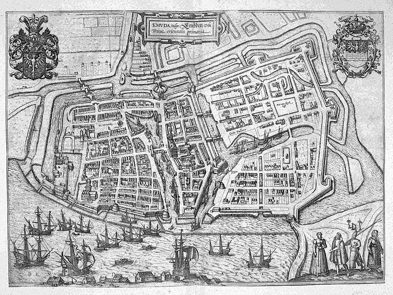
[edit]| EMVDA, vulgo EMBDEN Vrbs Frisiae orientalis primaria
( |
||||||
|---|---|---|---|---|---|---|
| Author |
Publisher: Gerard Braun en Frans Hogenberg |
|||||
| Title |
EMVDA, vulgo EMBDEN Vrbs Frisiae orientalis primaria |
|||||
| Object type | ||||||
| Description |
Nederlands: Deze stadsplattegrond van Embden werd in 1572 in Keulen gepubliceerd. De kaart is opgenomen in de beroemde stedenatlas Civitates orbis terrarum van
Georg Braun (1541-1622) en Frans Hogenberg (1535-1590). De Civitates was één van de bestsellers van het laatste kwart van de 16de eeuw. Originele afdrukken van deze kaart waren tot aan het einde van de 18de eeuw algemeen verkrijgbaar. De koperplaten van de atlas waren in 1653 in handen van de Amsterdamse uitgever Jan Janssonius (1588-1664) gekomen. Hij gebruikte de platen voor zijn eigen stedenatlas uit 1657. Na zijn dood wisselden de platen tot het einde van de 18de eeuw regelmatig van eigenaar.English: This city plan of Embden was published in Cologne in 1572. The map was included in the town atlas Civitates orbis terrarum by Georg Braun
(1541-1622) and Frans Hogenberg (1535-1590). The Civitates was one of the bestsellers of the last quarter of the 16th century. The Amsterdam publisher Jan Janssonius (1588-1664) bought the copper plates of the atlas in 1653. He used the plates for his own town atlas from 1657. After his death, the plates were sold several times until the end of the 18th century. |
|||||
| Date | 1572 | |||||
| Medium |
Nederlands: Kopergravure
English: copper engraving print |
|||||
| Dimensions | 35 x 48 cm | |||||
| Collection | ||||||
| Place of creation | Keulen | |||||
| Notes | C9E10 126_26X | |||||
| Related persons | Georg Braun - Frans Hogenberg - Jan Janssonius | |||||
| Depicted locations | Germany - Embden | |||||
| Source/Photographer |
Source page at the Geheugen van Nederland / Memory of the Netherlands website
|
|||||
| Permission (Reusing this file) |
|
|||||


File history
Click on a date/time to view the file as it appeared at that time.
| Date/Time | Thumbnail | Dimensions | User | Comment | |
|---|---|---|---|---|---|
| current | 13:40, 16 July 2015 | | 5,500 × 4,133 (4.88 MB) | OlafJanssen (talk | contribs) | GWToolset: Creating mediafile for OlafJanssen. |
You cannot overwrite this file.
File usage on Commons
The following page uses this file: