File:Ayr terminus railway station (site), Ayrshire (geograph 6165142).jpg
Jump to navigation
Jump to search

Size of this preview: 800 × 600 pixels. Other resolutions: 320 × 240 pixels | 640 × 480 pixels | 1,024 × 768 pixels | 1,280 × 960 pixels | 1,600 × 1,200 pixels.
Original file (1,600 × 1,200 pixels, file size: 323 KB, MIME type: image/jpeg)
Captions
Captions
Add a one-line explanation of what this file represents
Summary[edit]
,_Ayrshire_(geograph_6165142).jpg&action=edit§ion=1)
| Description |
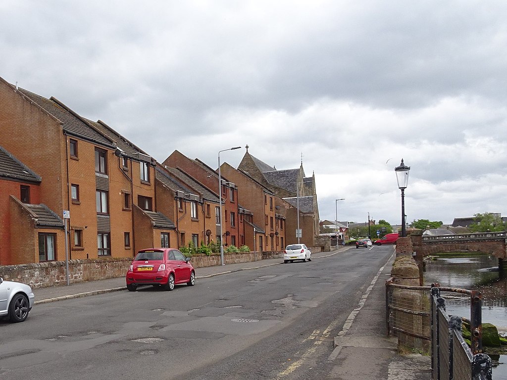
English: Ayr terminus railway station (site), Ayrshire Opened in 1839 by the Glasgow, Paisley, Kilmarnock & Ayr Railway, later part of the Glasgow & South Western Railway, as the terminus of its line. This station fronting North Harbour Street closed to passengers in 1857 a few months after a new Ayr station had opened on the current site (initially called 'Ayr Townhead') - see NS3421 : Ayr railway station, Ayrshire. The terminus continued in existence as a goods station and in 1899 a hole was cut through the building to extend one track across the river to serve the south quays of Ayr harbour. It crossed the road on a level crossing just beyond where the red car is. The goods station closed c.1970 and was demolished c.1979. The decking was removed from the bridge around the same time leaving just the stone piers across the River Ayr as any clue there was once a railway station on this site. The site has since been redeveloped for housing with a supermarket out of sight behind. |
| Date | |
| Source | From geograph.org.uk |
| Author | Nigel Thompson |
| Permission (Reusing this file) |
Creative Commons Attribution Share-alike license 2.0 |
| Attribution (required by the license) | Nigel Thompson / Ayr terminus railway station (site), Ayrshire / |
.jpg)
| Camera location | | View this and other nearby images on: OpenStreetMap |
|---|
,_Ayrshire_(geograph_6165142).jpg¶ms=055.465993_N_-004.632727_E_globe:Earth_type:camera_source:geograph-osgb36(NS33662228)_heading:90.00&language=en)
| Object location | | View this and other nearby images on: OpenStreetMap |
|---|
,_Ayrshire_(geograph_6165142).jpg¶ms=055.466010_N_-004.632090_E_globe:Earth_class:object_type:object_source:geograph-osgb36(NS33702228)_heading:90.00&language=en)
Licensing[edit]
,_Ayrshire_(geograph_6165142).jpg&action=edit§ion=2)

|
This image was taken from the Geograph project collection. See this photograph's page on the Geograph website for the photographer's contact details. The copyright on this image is owned by Nigel Thompson and is licensed for reuse under the Creative Commons Attribution-ShareAlike 2.0 license.
|
This file is licensed under the Creative Commons Attribution-Share Alike 2.0 Generic license.
Attribution: Nigel Thompson
- You are free:
- to share – to copy, distribute and transmit the work
- to remix – to adapt the work
- Under the following conditions:
- attribution – You must give appropriate credit, provide a link to the license, and indicate if changes were made. You may do so in any reasonable manner, but not in any way that suggests the licensor endorses you or your use.
- share alike – If you remix, transform, or build upon the material, you must distribute your contributions under the same or compatible license as the original.
File history
Click on a date/time to view the file as it appeared at that time.
| Date/Time | Thumbnail | Dimensions | User | Comment | |
|---|---|---|---|---|---|
| current | 13:56, 5 January 2020 | | 1,600 × 1,200 (323 KB) | Lamberhurst (talk | contribs) | Transferred from geograph.co.uk using [https://tools.wmflabs.org/geograph2commons/ geograph2commons] |
You cannot overwrite this file.
File usage on Commons
The following page uses this file:
File usage on other wikis
The following other wikis use this file:
- Usage on en.wikipedia.org
,_Ayrshire_(geograph_6165142).jpg&oldid=809494546)