File:Ayre Sound, Start Point, Sanday - geograph.org.uk - 1070199.jpg
Jump to navigation
Jump to search
No higher resolution available.
Ayre_Sound,_Start_Point,_Sanday_-_geograph.org.uk_-_1070199.jpg (640 × 410 pixels, file size: 63 KB, MIME type: image/jpeg)
Captions
Captions
Add a one-line explanation of what this file represents
Summary
[edit]
| Description |
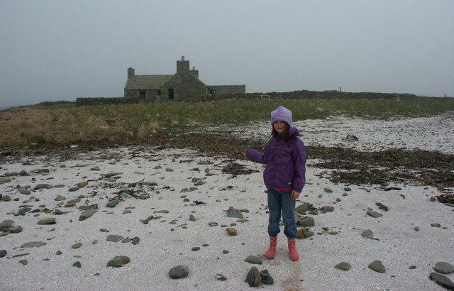
English: Ayre Sound, Start Point, Sanday The strandline behind Sophie marks the limit of most high tides. Where she is standing floods, cutting off the island behind, and Start Point lighthouse.We didn't get to the lighthouse, because once we reached the marram behind her, she was worried that the tide would flood in, cutting us off for the night. Back to the car then. |
| Date | |
| Source | From geograph.org.uk |
| Author | Ian Balcombe |
| Attribution (required by the license) | Ian Balcombe / Ayre Sound, Start Point, Sanday / |
| Camera location | | View this and other nearby images on: OpenStreetMap |
|---|
_heading:90.00&language=en)
| Object location | | View this and other nearby images on: OpenStreetMap |
|---|
_heading:90.00&language=en)
Licensing
[edit]

|
This image was taken from the Geograph project collection. See this photograph's page on the Geograph website for the photographer's contact details. The copyright on this image is owned by Ian Balcombe and is licensed for reuse under the Creative Commons Attribution-ShareAlike 2.0 license.
|
This file is licensed under the Creative Commons Attribution-Share Alike 2.0 Generic license.
Attribution: Ian Balcombe
- You are free:
- to share – to copy, distribute and transmit the work
- to remix – to adapt the work
- Under the following conditions:
- attribution – You must give appropriate credit, provide a link to the license, and indicate if changes were made. You may do so in any reasonable manner, but not in any way that suggests the licensor endorses you or your use.
- share alike – If you remix, transform, or build upon the material, you must distribute your contributions under the same or compatible license as the original.
File history
Click on a date/time to view the file as it appeared at that time.
| Date/Time | Thumbnail | Dimensions | User | Comment | |
|---|---|---|---|---|---|
| current | 06:42, 24 February 2011 | | 640 × 410 (63 KB) | GeographBot (talk | contribs) | == {{int:filedesc}} == {{Information |description={{en|1=Ayre Sound, Start Point, Sanday The strandline behind Sophie marks the limit of most high tides. Where she is standing floods, cutting off the island behind, and Start Point lighthouse.We didn't get |
You cannot overwrite this file.
File usage on Commons
There are no pages that use this file.