File:Azores-map.png
Jump to navigation
Jump to search

Size of this preview: 800 × 489 pixels. Other resolutions: 320 × 195 pixels | 640 × 391 pixels | 1,024 × 625 pixels | 1,280 × 782 pixels | 2,960 × 1,808 pixels.
Original file (2,960 × 1,808 pixels, file size: 358 KB, MIME type: image/png)
Captions
Captions
Add a one-line explanation of what this file represents

|
This map image could be re-created using vector graphics as an SVG file. This has several advantages; see Commons:Media for cleanup for more information. If an SVG form of this image is available, please upload it and afterwards replace this template with
{{vector version available|new image name}}.
It is recommended to name the SVG file “Azores-map.svg”—then the template Vector version available (or Vva) does not need the new image name parameter. |
Summary[edit]
| Description |
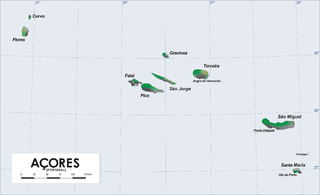
Map of Azores Islands (Portugal)
|
| Date | 21 March 2006 (original upload date) |
| Source | No machine-readable source provided. Own work assumed (based on copyright claims). |
| Author | No machine-readable author provided. Varp~commonswiki assumed (based on copyright claims). |
derivative works[edit]
Derivative works of this file: Azores Base Map.png
Licensing[edit]
| I, the copyright holder of this work, release this work into the public domain. This applies worldwide. In some countries this may not be legally possible; if so: I grant anyone the right to use this work for any purpose, without any conditions, unless such conditions are required by law. |
File history
Click on a date/time to view the file as it appeared at that time.
| Date/Time | Thumbnail | Dimensions | User | Comment | |
|---|---|---|---|---|---|
| current | 17:00, 7 November 2016 | | 2,960 × 1,808 (358 KB) | NordNordWest (talk | contribs) | + 75 km |
| 15:01, 8 April 2006 |  | 2,960 × 1,808 (380 KB) | Varp~commonswiki (talk | contribs) | ||
| 12:33, 7 April 2006 |  | 2,960 × 1,808 (379 KB) | Varp~commonswiki (talk | contribs) | ||
| 18:54, 2 April 2006 |  | 2,960 × 1,808 (329 KB) | Varp~commonswiki (talk | contribs) | ||
| 19:40, 26 March 2006 |  | 2,960 × 1,808 (319 KB) | Varp~commonswiki (talk | contribs) | ||
| 12:27, 21 March 2006 |  | 2,960 × 1,808 (318 KB) | Varp~commonswiki (talk | contribs) | *Map of Azores Islands (Portugal) *drawn by varp |
You cannot overwrite this file.
File usage
The following 16 pages use this file:
- Atlas of Portugal
- Atlas of the Azores
- Azores
- Império Português
- User:Chinggis6/Favorites
- File:Azores-map-zh.png
- File:Azores Base Map.png
- File:Azores Horta.png
- Category:Airports in the Azores
- Category:Animals of the Azores
- Category:Azores
- Category:Flora of the Azores
- Category:Islands of the Azores
- Category:Lighthouses in the Azores
- Category:People from the Azores
- Category:Transport in the Azores
Global file usage
The following other wikis use this file:
- Usage on af.wikipedia.org
- Usage on als.wikipedia.org
- Usage on az.wikipedia.org
- Usage on bg.wikipedia.org
- Usage on br.wikipedia.org
- Usage on bs.wikipedia.org
- Usage on ca.wikipedia.org
- Usage on de.wikipedia.org
- Usage on el.wikipedia.org
- Usage on el.wikivoyage.org
- Usage on en.wikipedia.org
- Usage on en.wikiversity.org
- Usage on en.wikivoyage.org
- Usage on es.wikipedia.org
- Usage on et.wikipedia.org
- Usage on fi.wikivoyage.org
- Usage on frr.wikipedia.org
- Usage on fr.wikipedia.org
- Usage on ga.wikipedia.org
- Usage on gl.wikipedia.org
- Usage on he.wikivoyage.org
- Usage on hsb.wikipedia.org
- Usage on hu.wikipedia.org
- Usage on it.wikipedia.org
- Usage on ja.wikipedia.org
- Usage on lb.wikipedia.org
- Usage on lt.wikipedia.org
- Usage on mr.wikipedia.org
- Usage on nl.wikipedia.org
- Usage on pl.wiktionary.org
- Usage on pt.wikipedia.org
- Usage on ru.wikipedia.org
- Usage on ru.wikivoyage.org
- Usage on simple.wikipedia.org
- Usage on sl.wikipedia.org
- Usage on sq.wikipedia.org
- Usage on sv.wikipedia.org
- Usage on ur.wikipedia.org
View more global usage of this file.