File:BLACK CANYON ROAD BRIDGE, NORTH FRONT. - Black Canyon Road Bridge, Spanning Santa Ysabel Creek at intersection of Black Canyon and Sutherland Dam Roads, Ramona, San Diego County HAER CAL,37-RAMO.V,1-2.tif
Jump to navigation
Jump to search

Size of this JPG preview of this TIF file: 747 × 600 pixels. Other resolutions: 299 × 240 pixels | 598 × 480 pixels | 957 × 768 pixels | 1,276 × 1,024 pixels | 2,551 × 2,048 pixels | 5,214 × 4,186 pixels.
Original file (5,214 × 4,186 pixels, file size: 20.82 MB, MIME type: image/tiff)
Captions
Captions
Add a one-line explanation of what this file represents
Summary[edit]
| BLACK CANYON ROAD BRIDGE, NORTH FRONT. - Black Canyon Road Bridge, Spanning Santa Ysabel Creek at intersection of Black Canyon and Sutherland Dam Roads, Ramona, San Diego County, CA | ||||
|---|---|---|---|---|
| Photographer |
Related names:
|
|||
| Title |
BLACK CANYON ROAD BRIDGE, NORTH FRONT. - Black Canyon Road Bridge, Spanning Santa Ysabel Creek at intersection of Black Canyon and Sutherland Dam Roads, Ramona, San Diego County, CA |
|||
| Depicted place | California; San Diego County; Ramona | |||
| Date | Documentation compiled after 1968 | |||
| Dimensions | 4 x 5 in. | |||
| Current location |
Library of Congress Prints and Photographs Division Washington, D.C. 20540 USA http://hdl.loc.gov/loc.pnp/pp.print |
|||
| Accession number |
HAER CAL,37-RAMO.V,1-2 |
|||
| Credit line |
|
|||
| Notes |
|
|||
| Source | https://www.loc.gov/pictures/item/ca2640.photos.190974p | |||
| Permission (Reusing this file) |
|
|||

| Object location | | View this and other nearby images on: OpenStreetMap |
|---|
File history
Click on a date/time to view the file as it appeared at that time.
| Date/Time | Thumbnail | Dimensions | User | Comment | |
|---|---|---|---|---|---|
| current | 13:35, 7 July 2014 | 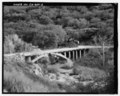 | 5,214 × 4,186 (20.82 MB) | Fæ (talk | contribs) | GWToolset: Creating mediafile for Fæ. HABS 05 July 2014 (401:500) |
You cannot overwrite this file.
File usage on Commons
The following 2 pages use this file:
File usage on other wikis
The following other wikis use this file:
- Usage on www.wikidata.org