File:Bagratuni Armenia 1000-fr.svg
跳至導覽
跳至搜尋

此 SVG 檔案的 PNG 預覽的大小:800 × 470 像素。 其他解析度:320 × 188 像素 | 640 × 376 像素 | 1,024 × 601 像素 | 1,280 × 751 像素 | 2,560 × 1,503 像素 | 2,717 × 1,595 像素。
原始檔案 (SVG 檔案,表面大小:2,717 × 1,595 像素,檔案大小:815 KB)
說明
說明
添加單行說明來描述出檔案所代表的內容
摘要
[編輯]| 描述 |
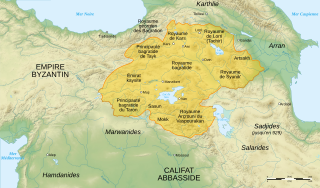
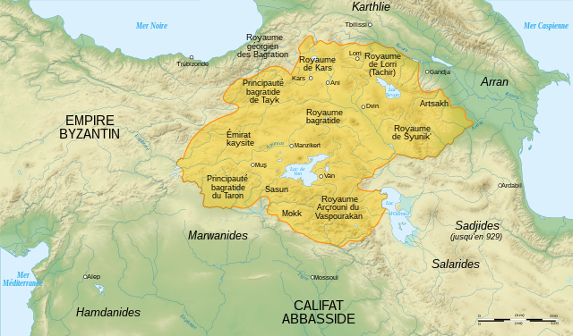
English: Map of Bagratuni Armenia, around the year 1000 AD., with French labels. (original map by G. A. Bournoutian from «A Concise History of the Armenian People», map 15, page 147) Français : Carte de l'Arménie bagratide vers l'an mille, . |
||
| 日期 | |||
| 來源 |
English: Data:
Softwares used :
Geographical data :
Français : 自己的作品. Sources :
Logiciels utilisés :
Autres données :
|
||
| 作者 | Sémhur | ||
| 其他版本 |
[]
|
||
| 姓名標示 (由许可协议要求) | © Sémhur / Wikimedia Commons / | ||
| SVG | W3C-validity not checked.
|
||
| Atelier graphique |


| 拍攝地點 | | 位於此地的本圖片與其他圖片: OpenStreetMap |
|---|
授權條款
[編輯]
我,本作品的著作權持有者,決定用以下授權條款發佈本作品:
| 公共版權:本藝術作品是自由的,您可以依據自由藝術作品許可協議的條款傳播和/或修改本藝術作品。您可以在Copyleft Attitude網站或其他網站找到該許可協議的樣本。 |
This file is licensed under the Creative Commons Attribution-Share Alike Attribution-Share Alike 4.0 International, 3.0 Unported, 2.5 Generic, 2.0 Generic and 1.0 Generic license.
- 您可以自由:
- 分享 – 複製、發佈和傳播本作品
- 重新修改 – 創作演繹作品
- 惟需遵照下列條件:
- 姓名標示 – 您必須指名出正確的製作者,和提供授權條款的連結,以及表示是否有對內容上做出變更。您可以用任何合理的方式來行動,但不得以任何方式表明授權條款是對您許可或是由您所使用。
- 相同方式分享 – 如果您利用本素材進行再混合、轉換或創作,您必須基於如同原先的相同或兼容的條款,來分布您的貢獻成品。
您可以選擇您需要的授權條款。
檔案歷史
點選日期/時間以檢視該時間的檔案版本。
| 日期/時間 | 縮圖 | 尺寸 | 用戶 | 備註 | |
|---|---|---|---|---|---|
| 目前 | 2021年4月20日 (二) 16:22 | | 2,717 × 1,595(815 KB) | Εὐθυμένης(對話 | 貢獻) | File uploaded using svgtranslate tool (https://svgtranslate.toolforge.org/). Added translation for el. |
| 2016年3月19日 (六) 09:41 |  | 2,717 × 1,595(775 KB) | Taivo(對話 | 貢獻) | repeatedly uploaded unsourced version | |
| 2016年3月17日 (四) 23:00 |  | 2,717 × 1,595(717 KB) | Georgiano(對話 | 貢獻) | 1) https://fr.wikipedia.org/wiki/Royaume_des_Kartvels 2) check out land titles of Bagratuni dynasty 3) during VIII-X century Tao (historical region) was part of Kingdom of the Kartvels. before removing my update, add... | |
| 2007年12月26日 (三) 18:57 |  | 2,717 × 1,595(775 KB) | Sémhur(對話 | 貢獻) | {{Information |Description= {{en| French map of Bagratuni Armenia, around the year 1000 AD.}} {{fr| Carte en français de l'Arménie bagratide, vers l'an mille.}} |Source=Travail personnel. {{clr}} Sources : * Fond de carte : [http://www2.jpl.nasa.gov/srt |
無法覆蓋此檔案。
檔案用途
下列11個頁面有用到此檔案:
- User:Chumwa/OgreBot/Potential transport maps/2016 March 11-20
- User:Jaqeli/Georgia
- User:Kareyac/Armenia/2016 March 11-20
- File:BagratuniArmenie1000.png
- File:Bagratuni Armenia 1000-ar.svg
- File:Bagratuni Armenia 1000-en.svg
- File:Bagratuni Armenia 1000-fr.svg
- File:Bagratuni Armenia 1000-hy.svg
- File:Bagratuni Armenia 1000-pt.svg
- File:Bagratuni Armenia 1000-tr.svg
- Template:Other Versions/Bagratuni Armenia 1000
全域檔案使用狀況
以下其他 wiki 使用了這個檔案:
- ce.wikipedia.org 的使用狀況
- el.wikipedia.org 的使用狀況
- fr.wikipedia.org 的使用狀況
- Arménie
- Années 990
- Kars
- Bagratides
- Grégoire de Narek
- Histoire de l'Arménie médiévale
- Horomos
- Achot Ier d'Arménie
- Taron (Arménie)
- Vaspourakan
- Utilisateur:Hayastan07/Architecture arménienne
- Wikipédia:Atelier graphique/Cartes/Archives/janvier 2008
- Chronologie de l'Arménie
- Royaume de Lorri
- Miniature arménienne
- Wikipédia:Atelier graphique/Cartes/Archives/mars 2009
- Histoire de l'Arménie
- Conquête musulmane de l'Arménie
- it.wikipedia.org 的使用狀況
- pcd.wikipedia.org 的使用狀況
- ru.wikipedia.org 的使用狀況
- uk.wikipedia.org 的使用狀況
- zh.wikipedia.org 的使用狀況