File:Balkans-ethnic (1861).jpg
跳转到导航
跳转到搜索

本预览的尺寸:742 × 599像素。 其他分辨率:297 × 240像素 | 594 × 480像素 | 951 × 768像素 | 1,268 × 1,024像素 | 2,536 × 2,048像素 | 6,280 × 5,072像素。
原始文件 (6,280 × 5,072像素,文件大小:3.98 MB,MIME类型:image/jpeg)
说明
说明
添加一行文字以描述该文件所表现的内容
Albania and Kosovo
摘要[编辑]
| 描述 |
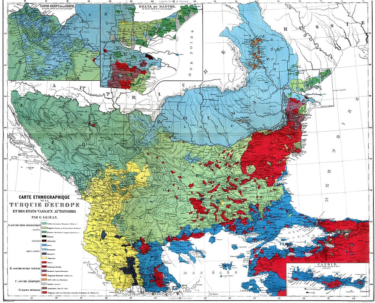
English: Guillaume Lejean's Ethnic map of European Turkey and its vassal states. Български: Етнографска карта на Гийом Лежан от Ethnographie de la Turquie d'Europe, 1861. Français : Carte ethnigraphique de la Turquie d'Europe et des etats vassaux autonomes. Par Guillaume Lejean, 1861. Deutsch: Ethnische Karte der Europäischen Türkei und deren autonomen Vassalenstaaten. Von Guillaume Lejean, 1861. Română: Harta etnică a Turciei europene şi a statelor sale vasale autonome. Autor: Guillaume Lejean, 1861. |
|||||||||||||||||
| 日期 | ||||||||||||||||||
| 来源 | Ethnographie de la Turquie d'Europe | |||||||||||||||||
| 作者 |
|
|||||||||||||||||
| 其他版本 |
此文件衍生的作品: |
|||||||||||||||||

.jpg&action=edit§ion=1)
_(2).jpg)
许可协议[编辑]
.jpg&action=edit§ion=2)
本图像属于公有领域。因为它是纯粹扫描或影印自一个已处于公有领域的原件或类似的预期不会受到版权保护的扫描或影印件。其原件因以下原因处于公有领域:
本标签主要用于该扫描件有可能使用任何增强功能(如亮度、对比度、色彩调整、锐利化等),而这些增强功能无法达到原创性而无法产生版权的情形下使用。而该标签也能使用在无法判定本扫描件使用任何增强功能,以及已知使用增强功能但没有充分证据时。对于采取原始忠实扫描而不使用增强功能的照片,可以适当采用{{PD-old}}标签取代。对于本标签的使用方法,参见共享资源:何时使用PD-Scan标签。  | ||||
文件历史
点击某个日期/时间查看对应时刻的文件。
| 日期/时间 | 缩略图 | 大小 | 用户 | 备注 | |
|---|---|---|---|---|---|
| 当前 | 2011年1月29日 (六) 19:04 | | 6,280 × 5,072(3.98 MB) | Tfts(留言 | 贡献) | Reverted to version as of 19:53, 3 December 2009 |
| 2011年1月28日 (五) 23:10 |  | 683 × 547(104 KB) | Ollios(留言 | 贡献) | Edremit Bay | |
| 2009年12月3日 (四) 19:53 |  | 6,280 × 5,072(3.98 MB) | Alex:D(留言 | 贡献) | cleaned | |
| 2007年11月15日 (四) 19:53 |  | 6,280 × 5,072(3.86 MB) | Olahus(留言 | 贡献) | ||
| 2007年11月2日 (五) 11:29 |  | 3,156 × 3,204(2.34 MB) | Olahus(留言 | 贡献) | {{Information |Description=Ethnic map of the Balkans (1861) |Source= |Date=1861 |Author=G. Lejean |Permission= |other_versions= }} == Licensing == {{PD-old}} |
您不可以覆盖此文件。
文件用途
以下16个页面使用本文件:
- Atlas of Albania
- Atlas of Bulgaria
- Atlas of European history
- Atlas of Greece
- Atlas of Moldova
- Atlas of North Macedonia
- Atlas of Romania
- Atlas of Serbia
- Северна Македонија
- User:Alex:D/Project2
- User:Olahus
- File:Balkans-ethnic (1861) (2).jpg
- File:Crete - ethnic map, 1861.jpg
- File:Dobrogea-Bugeac harta etnica (1861).JPG
- File:HistoricalRomanijainBosnia.jpg
- File:StariVlah (1861).jpg
.JPG)
.jpg)
全域文件用途
以下其他wiki使用此文件:
- azb.wikipedia.org上的用途
- az.wikipedia.org上的用途
- ba.wikipedia.org上的用途
- bg.wikipedia.org上的用途
- br.wikipedia.org上的用途
- cs.wikipedia.org上的用途
- cv.wikipedia.org上的用途
- de.wikipedia.org上的用途
- en.wikipedia.org上的用途
- Demographic history of Kosovo
- Dobruja
- Demographic history of Macedonia
- Romanians in Serbia
- Talk:Molossians
- Bulgarisation
- User:Olahus
- Talk:Gora dialect
- Albanians in Bulgaria
- Talk:Macedonia (terminology)/Archive 5
- Talk:Epirus/Archive 1
- Talk:Greater Albania/Archive 1
- Wikipedia:Reliable sources/Noticeboard/Archive 83
- Talk:Albanians/Archive 3
- Guillaume Lejean
- Bulgarian Millet
- First Balkan Alliance
- Albania–Bulgaria relations
- User:Falcaorib
- Talk:Macedonians (ethnic group)/Archive 17
- Exodus of Muslims from Serbia (1862)
- fr.wikipedia.org上的用途
- he.wikipedia.org上的用途
查看本文件的更多全域用途。
.jpg)
元数据
.jpg&oldid=815791542)
分类:
- Slavic dialects of Greece
- French-language maps showing history of Europe
- Historical maps of ethnic groups in Bulgaria
- Historical maps of ethnic groups in Greece
- Historical maps of ethnic groups in North Macedonia
- Historical maps of ethnic groups in Romania
- Historical maps of ethnic groups in Turkey
- Maps showing 19th-century history
- 1860s maps of the Balkans
- Old maps of Romania
- Historical maps of ethnic groups in the Balkans
- Maps by Guillaume Lejean
- 1861 in Romania