File:Balkans-ethnic (1861).jpg
跳至導覽
跳至搜尋

預覽大小:742 × 599 像素。 其他解析度:297 × 240 像素 | 594 × 480 像素 | 951 × 768 像素 | 1,268 × 1,024 像素 | 2,536 × 2,048 像素 | 6,280 × 5,072 像素。
原始檔案 (6,280 × 5,072 像素,檔案大小:3.98 MB,MIME 類型:image/jpeg)
說明
說明
添加單行說明來描述出檔案所代表的內容
Albania and Kosovo
摘要[編輯]
| 描述 |
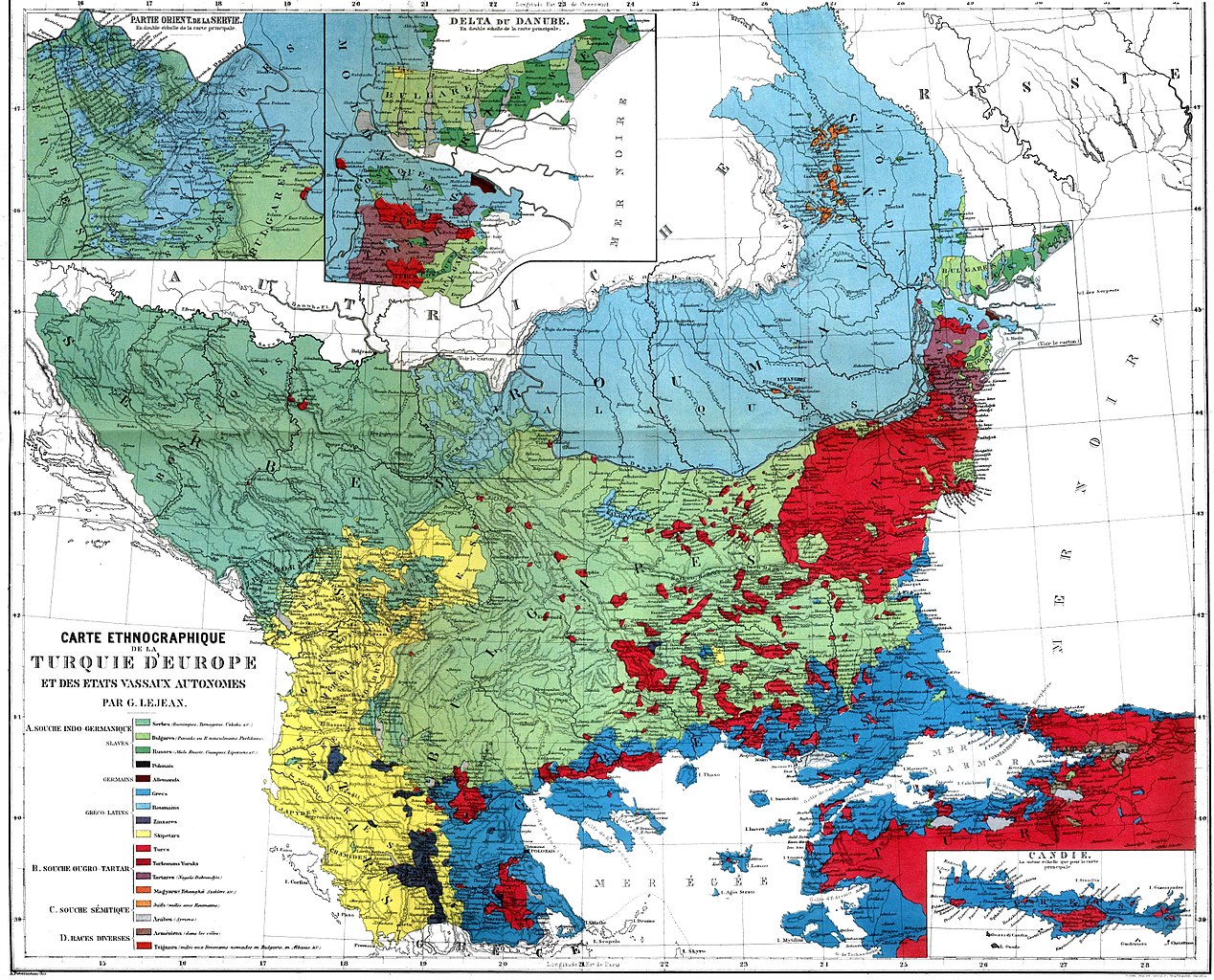
English: Guillaume Lejean's Ethnic map of European Turkey and its vassal states. Български: Етнографска карта на Гийом Лежан от Ethnographie de la Turquie d'Europe, 1861. Français : Carte ethnigraphique de la Turquie d'Europe et des etats vassaux autonomes. Par Guillaume Lejean, 1861. Deutsch: Ethnische Karte der Europäischen Türkei und deren autonomen Vassalenstaaten. Von Guillaume Lejean, 1861. Română: Harta etnică a Turciei europene şi a statelor sale vasale autonome. Autor: Guillaume Lejean, 1861. |
|||||||||||||||||
| 日期 | ||||||||||||||||||
| 來源 | Ethnographie de la Turquie d'Europe | |||||||||||||||||
| 作者 |
|
|||||||||||||||||
| 其他版本 |
Derivative works of this file: |
|||||||||||||||||

.jpg&action=edit§ion=1)
_(2).jpg)
授權條款[編輯]
.jpg&action=edit§ion=2)
本影像屬於公有領域,因為該影像是單純針對一件公有領域原作進行機械掃描,或(從現有證據來看)類似掃描而來的,或該重製照片可以預期不會有版權保護。原作屬於公有領域,是因下述原因:
本標籤主要用於該掃描件有可能使用任何增強功能(如亮度、對比度、色彩調整、銳利化等),而這些增強功能無法達到原創性而無法產生版權的情形下使用。而該標籤也能使用在無法判定本掃描件使用任何增強功能,以及已知使用增強功能但沒有充分證據時。對於採取原始忠實掃描而不使用增強功能的照片,可以適當採用{{PD-old}}標籤取代。對於本標籤的使用方法,參見如何使用PD-Scan標籤。  | ||||
檔案歷史
點選日期/時間以檢視該時間的檔案版本。
| 日期/時間 | 縮圖 | 尺寸 | 用戶 | 備註 | |
|---|---|---|---|---|---|
| 目前 | 2011年1月29日 (六) 19:04 | | 6,280 × 5,072(3.98 MB) | Tfts(對話 | 貢獻) | Reverted to version as of 19:53, 3 December 2009 |
| 2011年1月28日 (五) 23:10 |  | 683 × 547(104 KB) | Ollios(對話 | 貢獻) | Edremit Bay | |
| 2009年12月3日 (四) 19:53 |  | 6,280 × 5,072(3.98 MB) | Alex:D(對話 | 貢獻) | cleaned | |
| 2007年11月15日 (四) 19:53 |  | 6,280 × 5,072(3.86 MB) | Olahus(對話 | 貢獻) | ||
| 2007年11月2日 (五) 11:29 |  | 3,156 × 3,204(2.34 MB) | Olahus(對話 | 貢獻) | {{Information |Description=Ethnic map of the Balkans (1861) |Source= |Date=1861 |Author=G. Lejean |Permission= |other_versions= }} == Licensing == {{PD-old}} |
無法覆蓋此檔案。
檔案用途
下列16個頁面有用到此檔案:
- Atlas of Albania
- Atlas of Bulgaria
- Atlas of European history
- Atlas of Greece
- Atlas of Moldova
- Atlas of North Macedonia
- Atlas of Romania
- Atlas of Serbia
- Северна Македонија
- User:Alex:D/Project2
- User:Olahus
- File:Balkans-ethnic (1861) (2).jpg
- File:Crete - ethnic map, 1861.jpg
- File:Dobrogea-Bugeac harta etnica (1861).JPG
- File:HistoricalRomanijainBosnia.jpg
- File:StariVlah (1861).jpg
.JPG)
.jpg)
全域檔案使用狀況
以下其他 wiki 使用了這個檔案:
- azb.wikipedia.org 的使用狀況
- az.wikipedia.org 的使用狀況
- ba.wikipedia.org 的使用狀況
- bg.wikipedia.org 的使用狀況
- br.wikipedia.org 的使用狀況
- cs.wikipedia.org 的使用狀況
- cv.wikipedia.org 的使用狀況
- de.wikipedia.org 的使用狀況
- en.wikipedia.org 的使用狀況
- Demographic history of Kosovo
- Dobruja
- Demographic history of Macedonia
- Romanians in Serbia
- Talk:Molossians
- Bulgarisation
- User:Olahus
- Talk:Gora dialect
- Albanians in Bulgaria
- Talk:Macedonia (terminology)/Archive 5
- Talk:Epirus/Archive 1
- Talk:Greater Albania/Archive 1
- Wikipedia:Reliable sources/Noticeboard/Archive 83
- Talk:Albanians/Archive 3
- Guillaume Lejean
- Bulgarian Millet
- First Balkan Alliance
- Albania–Bulgaria relations
- Talk:Macedonians (ethnic group)/Archive 17
- Exodus of Muslims from Serbia (1862)
- User:Falcaorib/Balkans ethnic maps
- fr.wikipedia.org 的使用狀況
- he.wikipedia.org 的使用狀況
檢視此檔案的更多全域使用狀況。
.jpg)
詮釋資料
.jpg&oldid=815791542)
分類:
- Slavic dialects of Greece
- French-language maps showing history of Europe
- Historical maps of ethnic groups in Bulgaria
- Historical maps of ethnic groups in Greece
- Historical maps of ethnic groups in North Macedonia
- Historical maps of ethnic groups in Romania
- Historical maps of ethnic groups in Turkey
- Maps showing 19th-century history
- 1860s maps of the Balkans
- Old maps of Romania
- Historical maps of ethnic groups in the Balkans
- Maps by Guillaume Lejean
- 1861 in Romania