File:Banat Josephinische Landaufnahme pg179.jpg
Jump to navigation
Jump to search

Size of this preview: 800 × 541 pixels. Other resolutions: 320 × 216 pixels | 640 × 433 pixels | 1,024 × 692 pixels | 1,280 × 865 pixels | 2,560 × 1,731 pixels | 8,539 × 5,773 pixels.
Original file (8,539 × 5,773 pixels, file size: 32.33 MB, MIME type: image/jpeg)
Captions
Captions
Add a one-line explanation of what this file represents
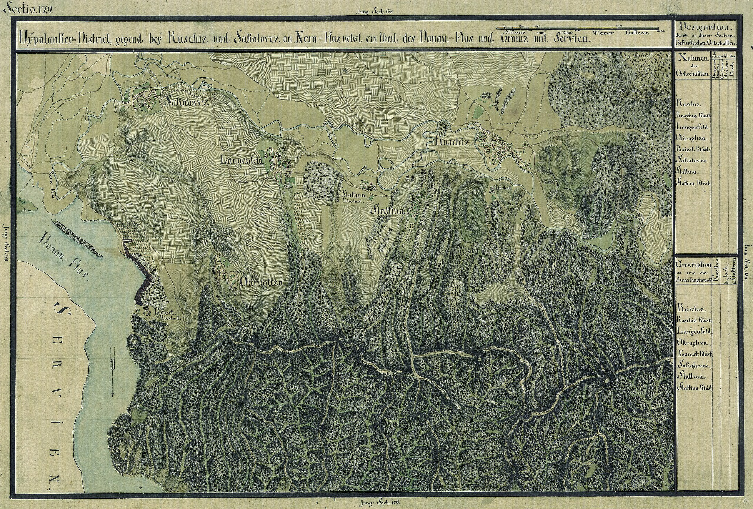
| Name shown on the map Nume din hartă |
Administrative unit Unitate administrativă |
Romanian name Numele românesc |
Hungarian name Numele unguresc |
German name Numele german |
Serbian name Numele sârbesc |
Country today Ţara de astăzi |
|---|---|---|---|---|---|---|
| Kuschiz | Oláh-illír bánsági ezred (Román-illír bánsági kerület) | Kusić | Kusics | Kuschitz | Кусић, Kusiç | Szerbia és Montenegró |
| Kusciz Kloster | Oláh-illír bánsági ezred (Román-illír bánsági kerület) | Kusić | Kusics | Kuschitz | Kusiç | Szerbia és Montenegró |
| Langenfeld | Oláh-illír bánsági ezred (Román-illír bánsági kerület) | Câmpia | Néramezõ | Langenfeld | Луговет | Románia |
| Okrugliza | Oláh-illír bánsági ezred (Román-illír bánsági kerület) | Románia | ||||
| Pasiest Kloster | Oláh-illír bánsági ezred (Román-illír bánsági kerület) | Baziaş | Baziás, Nérasolymos | Baziasch | Базјаш, Bazjaš | Románia |
| Sakalovez | Oláh-illír bánsági ezred (Román-illír bánsági kerület) | Socol | Nérasolymos, Szokolovác | Соколовац (Румунија), Sokolovac | Románia | |
| Slattina | Oláh-illír bánsági ezred (Román-illír bánsági kerület) | Zlatiţa | Néraaranyos | Goldmark | Златица (Румунија), Zlatica | Románia |
| Slattina Kloster | Oláh-illír bánsági ezred (Román-illír bánsági kerület) | Pârneaura | Néraaranyosi zárda | Прњавор (Румунија), Slaticza Pernjavor | Romania |
Summary[edit]
| Description |
Deutsch: Das Banat in: Josephinische Landesaufnahme, 1769-72. Josephinische Landaufnahme pg179 English: The Banat region in the cadastral maps: Josephinische Landesaufnahme, 1769-72. Josephinische Landaufnahme pg179 |
||||
| Date | between 1769 and 1772 | ||||
| Source | Österreichisches Staatsarchiv, Kriegsarchiv | ||||
| Author | Historische Militärkarte der österreichisch-ungarischen Monarchie | ||||
| Permission (Reusing this file) |
|
||||
Clickable map of the Banat region[edit]

File history
Click on a date/time to view the file as it appeared at that time.
| Date/Time | Thumbnail | Dimensions | User | Comment | |
|---|---|---|---|---|---|
| current | 07:24, 5 January 2010 | | 8,539 × 5,773 (32.33 MB) | Asybaris01 (talk | contribs) | {{Information |Description={{ro|1=Banat Josephinische Landaufnahme pg179}} |Source={{own}} |Author=Asybaris01 |Date=1769-72 |Permission= |other_versions= }} Category:Josephinische Landaufnahme |
You cannot overwrite this file.
File usage on Commons
There are no pages that use this file.
File usage on other wikis
The following other wikis use this file:
- Usage on arz.wikipedia.org
- Usage on de.wikipedia.org
- Usage on fr.wikipedia.org
- Usage on hu.wikipedia.org
- Usage on ro.wikipedia.org
- Usage on sr.wikipedia.org