File:Banyan 2017-08-13 0205Z.jpg
Jump to navigation
Jump to search

Size of this preview: 450 × 600 pixels. Other resolutions: 180 × 240 pixels | 360 × 480 pixels | 576 × 768 pixels | 768 × 1,024 pixels | 1,536 × 2,048 pixels | 3,600 × 4,800 pixels.
Original file (3,600 × 4,800 pixels, file size: 3.39 MB, MIME type: image/jpeg)
Captions
Captions
Add a one-line explanation of what this file represents
Summary[edit]
| Description |
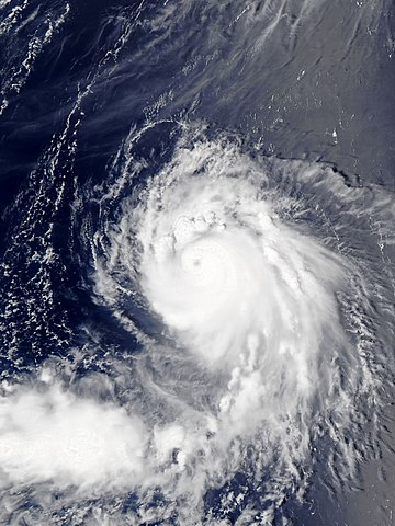
English: Typhoon Banyan northwest of Wake Island on August 13, 2017. |
| Date | |
| Source | EOSDIS Worldview |
| Author | MODIS image captured by NASA’s Aqua satellite |
| Camera location | | View this and other nearby images on: OpenStreetMap |
|---|
Licensing[edit]
| This file is in the public domain in the United States because it was solely created by NASA. NASA copyright policy states that "NASA material is not protected by copyright unless noted". (See Template:PD-USGov, NASA copyright policy page or JPL Image Use Policy.) | ||
 |
Warnings:
|
File history
Click on a date/time to view the file as it appeared at that time.
| Date/Time | Thumbnail | Dimensions | User | Comment | |
|---|---|---|---|---|---|
| current | 08:44, 10 September 2018 | | 3,600 × 4,800 (3.39 MB) | Nino Marakot (talk | contribs) | Reverted to version as of 08:35, 13 August 2017 (UTC) - I think this is better in highlighting the typhoon. |
| 19:46, 26 August 2017 |  | 8,041 × 10,008 (8.21 MB) | Yann (talk | contribs) | Reverted to version as of 04:15, 13 August 2017 (UTC) open as a separate file | |
| 08:35, 13 August 2017 |  | 3,600 × 4,800 (3.39 MB) | Meow (talk | contribs) | Corrected the scale, size, position, and ratio. | |
| 04:15, 13 August 2017 |  | 8,041 × 10,008 (8.21 MB) | ChocolateTrain (talk | contribs) | User created page with UploadWizard |
You cannot overwrite this file.
File usage on Commons
The following 3 pages use this file:
File usage on other wikis
The following other wikis use this file:
- Usage on ja.wikipedia.org
- Usage on vi.wikipedia.org
- Usage on zh.wikipedia.org