File:Basford Vernon railway station.jpg
Jump to navigation
Jump to search
No higher resolution available.
Basford_Vernon_railway_station.jpg (640 × 366 pixels, file size: 117 KB, MIME type: image/jpeg)
Captions
Captions
Add a one-line explanation of what this file represents
Summary
[edit]
| Description |
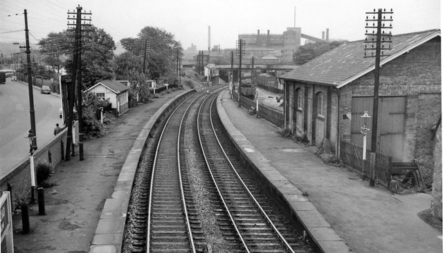
English: Basford Vernon (former Basford LMS) Station View southward, towards Radford Junction and Nottingham (Midland). This station (renamed in 8/52) was closed 4/1/60 (Goods 2/10/67) and remains closed. It was north of Radford Junction, where the Midland main line from Nottingham to Sheffield via Trowell and the Erewash Valley turns off the line to Mansfield and Worksop. The latter line was closed to passengers on 12/10/64. Also most goods traffic ceased on 2/10/67, but the line remained open as far as Newstead to freight and 25 years later it was resuscitated and adapted as the Robin Hood Line, being subsequently reopened out to Worksop. |
| Date | |
| Source | From geograph.org.uk |
| Author | Ben Brooksbank |
| Permission (Reusing this file) |
Creative Commons Attribution Share-alike license 2.0 |
| Camera location | | View this and other nearby images on: OpenStreetMap |
|---|
Licensing
[edit]

|
This image was taken from the Geograph project collection. See this photograph's page on the Geograph website for the photographer's contact details. The copyright on this image is owned by Ben Brooksbank and is licensed for reuse under the Creative Commons Attribution-ShareAlike 2.0 license.
|
This file is licensed under the Creative Commons Attribution-Share Alike 2.0 Generic license.
Attribution: Ben Brooksbank
- You are free:
- to share – to copy, distribute and transmit the work
- to remix – to adapt the work
- Under the following conditions:
- attribution – You must give appropriate credit, provide a link to the license, and indicate if changes were made. You may do so in any reasonable manner, but not in any way that suggests the licensor endorses you or your use.
- share alike – If you remix, transform, or build upon the material, you must distribute your contributions under the same or compatible license as the original.
File history
Click on a date/time to view the file as it appeared at that time.
| Date/Time | Thumbnail | Dimensions | User | Comment | |
|---|---|---|---|---|---|
| current | 16:26, 20 April 2010 | | 640 × 366 (117 KB) | Andrewrabbott (talk | contribs) | == {{int:filedesc}} == {{Information |Description={{en|1=Basford Vernon (former Basford LMS) Station}} |Source=From [http://www.geograph.org.uk/photo/1768922 geograph.org.uk] |Date=1963-08-21 |Author=[http://www.geograph.org.uk/profile/44502 Ben Brooksban |
You cannot overwrite this file.
File usage on Commons
The following 2 pages use this file:
File usage on other wikis
The following other wikis use this file:
- Usage on en.wikipedia.org
- Usage on www.wikidata.org