File:Battle of the Wilderness, May 5 - 6 and 7, 1864, between Lee (60,000) and Grant (120,000) including the approach and the movement toward Spottsylvania (sic) Courthouse LOC 2007627341-39.tif
Jump to navigation
Jump to search

Size of this JPG preview of this TIF file: 800 × 554 pixels. Other resolutions: 320 × 222 pixels | 640 × 443 pixels | 1,024 × 709 pixels | 1,280 × 886 pixels | 2,560 × 1,772 pixels | 5,679 × 3,932 pixels.
Original file (5,679 × 3,932 pixels, file size: 63.89 MB, MIME type: image/tiff)
Captions
Captions
Add a one-line explanation of what this file represents
Summary[edit]
| Description |
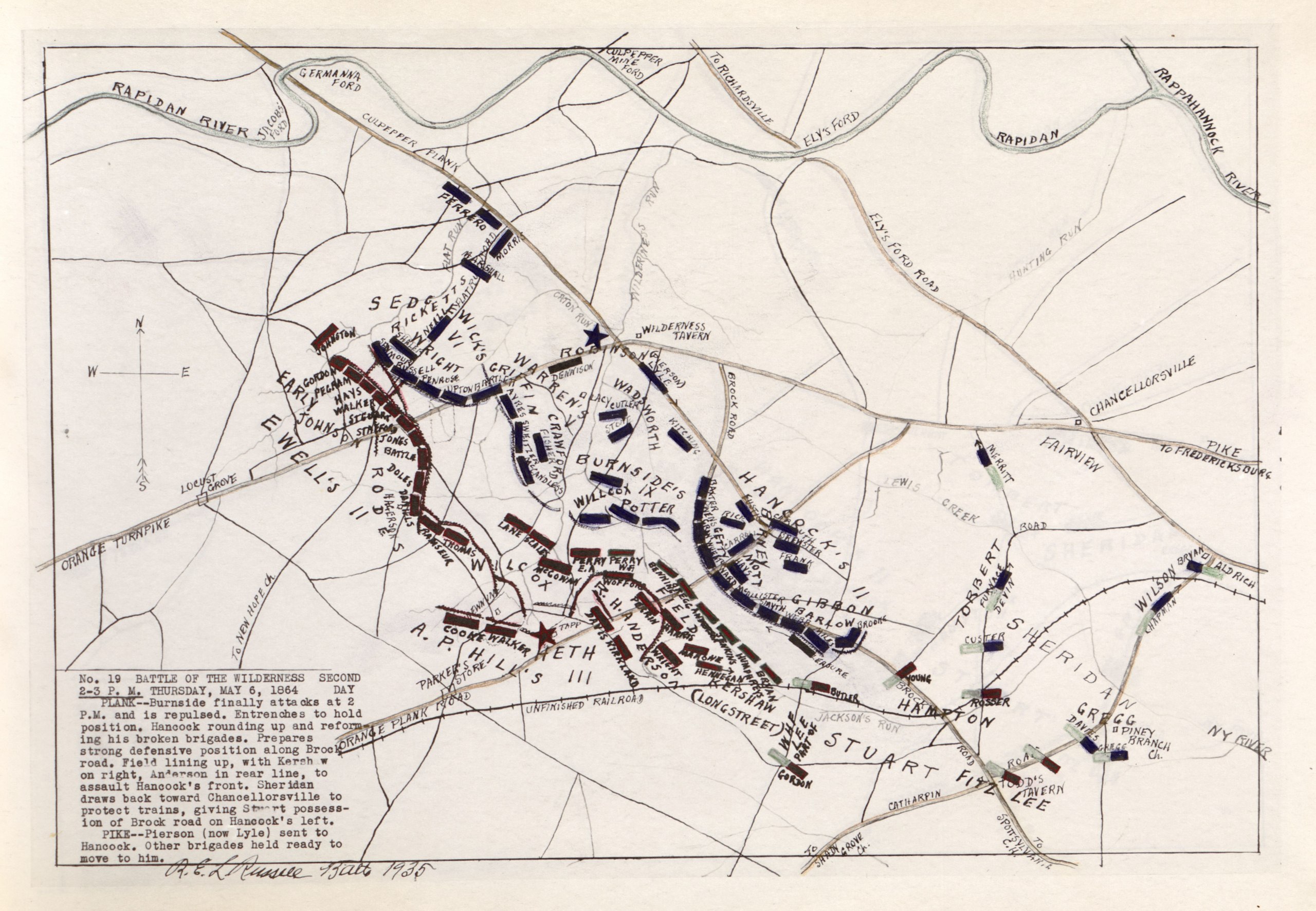
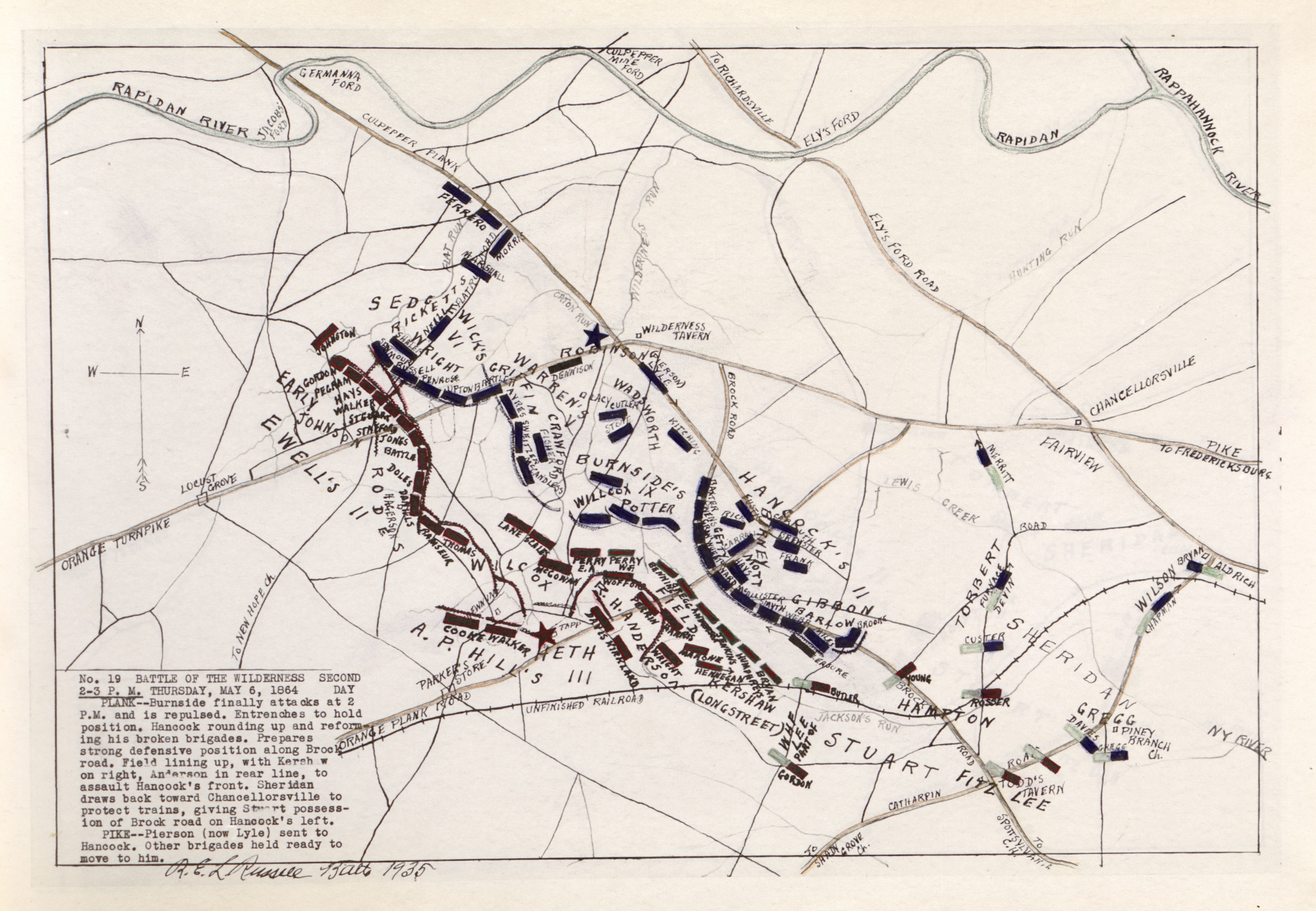
English: "Read numerically." Annotated in pen-and-ink, crayon and pencil. Confederate troop positions are colored red. LC Civil War Maps (2nd ed.), 667 LeGear. Atlases of the United States, 10660 Call no. cited in LC Civil War maps (2nd ed.): G1292.W5S5 .R8 1935 folio. Includes notes. Available also through the Library of Congress Web site as a raster image. |
||
| Title | Battle of the Wilderness, May 5 - 6 and 7, 1864, between Lee (60,000) and Grant (120,000) including the approach and the movement toward Spottsylvania [sic] Courthouse | ||
| Shelf ID | G1294.W49S5 .R8 1935 | ||
| Parent | https://www.loc.gov/resource/g3884wm.gcw0667000/ | ||
| Sheet title | Image 39 of Battle of the Wilderness, May 5 - 6 and 7, 1864, between Lee (60,000) and Grant (120,000) including the approach and the movement toward Spottsylvania [sic] Courthouse | ||
| Date | |||
| Source | https://www.loc.gov/item/2007627341/ | ||
| Author | Russell, Robert E. L. | ||
| Permission (Reusing this file) |
|
||
| Other versions |
|
||
| Location | United States · Spotsylvania County · Virginia | ||
| Part of | Military Battles And Campaigns · American Memory · Civil War Maps · Catalog · Geography And Map Division | ||
| Subject | Spotsylvania County · Virginia · United States · Maps · Wilderness, Battle Of The, Va. · Wilderness, Battle Of The, Va |

_and_Grant_(120,000)_including_the_approach_and_the_movement_toward_Spottsylvania_(sic)_Courthouse_LOC_2007627341-39.jpg)
Licensing[edit]
|
This is a faithful photographic reproduction of a two-dimensional, public domain work of art. The work of art itself is in the public domain for the following reason:
The official position taken by the Wikimedia Foundation is that "faithful reproductions of two-dimensional public domain works of art are public domain".
This photographic reproduction is therefore also considered to be in the public domain in the United States. In other jurisdictions, re-use of this content may be restricted; see Reuse of PD-Art photographs for details. | ||||
File history
Click on a date/time to view the file as it appeared at that time.
| Date/Time | Thumbnail | Dimensions | User | Comment | |
|---|---|---|---|---|---|
| current | 13:21, 10 July 2018 |  | 5,679 × 3,932 (63.89 MB) | Fæ (talk | contribs) | LOC Maps multisheet https://www.loc.gov/item/2007627341/ sheet 39 of 54 #10069 |
You cannot overwrite this file.
File usage on Commons
The following page uses this file:
File usage on other wikis
The following other wikis use this file:
- Usage on hu.wikipedia.org