File:BelgianCongoProvinces-1933-60.svg
跳转到导航
跳转到搜索

此SVG文件的PNG预览的大小:593 × 599像素。 其他分辨率:237 × 240像素 | 475 × 480像素 | 760 × 768像素 | 1,013 × 1,024像素 | 2,026 × 2,048像素 | 640 × 647像素。
原始文件 (SVG文件,尺寸为640 × 647像素,文件大小:180 KB)
说明
说明
添加一行文字以描述该文件所表现的内容
摘要
[编辑]
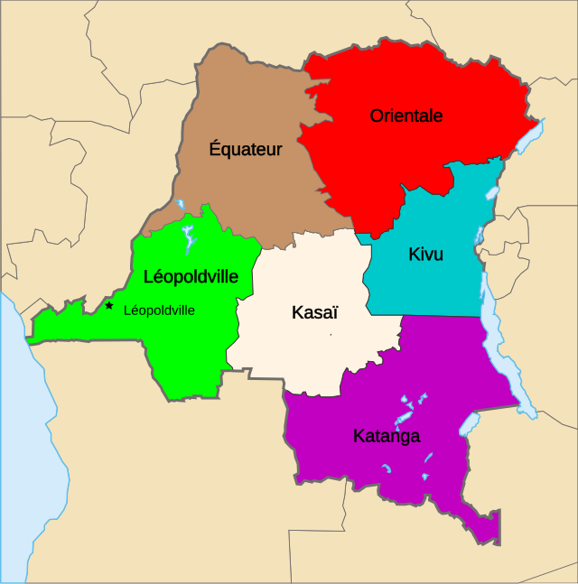
| 描述 | Map of the provinces of the Belgian Congo, from 1933 until Independence (1960). |
| 日期 | |
| 来源 | 基于如下对象的个人作品: Congo Kinshasa Template.svg 由 Moyogo |
| 作者 | Themightyquill |
| SVG开发 |
许可协议
[编辑]
本文件采用知识共享署名-相同方式共享 3.0 未本地化版本许可协议授权。
- 您可以自由地:
- 共享 – 复制、发行并传播本作品
- 修改 – 改编作品
- 惟须遵守下列条件:
- 署名 – 您必须对作品进行署名,提供授权条款的链接,并说明是否对原始内容进行了更改。您可以用任何合理的方式来署名,但不得以任何方式表明许可人认可您或您的使用。
- 相同方式共享 – 如果您再混合、转换或者基于本作品进行创作,您必须以与原先许可协议相同或相兼容的许可协议分发您贡献的作品。
原始上传日志
[编辑]
This image is a derivative work of the following images:
- Congo CrisisMap.png licensed with Cc-by-sa-3.0-migrated-with-disclaimers, GFDL-en
- 2010-08-10T13:57:01Z Beao 440x404 (11149 Bytes) Transparent.
- 2006-10-09T17:13:25Z Kelovy 440x404 (10193 Bytes) == Opis súboru == Map of Territorial Control during the Congo Crisis (1960-61). Color Key *'''Yellow''': National Government based in Léopoldville *'''Red''': Rival National Government based in Stanleyville *'''Green''':
- Congo Kinshasa Template.svg licensed with Cc-by-sa-2.5,2.0,1.0, Cc-by-sa-3.0-migrated, GFDL
- 2006-07-13T08:49:51Z Moyogo 640x647 (270716 Bytes) Lualaba province is Lualaba district + Kolwezi-city district
- 2006-05-28T19:43:22Z Moyogo 640x647 (268950 Bytes) split into layers, added provinces of 1960, 1966 and 1988.
- 2006-05-26T14:57:57Z Moyogo 640x647 (180669 Bytes) improvements to the template: added border of neighbouring countries, provinces' border are uniform, colours drawn from other maps on WP.
- 2005-09-30T10:36:59Z Moyogo 650x650 (117305 Bytes) Template for Province or District maps for the Congo Kinshasa. Each province has an ID in the form Province with the name, e.g. ProvinceKatanga The Provinces are only the outline stroke, no filling Each district has an ID i
Uploaded with derivativeFX
文件历史
点击某个日期/时间查看对应时刻的文件。
| 日期/时间 | 缩略图 | 大小 | 用户 | 备注 | |
|---|---|---|---|---|---|
| 当前 | 2010年12月6日 (一) 01:45 | | 640 × 647(180 KB) | Themightyquill(留言 | 贡献) | {{Information |Description=Map of the provinces of the Belgian Congo, from 1933 until Independence (1960). |Source=*File:Congo_CrisisMap.png *File:Congo_Kinshasa_Template.svg |Date=2010-12-06 01:20 (UTC) |Author=*File:Congo_CrisisMap.png |
您不可以覆盖此文件。
文件用途
以下页面使用本文件:
全域文件用途
以下其他wiki使用此文件:
- de.wikipedia.org上的用途
- en.wikipedia.org上的用途
- fr.wikipedia.org上的用途
- ja.wikipedia.org上的用途
- nl.wikipedia.org上的用途
- sk.wikipedia.org上的用途
- zh.wikipedia.org上的用途