File:Benteng Wolio.jpg
Original file (1,440 × 1,080 pixels, file size: 391 KB, MIME type: image/jpeg)
Captions
Summary
[edit]DescriptionBenteng Wolio.jpg |
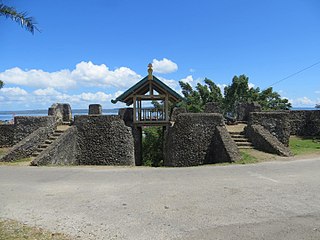
Bahasa Indonesia: Benteng Wolio atau Benteng Keraton Buton merupakan salah satu objek wisata bersejarah di Kota Baubau |
Date | |
Source | kebudayaan.kemdikbud.go.id/wp-content/uploads/sites/5/2017/07/Benteng-Wolio.jpg |
Author | Government of Indonesia |
Camera location | 5° 28′ 23.76″ S, 122° 36′ 06.87″ E | View this and other nearby images on: OpenStreetMap | -5.473267; 122.601908 |
---|
Licensing
[edit]Public domainPublic domainfalsefalse |
This file is in the public domain in Indonesia, because it is published and distributed by the Government of Republic of Indonesia, according to Article 43 of Law 28 of 2014 on copyrights.
There shall be no infringement of Copyright for:
العربية ∙ Basa Bali ∙ English ∙ Bahasa Indonesia ∙ 日本語 ∙ Jawa ∙ Minangkabau ∙ македонски ∙ português ∙ русский ∙ Sunda ∙ 简体中文 ∙ 繁體中文 ∙ +/− |
File history
Click on a date/time to view the file as it appeared at that time.
Date/Time | Thumbnail | Dimensions | User | Comment | |
---|---|---|---|---|---|
current | 21:11, 6 February 2018 | 1,440 × 1,080 (391 KB) | OktaRama2010 (talk | contribs) | User created page with UploadWizard |
You cannot overwrite this file.
File usage on Commons
There are no pages that use this file.
File usage on other wikis
The following other wikis use this file:
- Usage on en.wikipedia.org
- Usage on en.wikivoyage.org
- Usage on eo.wikipedia.org
- Usage on fr.wikipedia.org
- Usage on min.wikipedia.org
Metadata
This file contains additional information such as Exif metadata which may have been added by the digital camera, scanner, or software program used to create or digitize it. If the file has been modified from its original state, some details such as the timestamp may not fully reflect those of the original file. The timestamp is only as accurate as the clock in the camera, and it may be completely wrong.
Camera manufacturer | Canon |
---|---|
Camera model | Canon PowerShot SX260 HS |
Exposure time | 1/1,250 sec (0.0008) |
F-number | f/4 |
ISO speed rating | 160 |
Date and time of data generation | 09:12, 21 September 2016 |
Lens focal length | 4.5 mm |
Latitude | 5° 28′ 23.76″ S |
Longitude | 122° 36′ 6.87″ E |
Altitude | 91.3 meters above sea level |
Orientation | Normal |
Horizontal resolution | 300 dpi |
Vertical resolution | 300 dpi |
Software used | Adobe Photoshop 7.0 |
File change date and time | 09:35, 28 July 2017 |
Y and C positioning | Co-sited |
Exif version | 2.3 |
Date and time of digitizing | 09:12, 21 September 2016 |
Meaning of each component |
|
Image compression mode | 3 |
APEX shutter speed | 10.28125 |
APEX aperture | 4 |
APEX exposure bias | 0 |
Maximum land aperture | 3.625 APEX (f/3.51) |
Metering mode | Pattern |
Flash | Flash did not fire, compulsory flash suppression |
DateTimeOriginal subseconds | 00 |
DateTimeDigitized subseconds | 00 |
Supported Flashpix version | 1 |
Color space | sRGB |
Focal plane X resolution | 16,393.442622951 |
Focal plane Y resolution | 16,393.442622951 |
Focal plane resolution unit | inches |
Sensing method | One-chip color area sensor |
File source | Digital still camera |
Custom image processing | Normal process |
Exposure mode | Auto exposure |
White balance | Auto white balance |
Digital zoom ratio | 1 |
Scene capture type | Standard |
GPS time (atomic clock) | 02:12 |
Receiver status | Measurement in progress |
Geodetic survey data used | WGS-84 |
GPS date | 21 September 2016 |
GPS tag version | 2.3.0.0 |
Rating (out of 5) | 0 |
IIM version | 2 |