File:Bilbrough Grange.jpg
From Wikimedia Commons, the free media repository
Jump to navigation
Jump to search
Size of this preview: 800 × 581 pixels. Other resolutions: 320 × 232 pixels | 640 × 465 pixels | 1,024 × 743 pixels | 1,280 × 929 pixels | 2,560 × 1,859 pixels | 4,821 × 3,500 pixels.
Original file (4,821 × 3,500 pixels, file size: 2.96 MB, MIME type: image/jpeg)
File information
Structured data
Captions
Summary
[edit]DescriptionBilbrough Grange.jpg |
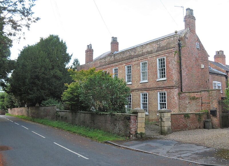
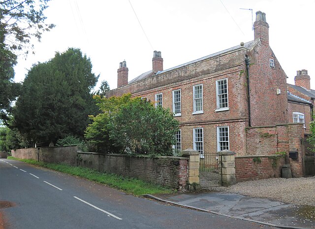
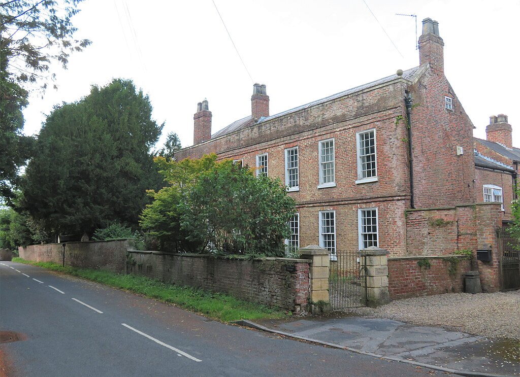
English: Photograph of Bilbrough Grange, Bilbrough, North Yorkshire, England |
Date | |
Source | https://www.geograph.org.uk/photo/7538201 |
Author | Gordon Hatton |
Attribution (required by the license) InfoField | Gordon Hatton / Bilbrough Grange / |
InfoField | Gordon Hatton / Bilbrough Grange |
Camera location | 53° 54′ 44.24″ N, 1° 11′ 42.18″ W | View this and other nearby images on: OpenStreetMap | 53.912290; -1.195050 |
---|
This is a photo of listed building number 1301257. |
Wikidata has entry Bilbrough Grange (Q26588518) with data related to this item. |
Licensing
[edit]This image was taken from the Geograph project collection. See this photograph's page on the Geograph website for the photographer's contact details. The copyright on this image is owned by Gordon Hatton and is licensed for reuse under the Creative Commons Attribution-ShareAlike 2.0 license.
|
This file is licensed under the Creative Commons Attribution-Share Alike 2.0 Generic license.
Attribution: Gordon Hatton
- You are free:
- to share – to copy, distribute and transmit the work
- to remix – to adapt the work
- Under the following conditions:
- attribution – You must give appropriate credit, provide a link to the license, and indicate if changes were made. You may do so in any reasonable manner, but not in any way that suggests the licensor endorses you or your use.
- share alike – If you remix, transform, or build upon the material, you must distribute your contributions under the same or compatible license as the original.
File history
Click on a date/time to view the file as it appeared at that time.
Date/Time | Thumbnail | Dimensions | User | Comment | |
---|---|---|---|---|---|
current | 18:32, 3 March 2024 | 4,821 × 3,500 (2.96 MB) | Bjh21 (talk | contribs) | Replaced with the highest-resolution version that Geograph currently has | |
15:07, 28 February 2024 | 1,024 × 743 (207 KB) | Peter I. Vardy (talk | contribs) | Uploaded a work by Gordon Hatton from https://www.geograph.org.uk/photo/7538201 with UploadWizard |
You cannot overwrite this file.
File usage on Commons
There are no pages that use this file.
File usage on other wikis
The following other wikis use this file:
- Usage on en.wikipedia.org
- Usage on www.wikidata.org
Metadata
This file contains additional information such as Exif metadata which may have been added by the digital camera, scanner, or software program used to create or digitize it. If the file has been modified from its original state, some details such as the timestamp may not fully reflect those of the original file. The timestamp is only as accurate as the clock in the camera, and it may be completely wrong.
Camera manufacturer | Canon |
---|---|
Camera model | Canon PowerShot SX720 HS |
Exposure time | 1/200 sec (0.005) |
F-number | f/4 |
ISO speed rating | 160 |
Date and time of data generation | 16:46, 9 July 2023 |
Lens focal length | 5.346 mm |
Orientation | Normal |
Horizontal resolution | 180 dpi |
Vertical resolution | 180 dpi |
Software used | Windows Photo Editor 10.0.10011.16384 |
File change date and time | 10:48, 10 July 2023 |
Y and C positioning | Co-sited |
Exif version | 2.3 |
Date and time of digitizing | 16:46, 9 July 2023 |
Meaning of each component |
|
Image compression mode | 3 |
APEX shutter speed | 7.65625 |
APEX aperture | 4 |
APEX exposure bias | 0 |
Maximum land aperture | 3.625 APEX (f/3.51) |
Metering mode | Pattern |
Flash | Flash did not fire, compulsory flash suppression |
DateTime subseconds | 08 |
DateTimeOriginal subseconds | 08 |
DateTimeDigitized subseconds | 08 |
Supported Flashpix version | 1 |
Color space | sRGB |
Focal plane X resolution | 21,159.183673469 |
Focal plane Y resolution | 21,130.434782609 |
Focal plane resolution unit | inches |
Sensing method | One-chip color area sensor |
File source | Digital still camera |
Custom image processing | Normal process |
Exposure mode | Auto exposure |
White balance | Auto white balance |
Digital zoom ratio | 1 |
Scene capture type | Standard |
GPS tag version | 2.3.0.0 |
Rating (out of 5) | 0 |
Structured data
Items portrayed in this file
depicts
image/jpeg
6dbb95af4a3d5746beacadd09a9777d9183db5c4
212,404 byte
743 pixel
1,024 pixel
53°54'44.244"N, 1°11'42.180"W
9 July 2023
0.005 second
5.346 millimetre
160
Hidden categories:
- Information field template with formatting
- Files with coordinates missing SDC location of creation (53° N, 2° W)
- Listed buildings in England with known IDs
- Listed buildings in England missing SDC location of creation
- CC-BY-SA-2.0
- Images from Geograph Britain and Ireland
- Images from Geograph Britain and Ireland missing SDC creator
- Images from Geograph Britain and Ireland missing SDC source of file
- Images from Geograph Britain and Ireland missing SDC coordinates of depicted place