File:Blackfriars Station entrance geograph-3262754-by-Ben-Brooksbank.jpg
跳转到导航
跳转到搜索

本预览的尺寸:800 × 495像素。 其他分辨率:320 × 198像素 | 640 × 396像素 | 1,024 × 633像素 | 1,280 × 792像素 | 2,343 × 1,449像素。
原始文件 (2,343 × 1,449像素,文件大小:2.72 MB,MIME类型:image/jpeg)
说明
说明
添加一行文字以描述该文件所表现的内容
摘要
[编辑]
| 描述 |
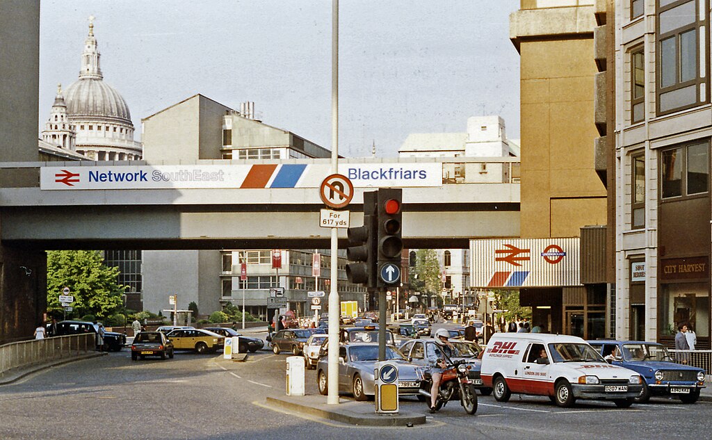
English: Outside Blackfriars Station, up Queen Victoria Street from New Bridge Street, 1989. View eastwards, with entrances on the right to the main (ex-SE&CR and Thameslink) and LT District and Circle Line) stations. The Thameslink service commenced in May 1988 and the bridge is now carrying Thameslink trains to/from Farringdon, King's Cross St Pancras, Luton and Bedford. (City Thameslink station was not yet built - it opened 29/5/90). St Paul's Cathedral is prominent on the left. |
| 日期 | |
| 来源 | From geograph.org.uk |
| 作者 | Ben Brooksbank |
| 授权 (二次使用本文件) |
Creative Commons Attribution Share-alike license 2.0 |
| 署名 (由许可协议要求) | Ben Brooksbank / Outside Blackfriars Station, up Queen Victoria Street from New Bridge Street, 1989 / |
| 相机位置 | | 在以下服务上查看本图像和附近其他图像: OpenStreetMap |
|---|
许可协议
[编辑]

|
本图像来自Geograph工程图集。摄影师的联系信息请见Geograph网站上该照片的页面。本图像的著作权人为Ben Brooksbank,采用知识共享“署名-相同方式共享 2.0”许可协议授权二次使用。
|
本文件采用知识共享署名-相同方式共享 2.0 通用许可协议授权。
署名: Ben Brooksbank
- 您可以自由地:
- 共享 – 复制、发行并传播本作品
- 修改 – 改编作品
- 惟须遵守下列条件:
- 署名 – 您必须对作品进行署名,提供授权条款的链接,并说明是否对原始内容进行了更改。您可以用任何合理的方式来署名,但不得以任何方式表明许可人认可您或您的使用。
- 相同方式共享 – 如果您再混合、转换或者基于本作品进行创作,您必须以与原先许可协议相同或相兼容的许可协议分发您贡献的作品。
文件历史
点击某个日期/时间查看对应时刻的文件。
| 日期/时间 | 缩略图 | 大小 | 用户 | 备注 | |
|---|---|---|---|---|---|
| 当前 | 2012年12月27日 (四) 11:38 | | 2,343 × 1,449(2.72 MB) | Chevin(留言 | 贡献) | == {{int:filedesc}} == {{Information |Description={{en|1='''Outside Blackfriars Station, up Queen Victoria Street from New Bridge Street, 1989.'''<br/> View eastwards, with entrances on the right to the main (ex-SE&CR and Thameslink) and LT District an... |
您不可以覆盖此文件。
文件用途
以下3个页面使用本文件:
全域文件用途
以下其他wiki使用此文件:
- en.wikipedia.org上的用途
- ur.wikipedia.org上的用途
- zh.wikipedia.org上的用途