File:Bordley Stone Circle - geograph.org.uk - 1009488.jpg
Jump to navigation
Jump to search
No higher resolution available.
Bordley_Stone_Circle_-_geograph.org.uk_-_1009488.jpg (640 × 480 pixels, file size: 121 KB, MIME type: image/jpeg)
Captions
Captions
Add a one-line explanation of what this file represents
Summary[edit]
| Description |
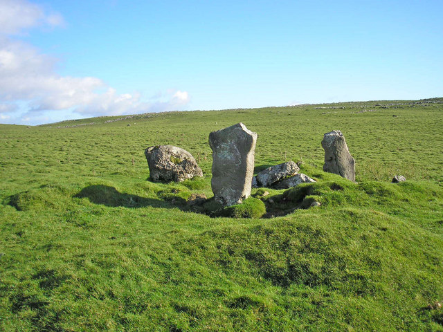
English: Bordley Stone Circle Also known locally as Druid's Altar this is probably a "Four Poster" type of stone circle and dates to the Bronze Age. It consists of a circular bank 15 metres in diameter, 2.7 metres wide and about a metre high. The bank was originally set with upright stones of which only three survive.
The structure has also been interpreted as a small chambered tomb in a round cairn. Shown on the OS map as "Cairn". |
| Date | |
| Source | From geograph.org.uk |
| Author | John Illingworth |
| Attribution (required by the license) | John Illingworth / Bordley Stone Circle / |
| Camera location | | View this and other nearby images on: OpenStreetMap |
|---|
_heading:157.00&language=en)
| Object location | | View this and other nearby images on: OpenStreetMap |
|---|
_heading:157.00&language=en)
Licensing[edit]

|
This image was taken from the Geograph project collection. See this photograph's page on the Geograph website for the photographer's contact details. The copyright on this image is owned by John Illingworth and is licensed for reuse under the Creative Commons Attribution-ShareAlike 2.0 license.
|
This file is licensed under the Creative Commons Attribution-Share Alike 2.0 Generic license.
Attribution: John Illingworth
- You are free:
- to share – to copy, distribute and transmit the work
- to remix – to adapt the work
- Under the following conditions:
- attribution – You must give appropriate credit, provide a link to the license, and indicate if changes were made. You may do so in any reasonable manner, but not in any way that suggests the licensor endorses you or your use.
- share alike – If you remix, transform, or build upon the material, you must distribute your contributions under the same or compatible license as the original.
File history
Click on a date/time to view the file as it appeared at that time.
| Date/Time | Thumbnail | Dimensions | User | Comment | |
|---|---|---|---|---|---|
| current | 06:47, 23 February 2011 | | 640 × 480 (121 KB) | GeographBot (talk | contribs) | == {{int:filedesc}} == {{Information |description={{en|1=Bordley Stone Circle Also known locally as Druid's Altar this is probably a "Four Poster" type of stone circle and dates to the Bronze Age. It consists of a circular bank 15 metres in diameter, 2.7 |
You cannot overwrite this file.
File usage on Commons
There are no pages that use this file.
File usage on other wikis
The following other wikis use this file:
- Usage on cy.wikipedia.org
- Usage on de.wikipedia.org