File:Boston Road, Horncastle - geograph.org.uk - 1409072.jpg
Jump to navigation
Jump to search
No higher resolution available.
Boston_Road,_Horncastle_-_geograph.org.uk_-_1409072.jpg (640 × 480 pixels, file size: 65 KB, MIME type: image/jpeg)
Captions
Captions
Add a one-line explanation of what this file represents
Summary
[edit]
| Description |
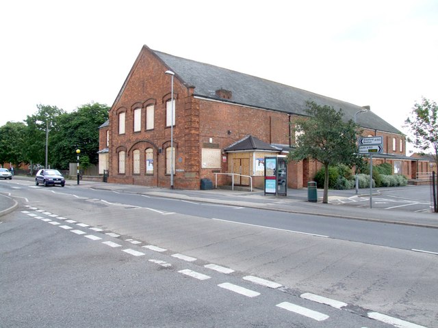
English: Boston Road, Horncastle This former Town Hall is the former New Drill Hall. It was built in 1901, the foundation stone being laid by Right Honorable The Earl of Yarborough, The Right Worshipful Provincial Grand Master of Lincolnshire with full Masonic Ceremonial on Thursday the 13th Day of June. Public donations raised most of the money to build the hall, which cost £2,500. The Horncastle Rifle Volunteers used the premises, which included a rifle range for the practice of firing .22 rifles, and a sergeant/caretakers house.
In WWI the building was used as a Red Cross Hospital and in WWII, for the rest and rehabilitation of servicemen. It wasn't until 1970 that the Drill Hall became a Town Hall and it is now sadly awaiting demolition. I don't think I have a photograph of the hall before it was boarded up and if Richard Croft hadn't given me a nudge, I may well forgotten to take one. The shot was taken from Hangman's Corner. The previous Drill Hall on South Street - https://www.geograph.org.uk/photo/1408871 |
| Date | |
| Source | From geograph.org.uk |
| Author | Dave Hitchborne |
| Attribution (required by the license) | Dave Hitchborne / Boston Road, Horncastle / |
| Camera location | | View this and other nearby images on: OpenStreetMap |
|---|
_heading:225.00&language=en)
| Object location | | View this and other nearby images on: OpenStreetMap |
|---|
_heading:225.00&language=en)
Licensing
[edit]

|
This image was taken from the Geograph project collection. See this photograph's page on the Geograph website for the photographer's contact details. The copyright on this image is owned by Dave Hitchborne and is licensed for reuse under the Creative Commons Attribution-ShareAlike 2.0 license.
|
This file is licensed under the Creative Commons Attribution-Share Alike 2.0 Generic license.
Attribution: Dave Hitchborne
- You are free:
- to share – to copy, distribute and transmit the work
- to remix – to adapt the work
- Under the following conditions:
- attribution – You must give appropriate credit, provide a link to the license, and indicate if changes were made. You may do so in any reasonable manner, but not in any way that suggests the licensor endorses you or your use.
- share alike – If you remix, transform, or build upon the material, you must distribute your contributions under the same or compatible license as the original.
- Remove redundant categories and try to put this image in the most specific category/categories
- Remove this template
- The location categories are based on information from this geonames tool and this OpenStreetMap tool combined with a database. You can also have a look at this tool from mysociety.
- The topic category from Geograph was Town Hall (disused) (find similar images Hall (disused) at Geograph)
File history
Click on a date/time to view the file as it appeared at that time.
| Date/Time | Thumbnail | Dimensions | User | Comment | |
|---|---|---|---|---|---|
| current | 11:49, 1 March 2011 | | 640 × 480 (65 KB) | GeographBot (talk | contribs) | == {{int:filedesc}} == {{Information |description={{en|1=Boston Road, Horncastle This former Town Hall is the former New Drill Hall. It was built in 1901, the foundation stone being laid by Right Honorable The Earl of Yarborough, The Right Worshipful Prov |
You cannot overwrite this file.
File usage on Commons
There are no pages that use this file.