File:Boundary Stone, Woodhead Road, Holmfirth - geograph.org.uk - 1339734.jpg
Jump to navigation
Jump to search
Size of this preview: 450 × 600 pixels. Other resolutions: 180 × 240 pixels | 480 × 640 pixels.
Original file (480 × 640 pixels, file size: 132 KB, MIME type: image/jpeg)
Captions
Captions
Add a one-line explanation of what this file represents
Summary[edit]
| Description |
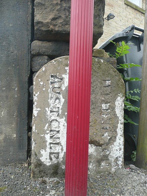
English: Boundary Stone, Woodhead Road, Holmfirth This is puzzling; Holmfirth is actually on the left and Austonley on the right. It was probably erected after Holmfirth Urban District was established in 1894, as before that the stone would have been inscribed 'Upperthong' instead of 'Holmfirth'. One clue is that the 1850 six-inch map shows t he boundary of a detached part of Austonley here, on the left as shown on the stone. I had assumed that the many enclaves in the Holme Valley of one township within the territory of another had been abolished during the local governmaent reorganisation of 1893, but perhaps this one remained. The maroon pole is a bus stop. |
| Date | |
| Source | From geograph.org.uk |
| Author | Humphrey Bolton |
| Attribution (required by the license) | Humphrey Bolton / Boundary Stone, Woodhead Road, Holmfirth / |
| Camera location | | View this and other nearby images on: OpenStreetMap |
|---|
_heading:135.00&language=en)
| Object location | | View this and other nearby images on: OpenStreetMap |
|---|
_heading:135.00&language=en)
Licensing[edit]

|
This image was taken from the Geograph project collection. See this photograph's page on the Geograph website for the photographer's contact details. The copyright on this image is owned by Humphrey Bolton and is licensed for reuse under the Creative Commons Attribution-ShareAlike 2.0 license.
|
This file is licensed under the Creative Commons Attribution-Share Alike 2.0 Generic license.
Attribution: Humphrey Bolton
- You are free:
- to share – to copy, distribute and transmit the work
- to remix – to adapt the work
- Under the following conditions:
- attribution – You must give appropriate credit, provide a link to the license, and indicate if changes were made. You may do so in any reasonable manner, but not in any way that suggests the licensor endorses you or your use.
- share alike – If you remix, transform, or build upon the material, you must distribute your contributions under the same or compatible license as the original.
File history
Click on a date/time to view the file as it appeared at that time.
| Date/Time | Thumbnail | Dimensions | User | Comment | |
|---|---|---|---|---|---|
| current | 00:38, 28 February 2011 | | 480 × 640 (132 KB) | GeographBot (talk | contribs) | == {{int:filedesc}} == {{Information |description={{en|1=Boundary Stone, Woodhead Road, Holmfirth This is puzzling; Holmfirth is actually on the left and Austonley on the right. It was probably erected after Holmfirth Urban District was established in 189 |
You cannot overwrite this file.
File usage on Commons
There are no pages that use this file.