File:C74112s5 Ant.Map Martin Peninsula.jpg
跳转到导航
跳转到搜索

本预览的尺寸:581 × 599像素。 其他分辨率:233 × 240像素 | 465 × 480像素 | 745 × 768像素 | 993 × 1,024像素 | 1,985 × 2,048像素 | 3,621 × 3,735像素。
原始文件 (3,621 × 3,735像素,文件大小:1.52 MB,MIME类型:image/jpeg)
说明
说明
添加一行文字以描述该文件所表现的内容
摘要
[编辑]
| 描述 |
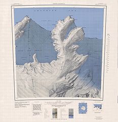
English: 1:250,000-scale topographic reconnaissance map of the Martin Peninsula area from 112°30'-117°W to 73°45'-75°S in Antarctica, including the eastern parts of the Getz Ice Shelf and the western parts of Dotson Ice Shelf. Mapped, edited and published by the U.S. Geological Survey in cooperation with the National Science Foundation. |
|||
| 日期 | ||||
| 来源 | http://usarc.usgs.gov/drg_dload.shtml | |||
| 作者 | United States Geological Survey | |||
| 授权 (二次使用本文件) |
|
文件历史
点击某个日期/时间查看对应时刻的文件。
| 日期/时间 | 缩略图 | 大小 | 用户 | 备注 | |
|---|---|---|---|---|---|
| 当前 | 2005年4月4日 (一) 06:31 | | 3,621 × 3,735(1.52 MB) | Achim Raschka(留言 | 贡献) | Map of Antarctica by the United States Antarctic Ressource Center of the US Geological Society. {{PD-US}} Copyrights and Trademarks USGS-authored or produced data and information are in the public domain. While the content of most USGS web pages is in th |
您不可以覆盖此文件。
文件用途
没有页面使用本文件。
全域文件用途
以下其他wiki使用此文件:
- ceb.wikipedia.org上的用途
- de.wikipedia.org上的用途
- Martin-Halbinsel
- Kap Felt
- Kap Herlacher
- Binder Rocks
- Siglin Rocks
- Schneider Rock
- Klimov Bluff
- Jenkins Heights
- McClinton-Gletscher
- Spaulding-Halbinsel
- Coyer Point
- Jacobsen Head
- Slichter Foreland
- Dorchuck-Gletscher
- Klinger Ridge
- Ellis Ridge
- Keys-Gletscher
- Furman Bluffs
- Philbin Inlet
- Murray Foreland
- Hadley Point
- Maumee-Piedmont-Gletscher
- Rydelek-Eisfälle
- Smythe Shoulder
- Singer-Gletscher
- Tucker Point
- Nowicki Foreland
- en.wikipedia.org上的用途
- fr.wikipedia.org上的用途
- he.wikipedia.org上的用途
- hi.wikipedia.org上的用途
- it.wikipedia.org上的用途
查看此文件的更多全域用途。