File:CEM-44-La-Chine-la-Tartarie-Chinoise-et-le-Thibet-1734-Central-Asia-2574.jpg
跳转到导航
跳转到搜索

本预览的尺寸:800 × 600像素。 其他分辨率:320 × 240像素 | 640 × 480像素 | 1,024 × 768像素 | 1,280 × 960像素 | 2,560 × 1,920像素。
原始文件 (2,560 × 1,920像素,文件大小:2.07 MB,MIME类型:image/jpeg)
说明
说明
添加一行文字以描述该文件所表现的内容
| 描述 |
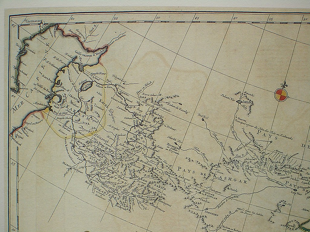
Français : Carte la plus generale et qui comprend la Chine, la Tartarie Chinoise, et le Thibet. Dressee sur les cartes particuliers des RR PP Jesuites, par le Sr. d'Anville..., qui ya joint le pays compris entre Kashgar et la mar Caspienne, tire des geographes et des historiens orientaux
English: A most general map, including China, Chinese Tartary, and Tibet, based on individual maps of the Jesuit fathers. The map gives 1734 as the year, but the modern HKUST publishers say 1737
English: Fragment: Central Asia area
"D’Anville’s maps of China were based on a survey of the Chinese empire that was ordered by the emperor in 1708 and carried out by the Chinese, but under the supervision of Jesuit priests resident in China. The detail about the interior of China was far superior to any previous Western map or atlas. D’Anville’s work remained a standard Western source for the geography of China and adjacent regions until well into the 19th century, when it finally was superseded by more accurate maps." — (World Digital Library) |
| 日期 | 1734, according to the map itself (although the modern publishers say 1737) |
| 来源 |
English: An antique map from the Special Collection "China in Maps" of the Hong Kong University of Science and Technology Library, reproduced by the HKUST Library in the book "China in European Maps", Hong Kong, 2003. ISBN 962-86403-9-9.
Русский: Старинная карта из специальной коллекции Библиотеки Гонконгского научно-технического университета. Опубликована этой библиотекой в книге "China in European Maps" (Китай на европейских картах), Гонконг, 2003. ISBN 962-86403-9-9, тиражом 1000 экз. См. также каталог выставки, Special Collection "China in Maps".
Plate 44 |
| 作者 | |
| 授权 (二次使用本文件) |
Author died more than 70 years ago - public domain |
| 其他版本 |
Entire map |

|
本作品在其来源国以及其他著作权期限是作者逝世后100年或以下的国家和地区属于公有领域。 | |
| 本文件已被确认为免除已知的著作权法限制(包括所有相关权利)。 | |
文件历史
点击某个日期/时间查看对应时刻的文件。
| 日期/时间 | 缩略图 | 大小 | 用户 | 备注 | |
|---|---|---|---|---|---|
| 当前 | 2009年3月22日 (日) 13:32 | | 2,560 × 1,920(2.07 MB) | Vmenkov(留言 | 贡献) | {{Information |Description={{fr|Carte la plus generale et qui comprend la Chine, la Tartarie Chinoise, et le Thibet. Dressee sur les cartes particuliers des RR PP Jesuites, par le Sr. d'Anville..., qui ya joint le pays compris entre Kashgar et la mar Casp |
您不可以覆盖此文件。
文件用途
以下5个页面使用本文件:
- User:Vmenkov/gallery
- File:CEM-44-La-Chine-la-Tartarie-Chinoise-et-le-Thibet-1734-2568.jpg
- File:CEM-44-La-Chine-la-Tartarie-Chinoise-et-le-Thibet-1734-Amur-2572.jpg
- File:CEM-44-La-Chine-la-Tartarie-Chinoise-et-le-Thibet-1734-East-2570.jpg
- File:CEM-44-La-Chine-la-Tartarie-Chinoise-et-le-Thibet-1734-West-2569.jpg
全域文件用途
以下其他wiki使用此文件:
- azb.wikipedia.org上的用途
- bg.wikipedia.org上的用途
- bn.wikipedia.org上的用途
- da.wikipedia.org上的用途
- en.wikipedia.org上的用途
- eo.wikipedia.org上的用途
- es.wikipedia.org上的用途
- fr.wikipedia.org上的用途
- hu.wikipedia.org上的用途
- ko.wikipedia.org上的用途
- no.wikipedia.org上的用途
- pl.wikipedia.org上的用途
- sl.wikipedia.org上的用途
- zh.wikipedia.org上的用途