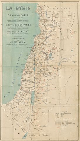
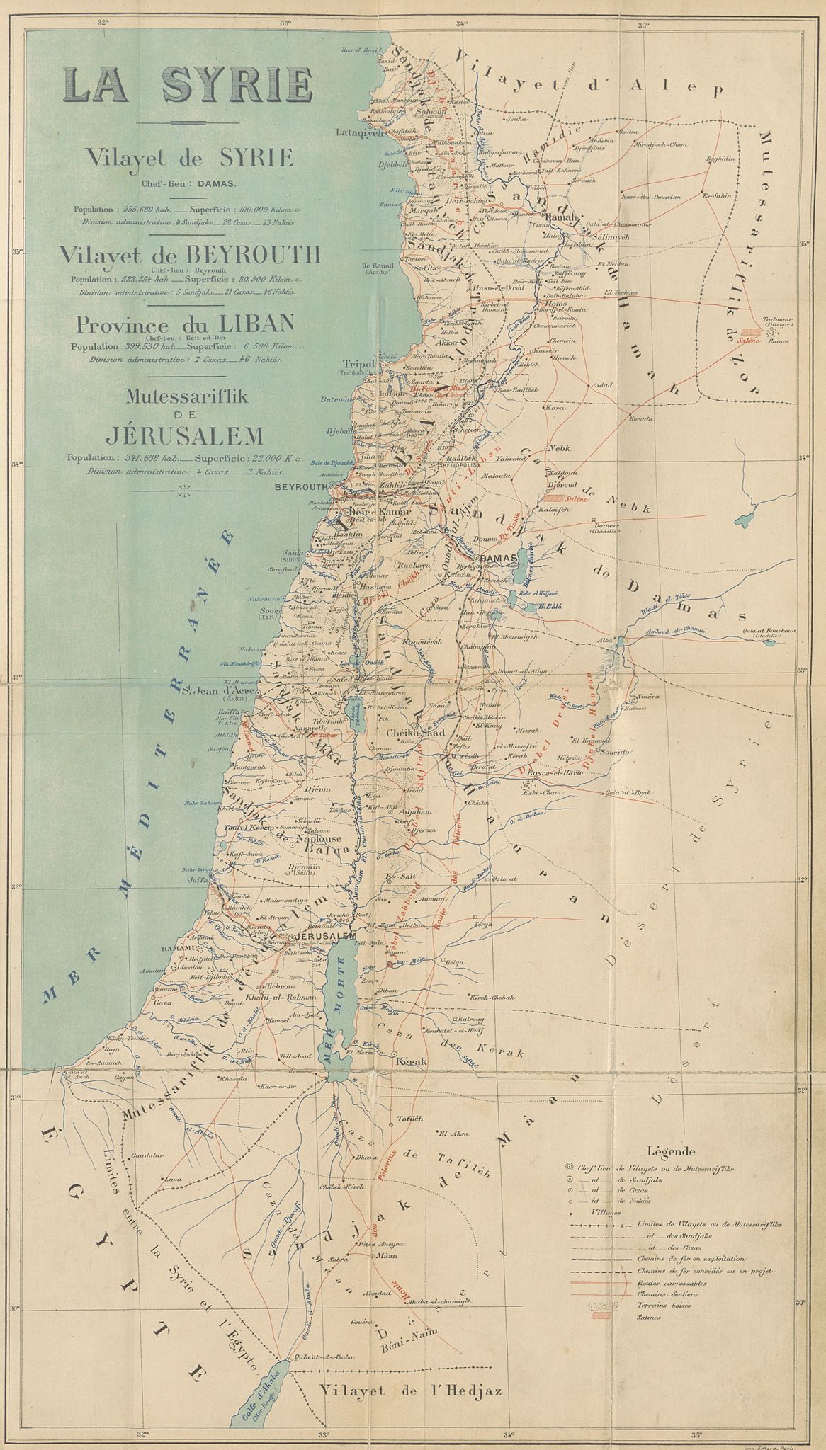
File:CUINET(1896) LA SYRIE.jpg

پروندهٔ اصلی (۳٬۴۵۹ × ۶٬۰۷۵ پیکسل، اندازهٔ پرونده: ۸٫۸۳ مگابایت، نوع MIME پرونده: image/jpeg)
گزینهها
عنوان
خلاصه
[ویرایش]| تاریخ | ۱۸۹۶ | ||||
| آیدی |
British Library HMNTS 010076.i.2. |
||||
| منبع/عکاس |
Image extracted from page 529 of Syrie, Liban et Palestine. Géographie administrative, statistique, descriptive et raisonnée., by CUINET, Vital. Original held and digitised by the British Library. Copied from Flickr. Note: The colours, contrast and appearance of these illustrations are unlikely to be true to life. They are derived from scanned images that have been enhanced for machine interpretation and have been altered from their originals.
|
||||
| اجازهنامه (استفادهٔ مجدد از این پرونده) |
|
||||

_LA_SYRIE.jpg&action=edit§ion=1)
| برچسبها | این نگاره برچسپگذاری شدهاست: برچسپها را در ویکیانبار مشاهده کنید |
_LA_SYRIE.jpg)
تاریخچهٔ پرونده
روی تاریخ/زمانها کلیک کنید تا نسخهٔ مربوط به آن هنگام را ببینید.
| تاریخ/زمان | بندانگشتی | ابعاد | کاربر | توضیح | |
|---|---|---|---|---|---|
| کنونی | ۱ ژانویهٔ ۲۰۱۵، ساعت ۱۴:۴۰ | | ۳٬۴۵۹ در ۶٬۰۷۵ (۸٫۸۳ مگابایت) | Metilsteiner (بحث | مشارکتها) | User created page with UploadWizard |
شما نمیتوانید این پرونده را رونویسی کنید.
کاربرد پرونده
صفحهٔ زیر از این تصویر استفاده میکند:
_LA_SYRIE.jpg)
کاربرد سراسری پرونده
ویکیهای دیگر زیر از این پرونده استفاده میکنند:
- کاربرد در az.wikipedia.org
- کاربرد در ca.wikipedia.org
- کاربرد در de.wikipedia.org
- کاربرد در en.wikipedia.org
- کاربرد در es.wikipedia.org
- کاربرد در fa.wikipedia.org
- کاربرد در fr.wikipedia.org
- کاربرد در id.wikipedia.org
- کاربرد در it.wikipedia.org
- کاربرد در ko.wikipedia.org
- کاربرد در mk.wikipedia.org
- کاربرد در mt.wikipedia.org
- کاربرد در pnb.wikipedia.org
- کاربرد در ro.wikipedia.org
- کاربرد در sr.wikipedia.org
- کاربرد در ur.wikipedia.org
_LA_SYRIE.jpg&oldid=844901167)
- Maps from the Mechanical Curator collection
- Syria Vilayet
- Beirut Vilayet
- Syrie, Liban et Palestine. Géographie administrative, statistique, descriptive et raisonnée (1896) by CUINET
- 1890s maps of the Levant
- French-language maps of Asia
- 1896 maps of the Ottoman Empire
- Mutasarrifate of Jerusalem
- Maps of Ottoman Syria