File:Cambridgeshire UK locator map 2010.svg
پرش به ناوبری
پرش به جستجو

حجم پیشنمایش PNG این SVG file:۴۹۴ × ۶۰۰ پیکسل کیفیتهای دیگر: ۱۹۸ × ۲۴۰ پیکسل | ۳۹۵ × ۴۸۰ پیکسل | ۶۳۳ × ۷۶۸ پیکسل | ۸۴۳ × ۱٬۰۲۴ پیکسل | ۱٬۶۸۷ × ۲٬۰۴۸ پیکسل | ۱٬۱۰۸ × ۱٬۳۴۵ پیکسل.
پروندهٔ اصلی (پروندهٔ اسویجی، با ابعاد ۱٬۱۰۸ × ۱٬۳۴۵ پیکسل، اندازهٔ پرونده: ۳۰۲ کیلوبایت)
گزینهها
عنوان
شرحی یکخطی از محتوای این فایل اضافه کنید
خلاصه[ویرایش]
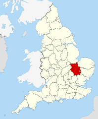
| توضیح | Location of the ceremonial county of Cambridgeshire within England. |
| تاریخ | |
| منبع |
National Geospatial-Intelligence Agency
|
| پدیدآور | Nilfanion |
اجازهنامه[ویرایش]
من، صاحب حقوق قانونی این اثر، به این وسیله این اثر را تحث اجازهنامههای ذیل منتشر میکنم:
این پرونده با اجازهنامهٔ کریتیو کامانز Attribution-Share Alike 3.0 سازگار نشده منتشر شده است.
- شما اجازه دارید:
- برای به اشتراک گذاشتن – برای کپی، توزیع و انتقال اثر
- تلفیق کردن – برای انطباق اثر
- تحت شرایط زیر:
- انتساب – شما باید اعتبار مربوطه را به دست آورید، پیوندی به مجوز ارائه دهید و نشان دهید که آیا تغییرات ایجاد شدهاند یا خیر. شما ممکن است این کار را به هر روش منطقی انجام دهید، اما نه به هر شیوهای که پیشنهاد میکند که مجوزدهنده از شما یا استفادهتان حمایت کند.
- انتشار مشابه – اگر این اثر را تلفیق یا تبدیل میکنید، یا بر پایه آن اثری دیگر خلق میکنید، میبایست مشارکتهای خود را تحت مجوز یکسان یا مشابه با ا اصل آن توزیع کنید.

|
اجازهٔ کپی، پخش و/یا تغییر این سند تحت شرایط مجوز مستندات آزاد گنو، نسخهٔ ۱٫۲ یا هر نسخهٔ بعدتری که توسط بنیاد نرمافزار آزاد منتشر شده؛ بدون بخشهای ناوردا (نامتغیر)، متون روی جلد، و متون پشت جلد، اعطا میشود. یک کپی از مجوز در بخشی تحت عنوان مجوز مستندات آزاد گنو ضمیمه شده است. |
میتوانید مجوز دلخواه خود را برگزینید.

|
This is one of the images forming part of the Valued image set: Locator maps of the Ceremonial counties of England on Wikimedia Commons. The image set has been assessed under the valued image set criteria and is considered the most valued set on Commons within the scope:
Locator maps of the Ceremonial counties of England
You can see its nomination at Commons:Valued image candidates/Locator maps of English ceremonial counties. |
تاریخچهٔ پرونده
روی تاریخ/زمانها کلیک کنید تا نسخهٔ مربوط به آن هنگام را ببینید.
| تاریخ/زمان | بندانگشتی | ابعاد | کاربر | توضیح | |
|---|---|---|---|---|---|
| کنونی | ۲۳ نوامبر ۲۰۱۰، ساعت ۲۲:۳۱ | | ۱٬۱۰۸ در ۱٬۳۴۵ (۳۰۲ کیلوبایت) | Nilfanion (بحث | مشارکتها) | == Summary == {{Information |Description=Location of the ceremonial county of Cambridgeshire within England. |Source=Ordnance Survey [https://www.ordnancesurvey.co.uk/opendatadownload/products.html OpenData]: *Co |
شما نمیتوانید این پرونده را رونویسی کنید.
کاربرد پرونده
صفحههای زیر از این تصویر استفاده میکنند:
- Valued image set: Locator maps of the Ceremonial counties of England
- Commons:Valued image candidates/Locator maps of English ceremonial counties
- Category:Alumni by school in Cambridgeshire
- Category:Births in Cambridgeshire
- Category:Bridges in Cambridgeshire
- Category:Cambridgeshire
- Category:Cambridgeshire in the 16th century
- Category:Cambridgeshire in the 19th century
- Category:Cambridgeshire in the 2000s
- Category:Cambridgeshire in the 2010s
- Category:Cambridgeshire in the 20th century
- Category:Cambridgeshire in the 21st century
- Category:Canals in Cambridgeshire
- Category:Castles in Cambridgeshire
- Category:Cemeteries in Cambridgeshire
- Category:Deaths in Cambridgeshire
- Category:Disused railway stations in Cambridgeshire
- Category:Hospitals in Cambridgeshire
- Category:Local government in Cambridgeshire
- Category:Maps of Cambridgeshire
- Category:Meadows in Cambridgeshire
- Category:Populated places in Cambridgeshire
- Category:Rail transport in Cambridgeshire
- Category:Railway stations in Cambridgeshire
- Category:Rivers of Cambridgeshire
- Category:Roads in Cambridgeshire
- Category:Sports venues in Cambridgeshire
- Category:Towers in Cambridgeshire
- Category:Tunnels in Cambridgeshire
- Category:Views of Cambridgeshire
- Category:Villages in Cambridgeshire
- Category:Visitor attractions in Cambridgeshire
- Category:Windmills in Cambridgeshire
کاربرد سراسری پرونده
ویکیهای دیگر زیر از این پرونده استفاده میکنند:
- کاربرد در af.wikipedia.org
- کاربرد در an.wikipedia.org
- کاربرد در ar.wikipedia.org
- کاربرد در ast.wikipedia.org
- کاربرد در be-tarask.wikipedia.org
- کاربرد در bg.wikipedia.org
- کاربرد در br.wikipedia.org
- کاربرد در ca.wikipedia.org
- کاربرد در ceb.wikipedia.org
- کاربرد در cs.wikipedia.org
- کاربرد در dag.wikipedia.org
- کاربرد در en.wikipedia.org
- Cambridgeshire
- Eye Green
- Paxton Pits Nature Reserve
- Northborough, Cambridgeshire
- Carlton, Cambridgeshire
- Cambridge Business Park
- Brinkley, Cambridgeshire
- Rivey Hill
- Newmarket Ridge
- Free School Lane
- Odsey
- New England, Peterborough
- Westwick, Cambridgeshire
- Upend
- Upton, Peterborough
- Denton and Caldecote
- The Stukeleys
- Template:Cambridgeshire-geo-stub
- Stanground North
- Bainton, Cambridgeshire
- Barham and Woolley
- Old Fletton Urban District
- Queen Adelaide, Cambridgeshire
- Bythorn and Keyston
- Netherton, Peterborough
- Conington, South Cambridgeshire
- Serpentine Green
- Chettisham
- Doddington, Cambridgeshire
- Wothorpe
- Stamford Baron St Martin
- St Martin's Without
- Little Downham
- Coveney, Cambridgeshire
- Glinton, Cambridgeshire
- Melbourn Science Park
نمایش استفادههای سراسری از این پرونده.