File:Castle Bromwich Station (geograph 1648311).jpg
Jump to navigation
Jump to search
No higher resolution available.
Castle_Bromwich_Station_(geograph_1648311).jpg (640 × 481 pixels, file size: 36 KB, MIME type: image/jpeg)
Captions
Captions
Add a one-line explanation of what this file represents
Summary
[edit].jpg&action=edit§ion=1)
| Description |
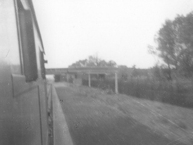
English: Castle Bromwich Station Passenger train runs through disused station at Castle Bromwich, on its way to (first stop) Water Orton. Notice on the platform the remains of the station signpost (two posts) and the railing along the platform. The bridge in the background was once the entrance to the station - A452 Chester Road. See SP1390 : Castle Bromwich Station for later photo from similar location. |
| Date | |
| Source | From geograph.org.uk |
| Author | Michael Westley |
| Permission (Reusing this file) |
Creative Commons Attribution Share-alike license 2.0 |
| Attribution (required by the license) | Michael Westley / Castle Bromwich Station / |
.jpg)
| Camera location | | View this and other nearby images on: OpenStreetMap |
|---|
.jpg¶ms=052.510960_N_-001.798978_E_globe:Earth_type:camera_source:geograph-osgb36(SP13749036)_heading:67.00&language=en)
| Object location | | View this and other nearby images on: OpenStreetMap |
|---|
.jpg¶ms=052.511140_N_-001.798390_E_globe:Earth_class:object_type:object_source:geograph-osgb36(SP13789038)_heading:67.00&language=en)
Licensing
[edit].jpg&action=edit§ion=2)

|
This image was taken from the Geograph project collection. See this photograph's page on the Geograph website for the photographer's contact details. The copyright on this image is owned by Michael Westley and is licensed for reuse under the Creative Commons Attribution-ShareAlike 2.0 license.
|
This file is licensed under the Creative Commons Attribution-Share Alike 2.0 Generic license.
Attribution: Michael Westley
- You are free:
- to share – to copy, distribute and transmit the work
- to remix – to adapt the work
- Under the following conditions:
- attribution – You must give appropriate credit, provide a link to the license, and indicate if changes were made. You may do so in any reasonable manner, but not in any way that suggests the licensor endorses you or your use.
- share alike – If you remix, transform, or build upon the material, you must distribute your contributions under the same or compatible license as the original.
File history
Click on a date/time to view the file as it appeared at that time.
| Date/Time | Thumbnail | Dimensions | User | Comment | |
|---|---|---|---|---|---|
| current | 18:24, 31 October 2020 | | 640 × 481 (36 KB) | Lamberhurst (talk | contribs) | Transferred from geograph.co.uk using [https://tools.wmflabs.org/geograph2commons/ geograph2commons] |
You cannot overwrite this file.
File usage on Commons
The following page uses this file:
.jpg&oldid=850939081)