File:Castles of Munster, Conna, Cork - geograph.org.uk - 1392983.jpg
Jump to navigation
Jump to search
Size of this preview: 400 × 600 pixels. Other resolutions: 160 × 240 pixels | 320 × 480 pixels | 683 × 1,024 pixels.
Original file (683 × 1,024 pixels, file size: 1.18 MB, MIME type: image/jpeg)
Captions
Captions
Add a one-line explanation of what this file represents
Summary[edit]
| Description |
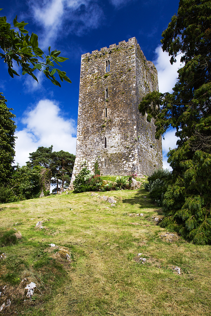
English: Castles of Munster: Conna, Cork Conna Castle has an interesting if tragic history. Towering over the countryside overlooking the River Bride, this fine medieval skyscraper rises 85 feet from a great limestone bluff. Its builder Sir Thomas Ruadh FitzGerald was the eldest son of the 14th Earl of Desmond who died here in 1595. He built the castle in about 1550, and should have succeeded to his father's title and lands, but was disallowed in favour of his younger half-brother Garrett. His claim to the title passed to his eldest son James, known as the "sugan earl" because his claim was sure to fail - which it eventually did. After joining the revolt of 1599, he was betrayed, captured, and died in the Tower of London. That same year Conna was taken by the Earl of Essex, partly dismantled, and later granted to Richard Boyle Earl of Cork, who repaired the tower. In 1645 it was captured by Confederate forces under Lord Castlehaven, and the men of the garrison were put to the sword. The tower's history continued its sad course in 1653 when it was destroyed in a fire in which the three daughters of the steward were burnt to death. |
| Date | |
| Source | From geograph.org.uk |
| Author | Mike Searle |
| Attribution (required by the license) | Mike Searle / Castles of Munster: Conna, Cork (1) / |
| Camera location | | View this and other nearby images on: OpenStreetMap |
|---|
_&language=en)
| Object location | | View this and other nearby images on: OpenStreetMap |
|---|
_&language=en)
Licensing[edit]

|
This image was taken from the Geograph project collection. See this photograph's page on the Geograph website for the photographer's contact details. The copyright on this image is owned by Mike Searle and is licensed for reuse under the Creative Commons Attribution-ShareAlike 2.0 license.
|
This file is licensed under the Creative Commons Attribution-Share Alike 2.0 Generic license.
Attribution: Mike Searle
- You are free:
- to share – to copy, distribute and transmit the work
- to remix – to adapt the work
- Under the following conditions:
- attribution – You must give appropriate credit, provide a link to the license, and indicate if changes were made. You may do so in any reasonable manner, but not in any way that suggests the licensor endorses you or your use.
- share alike – If you remix, transform, or build upon the material, you must distribute your contributions under the same or compatible license as the original.
File history
Click on a date/time to view the file as it appeared at that time.
| Date/Time | Thumbnail | Dimensions | User | Comment | |
|---|---|---|---|---|---|
| current | 20:24, 16 March 2023 | | 683 × 1,024 (1.18 MB) | Geograph Update Bot (talk | contribs) | Higher-resolution version from Geograph |
| 21:31, 28 February 2011 |  | 427 × 640 (425 KB) | GeographBot (talk | contribs) | == {{int:filedesc}} == {{Information |description={{en|1=Castles of Munster: Conna, Cork Conna Castle has an interesting if tragic history. Towering over the countryside overlooking the River Bride, this fine medieval skyscraper rises 85 feet from a great |
You cannot overwrite this file.
File usage on Commons
There are no pages that use this file.
File usage on other wikis
The following other wikis use this file:
- Usage on en.wikipedia.org
- Usage on ga.wikipedia.org
- Usage on ru.wikipedia.org