File:Caucasus-political-fr.svg
Jump to navigation
Jump to search

Size of this PNG preview of this SVG file: 632 × 599 pixels. Other resolutions: 253 × 240 pixels | 506 × 480 pixels | 810 × 768 pixels | 1,080 × 1,024 pixels | 2,159 × 2,048 pixels | 972 × 922 pixels.
Original file (SVG file, nominally 972 × 922 pixels, file size: 370 KB)
Captions
Captions
Add a one-line explanation of what this file represents
| Description |
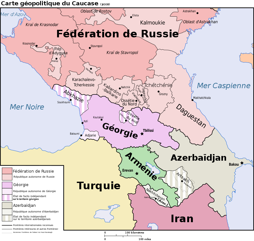
Français : Carte géopolitique du Caucase |
||||||||
| Date | |||||||||
| Source | |||||||||
| Author | User:Jeroencommons, Bourrichon | ||||||||
| Permission (Reusing this file) |
I, the copyright holder of this work, hereby publish it under the following licenses:
This file is licensed under the Creative Commons Attribution-Share Alike 2.5 Generic license.
You may select the license of your choice. |
||||||||
| Other versions |
[]
|


.png)


|
This SVG file contains embedded text that can be translated into your language, using any capable SVG editor, text editor or the SVG Translate tool. For more information see: About translating SVG files. |
This W3C-unspecified vector image was created with Inkscape .
File history
Click on a date/time to view the file as it appeared at that time.
| Date/Time | Thumbnail | Dimensions | User | Comment | |
|---|---|---|---|---|---|
| current | 13:31, 20 January 2020 | | 972 × 922 (370 KB) | Takhirgeran Umar (talk | contribs) | clarification |
| 05:01, 27 April 2018 |  | 972 × 922 (372 KB) | Kentronhayastan (talk | contribs) | Updated "Nagorno-Karabakh" to "Artsakh," the new official name of the self-proclaimed republic. | |
| 16:50, 15 January 2010 |  | 972 × 922 (372 KB) | Bourrichon (talk | contribs) | ?? la correction n'apparaît pas 1 mois après | |
| 18:46, 15 December 2009 |  | 972 × 922 (372 KB) | Bourrichon (talk | contribs) | + corr | |
| 15:25, 6 November 2008 |  | 972 × 922 (372 KB) | Bourrichon (talk | contribs) | {{Information |Description=Carte géopolitique du Caucase |Source=travail personnel ; traduction/translation of Image:Caucasus-political en.svg (auteur=User:Jeroencommons). |Date=2008 |Author= Bourrichon |Permission={{self2|GF |
You cannot overwrite this file.
File usage on Commons
The following 20 pages use this file:
- File:Caucasus-political-fr.svg
- File:Caucasus-political-krc.svg
- File:Caucasus-political-ru.svg
- File:Caucasus-political-tr.svg
- File:Caucasus-political (hy).png
- File:Caucasus-political Fa.svg
- File:Caucasus-political ca.svg
- File:Caucasus-political cs.svg
- File:Caucasus-political de.svg
- File:Caucasus-political en.svg
- File:Caucasus-political es.svg
- File:Caucasus-political ja.svg
- File:Caucasus-political mk.svg
- File:Caucasus-political mzn.svg
- File:Caucasus-political nl.svg
- File:Caucasus-political pl.svg
- File:Caucasus-political pt.svg
- File:Caucasus-political vi.svg
- File:Kaukasian geopoliittinen kartta.svg
- Template:Other versions/Caucasus-political
File usage on other wikis
The following other wikis use this file:
- Usage on br.wikipedia.org
- Usage on fr.wikipedia.org
- Usage on mg.wikipedia.org
- Usage on nl.wikipedia.org
- Usage on pms.wikipedia.org