File:Caucasus 1000 map de.png
Aller à la navigation
Aller à la recherche

Taille de cet aperçu : 771 × 599 pixels. Autres résolutions : 309 × 240 pixels | 618 × 480 pixels | 988 × 768 pixels | 1 280 × 995 pixels | 2 560 × 1 990 pixels | 2 990 × 2 324 pixels.
Fichier d’origine (2 990 × 2 324 pixels, taille du fichier : 3,74 Mio, type MIME : image/png)
Légendes
Légendes
Ajoutez en une ligne la description de ce que représente ce fichier
|
Description[modifier]
| Description |
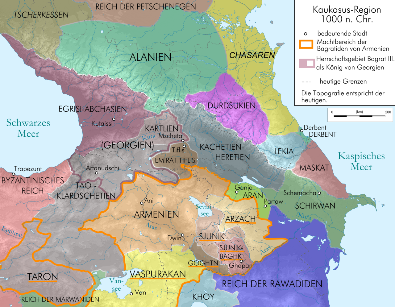
English: Map of Caucasus Region at 1000 AD before death of Dawit III., in German.
Deutsch: Kaukasus-Region 1000 n. Chr. vor dem Tod Dawits III.; Quellen sind Putzger historischer Weltatlas Ausgabe 2005, Heinz Fähnrich: Geschichte Georgiens von den Anfängen bis zur Mongolenherrschaft. Shaker, Aachen 1993, ISBN 3-86111-683-9, File:Georgia map 830-1020.gif , File:Arcax.jpg , File:Vaspurakan kingdom 908-1021 map-fr.svg , http://www.armenica.org/cgi-bin/armenica.cgi?178711717323498=1=3==Armenia==1=3=AAA , File:Alania 10 12.png |
| Date | |
| Source | Own work by uploaderderivate of File:Caucasus topographic map-fr.svg |
| Auteur | Don-kun |
| Autres versions |
   |
Conditions d’utilisation[modifier]
Moi, en tant que détenteur des droits d’auteur sur cette œuvre, je la publie sous les licences suivantes :
Ce fichier est disponible selon les termes de la licence Creative Commons Attribution – Partage dans les Mêmes Conditions 3.0 (non transposée).
- Vous êtes libre :
- de partager – de copier, distribuer et transmettre cette œuvre
- d’adapter – de modifier cette œuvre
- Sous les conditions suivantes :
- paternité – Vous devez donner les informations appropriées concernant l'auteur, fournir un lien vers la licence et indiquer si des modifications ont été faites. Vous pouvez faire cela par tout moyen raisonnable, mais en aucune façon suggérant que l’auteur vous soutient ou approuve l’utilisation que vous en faites.
- partage à l’identique – Si vous modifiez, transformez, ou vous basez sur cette œuvre, vous devez distribuer votre contribution sous la même licence ou une licence compatible avec celle de l’original.

|
Vous avez la permission de copier, distribuer et modifier ce document selon les termes de la GNU Free Documentation License version 1.2 ou toute version ultérieure publiée par la Free Software Foundation, sans sections inaltérables, sans texte de première page de couverture et sans texte de dernière page de couverture. Un exemplaire de la licence est inclus dans la section intitulée GNU Free Documentation License. |
Vous pouvez choisir l’une de ces licences.
Historique du fichier
Cliquer sur une date et heure pour voir le fichier tel qu'il était à ce moment-là.
| Date et heure | Vignette | Dimensions | Utilisateur | Commentaire | |
|---|---|---|---|---|---|
| actuel | 13 janvier 2010 à 23:02 | | 2 990 × 2 324 (3,74 Mio) | Don-kun (d | contributions) | correction, new sources |
| 19 juin 2009 à 15:10 |  | 3 000 × 2 332 (3,69 Mio) | Don-kun (d | contributions) | k | |
| 19 juin 2009 à 15:01 |  | 3 000 × 2 332 (3,69 Mio) | Don-kun (d | contributions) | small cor | |
| 19 juin 2009 à 11:32 |  | 3 000 × 2 332 (3,69 Mio) | Don-kun (d | contributions) | change colors | |
| 18 juin 2009 à 17:20 |  | 3 000 × 2 332 (3,83 Mio) | Don-kun (d | contributions) | change text | |
| 18 juin 2009 à 09:20 |  | 3 000 × 2 332 (3,83 Mio) | Don-kun (d | contributions) | small changes | |
| 11 juin 2009 à 15:53 |  | 3 000 × 2 348 (3,81 Mio) | Don-kun (d | contributions) | some small corrections | |
| 10 juin 2009 à 12:55 |  | 3 000 × 2 348 (3,81 Mio) | Don-kun (d | contributions) | k | |
| 9 juin 2009 à 19:19 |  | 3 000 × 2 348 (3,82 Mio) | Don-kun (d | contributions) | {{Information |Description={{en|1=Map of Caucasus Region at 1000 AD before death of Dawit III., in German.}} {{de|1=Kaukasus-Region 1000 n. Chr. vor dem Tod Dawits III.; Quellen sind Putzger historischer Weltatlas Ausgabe 2005, Heinz Fähnrich: Geschichte |
Vous ne pouvez pas remplacer ce fichier.
Utilisations locales du fichier
Les 9 pages suivantes utilisent ce fichier :
Utilisations du fichier sur d’autres wikis
Les autres wikis suivants utilisent ce fichier :
- Utilisation sur az.wikipedia.org
- Utilisation sur be-tarask.wikipedia.org
- Utilisation sur bs.wikipedia.org
- Utilisation sur ckb.wikipedia.org
- Utilisation sur cs.wikipedia.org
- Utilisation sur de.wikipedia.org
- Kumyken
- Abchasien
- Tao-Klardschetien
- Königreich Georgien
- Wikipedia:Exzellente Bilder/Karten und Satellitenbilder
- Benutzer Diskussion:René Mettke
- Königreich Arzach
- Benutzer:Mikullovci11/Work/Karten
- Wikipedia:Kandidaten für exzellente Bilder/Archiv2009/10
- Datei:Caucasus 1000 map de.png
- Benutzer Diskussion:Don-kun/Archiv4
- Wikipedia:Kandidaten für exzellente Bilder/Archiv2010/1
- Königreich Abchasien
- Benutzer:Don-kun/Kartenserie Kaukasus
- Gurandukt von Abchasien
- Utilisation sur en.wikipedia.org
- Utilisation sur es.wikipedia.org
- Utilisation sur eu.wikipedia.org
- Utilisation sur fr.wikipedia.org
- Utilisation sur hr.wikipedia.org
- Utilisation sur hy.wikipedia.org
- Utilisation sur it.wikipedia.org
- Utilisation sur ja.wikipedia.org
- Utilisation sur ka.wikipedia.org
- Utilisation sur kbd.wikipedia.org
- Utilisation sur ko.wikipedia.org
- Utilisation sur ku.wikipedia.org
- Utilisation sur lt.wikipedia.org
- Utilisation sur lv.wikipedia.org
- Utilisation sur mt.wikipedia.org
- Utilisation sur nl.wikipedia.org
- Utilisation sur pl.wikipedia.org
- Utilisation sur ru.wikipedia.org
Voir davantage sur l’utilisation globale de ce fichier.
Métadonnées
Catégories :
- Maps of the history of Georgia
- Maps of the Bagratuni Kingdom of Armenia
- PNG maps of the history of Azerbaijan
- Maps of the history of the Caucasus
- Maps of the history of Abkhazia
- Maps of the history of South Ossetia
- Maps of the history of the south Caucasus region
- Maps of the history of Naxçıvan
- Maps of Alania
- Maps of the Khazars
- Maps of Circassia
- Maps of the history of Adygea
- Maps of the history of Karachay-Cherkessia
- Maps of the history of Kabardino-Balkaria
- Maps of the history of North Ossetia – Alania
- Maps of the history of Dagestan
- Derivative maps of Putzgers Historischer Schul-Atlas
- Maps of the Caucasus by user Don-kun