File:Cayman Islands Map.svg
跳至導覽
跳至搜尋

此 SVG 檔案的 PNG 預覽的大小:502 × 249 像素。 其他解析度:320 × 159 像素 | 640 × 317 像素 | 1,024 × 508 像素 | 1,280 × 635 像素 | 2,560 × 1,270 像素。
原始檔案 (SVG 檔案,表面大小:502 × 249 像素,檔案大小:18 KB)
說明
說明
添加單行說明來描述出檔案所代表的內容
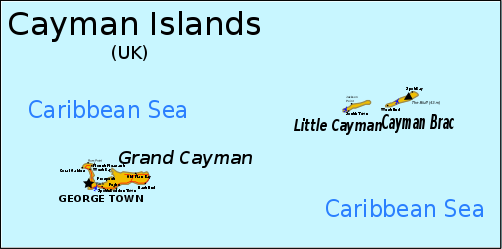
Map of the Cayman Islands
摘要
[編輯]
| 描述 |
English: Map of the Cayman Islands. Information from CIA MAP, Yahoo Map, [1] Can be translated through version 1 here, although text must be converted to path due to rendering problems. |
| 日期 | original unknown |
| 來源 | outline from PlaniGlobe |
| 作者 | Planiglobe (outline), RaviC |
| 其他版本 |
Derivative works of this file: |
| SVG開發 |
![[1]](http://www.wordtravels.com/images/map/Cayman_Islands_map.jpg)
授權條款
[編輯]
此檔案採用創用CC 姓名標示 2.5 通用版授權條款。
- 您可以自由:
- 分享 – 複製、發佈和傳播本作品
- 重新修改 – 創作演繹作品
- 惟需遵照下列條件:
- 姓名標示 – 您必須指名出正確的製作者,和提供授權條款的連結,以及表示是否有對內容上做出變更。您可以用任何合理的方式來行動,但不得以任何方式表明授權條款是對您許可或是由您所使用。
檔案歷史
點選日期/時間以檢視該時間的檔案版本。
| 日期/時間 | 縮圖 | 尺寸 | 使用者 | 備註 | |
|---|---|---|---|---|---|
| 目前 | 2024年6月16日 (日) 09:56 | | 502 × 249(18 KB) | ToprakM(留言 | 貢獻) | File uploaded using svgtranslate tool (https://svgtranslate.toolforge.org/). Added translation for tr. |
| 2018年11月16日 (五) 22:41 |  | 502 × 249(15 KB) | JoKalliauer(留言 | 貢獻) | phab:T35245 real text again | |
| 2009年4月7日 (二) 16:20 |  | 502 × 249(257 KB) | RaviC(留言 | 貢獻) | added more information from http://www.wordtravels.com/images/map/Cayman_Islands_map.jpg | |
| 2009年4月6日 (一) 20:51 |  | 502 × 249(235 KB) | Pbrks(留言 | 貢獻) | rendering problems | |
| 2009年4月6日 (一) 19:18 |  | 502 × 249(23 KB) | RaviC(留言 | 貢獻) | {{Information |Description={{en|1=Map of the Cayman Islands.}} Information from [http://upload.wikimedia.org/wikipedia/commons/2/20/Cayman_Islands-CIA_WFB_Map.png CIA MAP], [http://www.mbs.maine.edu/~strong_robert/Cayman%20Islands%20trip/Cayman%20Islands% |
無法覆蓋此檔案。
檔案用途
下列11個頁面有用到此檔案:
- Atlas of the Cayman Islands
- Cayman Islands
- Maps of Cayman Islands
- User:JoKalliauer
- User:JoKalliauer/Pictures
- User:Magog the Ogre/Multilingual legend/2024 June 16-20
- Commons:Help desk/Archive/2013/04
- File:Cayman Islands Map.png
- File:Cayman Islands Map mk.svg
- File:Cayman Islands Map zh.svg
- File:Cayman Islands Map zh 2.svg
全域檔案使用狀況
以下其他 wiki 使用了這個檔案:
- als.wikipedia.org 的使用狀況
- ba.wikipedia.org 的使用狀況
- bn.wikipedia.org 的使用狀況
- br.wikipedia.org 的使用狀況
- en.wikipedia.org 的使用狀況
- Cayman Islands
- Geography of the Cayman Islands
- List of airports in the Cayman Islands
- Portal:Caribbean/Selected geography article
- Portal:Caribbean/Selected geography article/12
- Cyclura nubila caymanensis
- Outline of the Cayman Islands
- Index of Cayman Islands–related articles
- Wikipedia:Graphics Lab/Image workshop/Archive/Apr 2009
- Talk:British Isles/Archive 30
- es.wikipedia.org 的使用狀況
- fa.wikipedia.org 的使用狀況
- fi.wikipedia.org 的使用狀況
- fr.wikipedia.org 的使用狀況
- he.wikipedia.org 的使用狀況
- id.wikipedia.org 的使用狀況
- it.wikipedia.org 的使用狀況
- ja.wikipedia.org 的使用狀況
- kn.wikipedia.org 的使用狀況
- lb.wikipedia.org 的使用狀況
- lt.wikipedia.org 的使用狀況
- ml.wikipedia.org 的使用狀況
- mrj.wikipedia.org 的使用狀況
- nl.wikipedia.org 的使用狀況
- no.wikipedia.org 的使用狀況
- pcd.wikipedia.org 的使用狀況
- pl.wikipedia.org 的使用狀況
- pt.wikipedia.org 的使用狀況
- ru.wikipedia.org 的使用狀況
- sh.wikipedia.org 的使用狀況
- sv.wikipedia.org 的使用狀況
- tr.wikipedia.org 的使用狀況
- tr.wiktionary.org 的使用狀況
- tt.wikipedia.org 的使用狀況
- uk.wikipedia.org 的使用狀況
檢視此檔案的更多全域使用狀況。