File:Chain Home radar station, Rye - geograph.org.uk - 307108.jpg
Jump to navigation
Jump to search
No higher resolution available.
Chain_Home_radar_station,_Rye_-_geograph.org.uk_-_307108.jpg (640 × 426 pixels, file size: 150 KB, MIME type: image/jpeg)
Captions
Captions
Add a one-line explanation of what this file represents
Summary
[edit]
| Description |
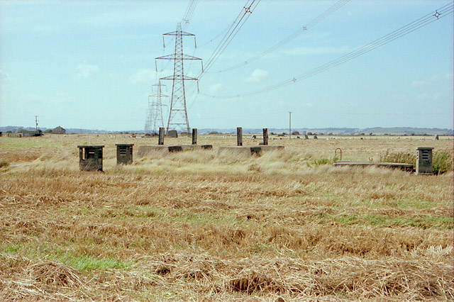
English: Chain Home radar station, Rye Derelict in 1983. This is a "buried reserve": an underground bunker that would be used either to transmit or receive should the main, above ground, equipment be damaged by enemy action. In the foreground are air vents and, at right, a sliding concrete hatch. Beyond is a concrete base for a tower that would only be erected when the buried reserve was brought into use. For more information on Chain Home radar see http://www.ventnorradar.co.uk/CH.htm
Also shown, the modern 400 KV supergrid carrying power from Dungeness to Ninfield. It was expected to carry 2350 MW during the 2006 winter peak. The house in distance left is probably Knatchbull Cottages on the A259. |
| Date | |
| Source | From geograph.org.uk |
| Author | Peter Facey |
| Attribution (required by the license) | Peter Facey / Chain Home radar station, Rye / |
| Camera location | | View this and other nearby images on: OpenStreetMap |
|---|
_heading:315.00&language=en)
| Object location | | View this and other nearby images on: OpenStreetMap |
|---|
_heading:315.00&language=en)
Licensing
[edit]

|
This image was taken from the Geograph project collection. See this photograph's page on the Geograph website for the photographer's contact details. The copyright on this image is owned by Peter Facey and is licensed for reuse under the Creative Commons Attribution-ShareAlike 2.0 license.
|
This file is licensed under the Creative Commons Attribution-Share Alike 2.0 Generic license.
Attribution: Peter Facey
- You are free:
- to share – to copy, distribute and transmit the work
- to remix – to adapt the work
- Under the following conditions:
- attribution – You must give appropriate credit, provide a link to the license, and indicate if changes were made. You may do so in any reasonable manner, but not in any way that suggests the licensor endorses you or your use.
- share alike – If you remix, transform, or build upon the material, you must distribute your contributions under the same or compatible license as the original.
File history
Click on a date/time to view the file as it appeared at that time.
| Date/Time | Thumbnail | Dimensions | User | Comment | |
|---|---|---|---|---|---|
| current | 21:33, 22 December 2010 | | 640 × 426 (150 KB) | GeographBot (talk | contribs) | == {{int:filedesc}} == {{Information |description={{en|1=Chain Home radar station, Rye Derelict in 1983. This is a "buried reserve": an underground bunker that would be used either to transmit or receive should the main, above ground, equipment be damaged |
You cannot overwrite this file.
File usage on Commons
There are no pages that use this file.