File:Chanute AFB-12apr1998.jpg
Jump to navigation
Jump to search

Size of this preview: 635 × 599 pixels. Other resolutions: 254 × 240 pixels | 509 × 480 pixels | 780 × 736 pixels.
Original file (780 × 736 pixels, file size: 169 KB, MIME type: image/jpeg)
Captions
Captions
Add a one-line explanation of what this file represents
|
This is an image of a place or building that is listed on the National Register of Historic Places in the United States of America. Its reference number is 6000594. |
Summary
[edit]
| Description | |
| Date | |
| Source |
USGS The National Map, via MSR Maps (formerly TerraServer-USA) |
| Author | United States Geological Survey (USGS) |
| Permission (Reusing this file) |
Public domain |
| Object location | | View this and other nearby images on: OpenStreetMap |
|---|
Licensing
[edit]
This image is in the public domain in the United States because it only contains materials that originally came from the United States Geological Survey, an agency of the United States Department of the Interior. For more information, see the official USGS copyright policy.
|
File history
Click on a date/time to view the file as it appeared at that time.
| Date/Time | Thumbnail | Dimensions | User | Comment | |
|---|---|---|---|---|---|
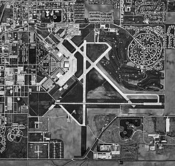
| current | 14:56, 11 April 2008 | | 780 × 736 (169 KB) | Bwmoll3 (talk | contribs) | {{Information |Description=Chanute AFB Illinois |Source=USGS Digital Orthophoto via Terraserver http://terraserver-usa.com/map.aspx?t=1&s=12&lon=-88.143056&lat=40.294444&w=800&h=800&opt=0&f=&fs=8&fc=ffffff99&lp=---+None+--- |Date=12 Apr 1998 |Author=USGS |
You cannot overwrite this file.
File usage on Commons
There are no pages that use this file.
File usage on other wikis
The following other wikis use this file:
- Usage on de.wikipedia.org
- Usage on en.wikipedia.org
- Usage on hu.wikipedia.org